


 |
GES512S - GEOGRAPHIC INFORMATION SYSTEMS - 1ST OPP - JUNE 2024 |
|
|
1 Page 1 |
▲back to top |
nAm I BIA unlVERSITY
OF SCIEnCE Ano TECHnOLOGY
FACULTYOF ENGINEERINGAND THE BUILTENVIRONMENT
DEPARTMENTOF LANDAND SPATIALSCIENCES
QUALIFICATIONS:
BACHELOROF NATURALRESOURCEMANAGEMENT,BACHELOROF NATURALRESOURCE
MANAGEMENTIN NATURECONSERVATION
QUALIFICATIONCODES:
07BNRS,07BNTC
LEVEL:5
COURSECODE:GES512S
COURSENAME: GEOGRAPHICINFORMATION
SESSION:JUNE2024
SYSTEMS1
PAPER:THEORY
DURATION:3 HOURS
..
MARKS:100
FIRST OPPORTUNITY EXAMINATION QUESTION PAPER
EXAMINER:
Ms Roxanne Murangi
MODERATOR: Mr. Erich Naoseb
INSTRUCTIONS
1. Write your student number on each answer sheet used.
2. Answer ALLthe questions.
3. Read each question carefully before attempting to answer.
4. Write clearly and neatly.
1. Pen.
2. Pencil.
3. Eraser.
4. Ruler.
PERMISSIBLEMATERIALS
This paper consistsof six (6) pages (includingthis cover page).
|
|
2 Page 2 |
▲back to top |
Geographic Information Systems 1
Question 1
GES512s
Answer the multiple choice questions listed below. Please select the one (1) most relevant
response to the following questions. Indicate the correct answer on the answer sheet.
1.1. GIS represents a location in ___ dimensional coordinates.
(1)
A. 2
B. 3
C. 4
D. 5
1.2. What are the two factors used to categorize all maps?
(1)
A. Political Boundaries and Color
B. Climate and Temperature
C. Sizeand Theme
D. Scaleand Contents
1.3. What is the function of geoprocessing?
(1)
A. Manipulates global data
B. Manipulates spatial data
C. Manipulates local data
D. Manipulates special data
1.4. The scientist Roger Tomlinson created ___ for analysing and storing a large amount
of data.
(1)
A. Database
B. SD card
C. Pen drive
D. Computer
First Opportunity Question Paper
Page 2 of6
June 2024
|
|
3 Page 3 |
▲back to top |
Geographic Information Systems 1
1.5. What function is performed by the data input/capture subsystem of GIS?
A. Transformation of Data
B. Storage of Data Elements
C. Retrieval of Data Elements
D. Acquiring Data
GES512s
(1)
[5]
Question 2
Which of the following GIS-related statements are true or false? On the answer sheet,
indicate True or False. Provide the correct answer if false.
2.1. Satellite imagery cannot be integrated into GIS systems for analysis and mapping
purposes.
(2)
2.2. Google Maps is an example of a GISsoftware.
(2)
2.3. GIScan only work with data in the form of maps and cannot handle tabular data.
(2)
2.4. All layers to be used together in a GISoperation must align spatially.
(2)
2.5. GIS is primarily used for mapping physical features of the Earth's surface and cannot
represent abstract data.
(2)
[10)
First Opportunity Question Paper
Page3 of 6
June 2024
|
|
4 Page 4 |
▲back to top |

Geographic Information Systems 1
Question 3
GES512s
3.1. How does data become information?
(3)
3.2. Provide one definition of what a GISis.
(4)
3.3. Differentiate between GISand IS, providing examples of each.
(4)
3.4. What are the three (3) Geographical Information Technologies?
(3)
3.5. What are the functions of a GIS? List them and provide one (1) example for each
function.
(8)
3.6. Explain the term Geographic Phenomena. Provide three (3) examples of Geographic
Phenomena.
(4)
3.7. Imagine a tree. How would you keep track of and communicate information about this
tree to other people who need to know all about it? In your explanation provide at least
six (6) non-spatial attributes that are considered important to describe this tree.
(4)
(30]
Question 4
4.1. Provide a brief explanation of the term location.
(2)
4.2. What is the purpose of a coordinate system in GIS?
(2)
4.3. List three (3) characteristics that make a coordinate system. Provide one (1) example
for each.
(3)
First Opportunity Question Paper
Page4 of 6
June 2024
|
|
5 Page 5 |
▲back to top |
Geographic Information Systems 1
GES512s
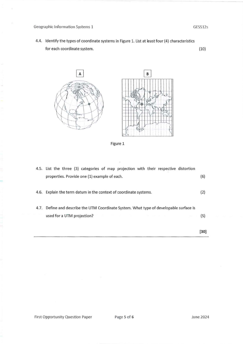
4.4. Identify the types of coordinate systems in Figure 1. List at least four (4) characteristics
for each coordinate system.
(10)
Figure 1
.- ,..-I.~....
>-
' _,, -
\\
4.5. List the three (3) categories of map projection with their respective distortion
properties. Provide one (1) example of each.
(6)
4.6. Explain the term datum in the context of coordinate systems.
(2)
4.7. Define and describe the UTMCoordinate System. What type of developable surface is
used for a UTMprojection?
(5)
(30)
First Opportunity Question Paper
Page5 of 6
June 2024
|
|
6 Page 6 |
▲back to top |

Geographic Information Systems 1
Question 5
GE5512s
5.1. Which of the data models relate to picture elements? Outline some of its
characteristics.
(4)
5.2. Identify the type of vector-based overlays in Figure 2. Briefly explain each overlay.
(6)
IA I
( +
=
I
I
l!J
NOT
':
)-
/
(
--
)
Figure 2
5.3. GISqueries can be performed in several ways, including by location. Outline any three
(3) applications to this method of selection.
(6)
5.4. Data accuracy is a state~ent of how close·lya bit of data represents the real world. It
involves five (5) statements. list them.
(5)
5.5. Outline the difference between thematic and topographic maps.
(4)
[25]
First Opportunity Question Paper
Page 6 of 6
June 2024