


 |
GES512S - GEOGRAPHIC INFORMATION SYSTEMS - 2ND OPP - JULY 2024 |
|
|
1 Page 1 |
▲back to top |
nAmlBIA unlVERSITY
OF SCIEnCE Ano TECHnOLOGY
FACULTYOF ENGINEERINGAND THE BUILTENVIRONMENT
DEPARTMENTOF LANDAND SPATIALSCIENCES
QUALIFICATIONS:
BACHELOROF NATURALRESOURCEMANAGEMENT,BACHELOROF NATURALRESOURCE
MANAGEMENTIN NATURECONSERVATION
QUALIFICATIONCODES:
LEVEL: 5
07BNRS,07BNTC
COURSECODE:GES512S
COURSENAME: GEOGRAPHICINFORMATIONSYSTEMS
1
SESSION:JULY2024
PAPER:THEORY
DURATION:3 HOURS
MARKS: 100
SECOND OPPORTUNITY/SUPPLEMENTARY EXAMINATION QUESTION PAPER
EXAMINER:
MODERATOR:
Ms Roxanne Murangi
Mr Erich Naoseb
INSTRUCTIONS
1. Write your student number on each answer sheet used.
2. Answer ALLthe questions.
3. Read each question carefully before attempting to answer.
4. Write clearly and neatly.
1. Pen.
2. Pencil.
3. Eraser
4. Ruler.
PERMISSIBLEMATERIALS
This paper consistsof six (6) pages(includingthis cover page).
|
|
2 Page 2 |
▲back to top |
Geographic Information Systems 1
GESS12s
Question 1
Answer the multiple choice questions listed below. Please select the one (1) most relevant
response to the following questions. Indicate the correct answer on the answer sheet.
1.1. GIS represents Y-coordinates in a ___ direction.
(1)
A. Tangentially
B. Vertical
C. Horizontal
D. Positional
1.2. Examplesof discrete fields are.
(1)
A. Air temperature
B. Barometric pressure
C. Soil salinity
D. Land classification
1.3. Which type of map projection is best suited for use as regional or hemispheric maps,
but rarely for a complete world map?
(1)
A. Equivalent Map Projection
B. Cylindrical Map Projection
C. Conical Map Projection
D. Azimuthal Map Projection
1.4. What is the most essential component of a GIS?
(1)
A. Graphical Representation
B. Information Database
C. Software
D. Satellite
2nd Opportunity/Supplementary Exam Question Paper Page2 of 6
July 2024
|
|
3 Page 3 |
▲back to top |
Geographic Information Systems 1
1.5. What is the other name for a geographic coordinate system?
A. Rectangular Coordinate System
B. Spherical Grid System
C. Latitude and Longitude System
D. Parallel Coordinate System
GESS12s
(1)
[5]
Question 2
Which of the following GIS-related statements are true or false? On the answer sheet,
indicate True or False. Provide the correct answer if false.
2.1. The location of any point on the earth's surface about a rectangular coordinate system is
generally termed a relative position.
(2)
2.2. Data can be shared in the process of GIS.
(2)
2.3. GIShas no significant role in disaster management and emergency response activities.
(2)
2.4. If the number on scale is less then it represents a large scale map.
(2)
2.5. Mapmakers use GISto view geographic information.
(2)
[10)
Question 3
3.1. Explain hardware and people as components of GIS.
(4)
3.2. Geographic phenomena can be categorised in two (2) forms; explain the two (2) types
of a geographic phenomenon and provide two (2) examples of each.
(6)
2"rl Opportunity/Supplementary Exam Question Paper Page 3 of 6
July 2024
|
|
4 Page 4 |
▲back to top |
Geographic Information Systems 1
3.3. How does GIS software (e.g., ArcGIS for Desktop) differ from Google Maps?
GES512s
(4)
3.4. List five (5) advantages of using a GIS instead of traditional paper maps and manual
analysis.
(5)
3.5. Geographical Information System (GIS) can work with spatial and non-spatial data.
Name three (3) ways in which data input in a geographical Information system can be
broken down.
(3)
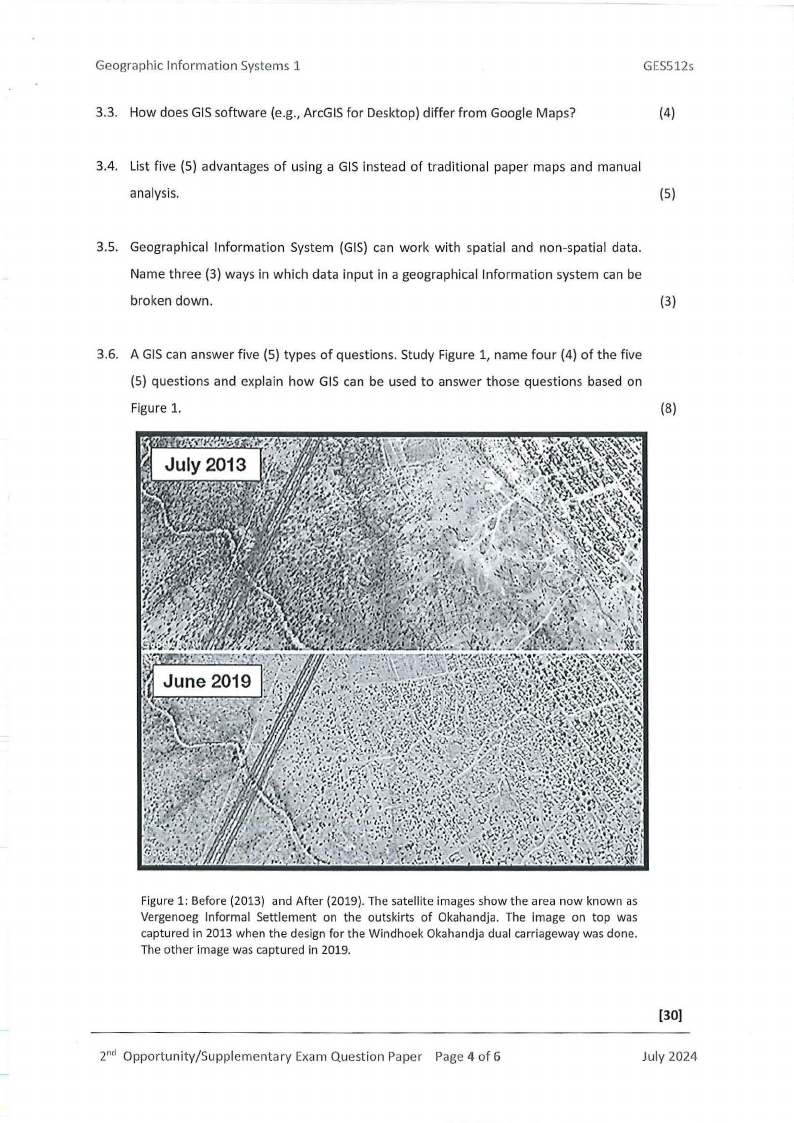
3.6. A GIS can answer five (5) types of questions. Study Figure 1, name four (4) of the five
(5) questions and explain how GIS can be used to answer those questions based on
Figure 1.
(8)
Figure 1: Before (2013) and After (2019). The satellite images show the area now known as
Vergenoeg Informal Settlement on the outskirts of Okahandja. The image on top was
captured in 2013 when the design for the Windhoek Okahandja dual carriageway was done.
The other image was captured in 2019.
2nd Opportunity/Supplementary Exam Question Paper Page 4 of 6
(30)
July 2024
|
|
5 Page 5 |
▲back to top |
Geographic Information Systems 1
GESS12s
Question4
4.1. Define the following terms.
a} Geiod
(2)
b} Ellipsoid
{2}
c} Map projection
(2)
4.2. What projection properties does a Mercator projection preserve?
(2)
4.3. What is the difference between a secant and a tangent projection?
(2)
4.4. Define and describe the UTM Coordinate System. What type of developable surface is
used for a UTM projection?
(5)
4.5. Briefly explain how a UTM zone is defined in terms of its central meridian, standard
meridian, and scale factor.
(5)
4.6. Explain the concept of utilising counts and cell values within a raster data model.
(5)
[25)
2nd Opportunity/Supplementary Exam Question Paper Page 5 of 6
July 2024
|
|
6 Page 6 |
▲back to top |
Geographic Information Systems 1
Question 5
GES512s
5.1. Outline four (4) of the problems of paper map digitisation.
(4)
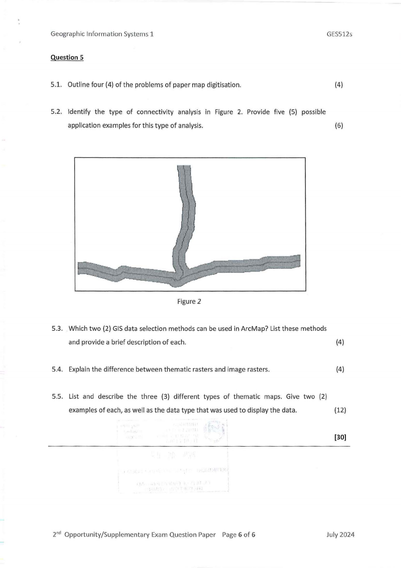
5.2. Identify the type of connectivity analysis in Figure 2. Provide five (5) possible
application examples for this type of analysis.
(6)
Figure 2
5.3. Which two (2) GIS data selection methods can be used in ArcMap? List these methods
and provide a brief description of each.
(4)
5.4. Explain the difference between thematic rasters and image rasters.
(4)
5.5. List and describe the three (3) different types of thematic maps. Give two (2)
examples of each, as well as the data type that was used to display the data.
(12)
(30]
2nd Opportunity/Supplementary Exam Question Paper Page 6 of 6
July 2024