


 |
ASP720S - APPLIED SPATIAL PLANNING- 2ND OPP- JULY 2024 |
|
|
1 Page 1 |
▲back to top |
nAmlBIA UnlVERSITY
OF SCIEnCE Ano TECHnOLOGY
FACULTYOF ENGINEERINGAND THE BUILTENVIRONMENT
DEPARTMENTOF ARCHITECTUREP, LANNINGAND CONSTRUCTION
QUALIFICATION:BACHELOR OF REGIONAL AND RURAL DEVELOPMENT
QUALIFICATIONCODE:07BRAR
LEVEL:7
COURSECODE:ASP720S
COURSENAME: APPLIED SPATIAL PLANNING
DATE: JULY 2024
PAPER:THEORY
DURATION: 3 HOURS
MARl<S:100
SECONDOPPORTUNITY/ SUPPLEMENTARYEXAMINATION QUESTION PAPER
EXAMINER(S)
MODERATOR
Dr. Laudika J Kandjinga
Ms. Rosena Mubiana
INSTRUCTIONS
1. Read the entire question paper before answering the questions.
2. Read each question carefully and address all parts of the questions.
3. Answer ALLthe questions.
4. Answers may be written in any order but must be legibly numbered.
5. Pleasewrite clearly and legibly.
6. Ensure your Student Number is on the EXAMINATIONBOOK(s).
Permissible Items: Pencil, eraser, and ruler
THIS QUESTION PAPER CONSISTS OF 4 PAGES
(Including this front page)
|
|
2 Page 2 |
▲back to top |
Applied Spatial Planning
ASP720S
QUESTION 1
(a) Spatial Planning has three broad functions. Provide self-explanatory examples of
the following three broad functions:
(I) Regulatory
(2)
(II) Coordination
(2)
(III) Development
(2)
(b) Outline eight questions to be answered (considered).when synthesising and shaping the
spatial argument through spatial Analysis.
(8)
[14]
QUESTION 2
The Stepmore Settlement Case study from South Africa provides an excellent opportunity to
understand the complexity of rural development. Similarly, it formed the basis for how rural
development complexity could be solved, including Namibia. The problem has two sides: (1)
those who wish to remain in the settlement and (2) those who would like to leave the
settlement. Based on this background, answer the following questions:
(a) Discuss the strategies employed in Stepmore Settlement geared toward the residents
who wished to remain in the settlements.
(8)
(b) In your own opinion, how could the government help those who wish to leave the
settlement, particularly the young people? Suggest at least five bullet points.
(10)
(c) Another approach introduced was establishing a trade centre at Stepmore to unlock the
settlement's potential. Discuss how the trade centre will operate as a focal point for the
development & creation of opportunities for the surrounding rural households.
(8)
[26]
QUESTION 2
(a) During community engagement, it is essential to be guided by guiding principles.
Briefly describe these principles.
(5)
(b) Regional and Constituency Offices are constrained by several factors when coordinating
line ministries to reflect local priorities for Rural Development. Discuss four of
these factors.
(9)
Second Opportunity/ Supplementary Question Paper
Page 2 of 4
July 2024
|
|
3 Page 3 |
▲back to top |
Applied Spatial Planning
ASP720S
(c) The National Rural Development Policy states that Rural development action plans shall
be developed through the existing coordinating structures (RDCC,CDCs,SDCs).Explain
the involvement of these three structures in rural development.
(6)
[20]
QUESTION 3
An Integrated Regional Land Use Plan (IRLUP)is an example of spatial planning that deals with
several Land Use aspects. IRLUPsare significant in regional planning and development. The
Ministry of Agriculture, Water and Land Reform is in the process of finalising an IRLUPfor
Region Z. Against the above, answer the following questions:
(a) Briefly describe the aims of conducting constituency workshops during the preparation
of the Integrated Regional Land Use Plan (IRLUP).
(6)
(b) The land use proposals of the IRLUPare assessed by the Strategic Environmental
Assessment {SEA)using three main criteria. Discussthese criteria.
(6)
(d) The Fortaleza River in a particular region has been born of contention between several
land uses due to competing activities, notably tourism, grazing, irrigation, and community
water absorption. The indigenous communities primarily depend on this river for
livelihood. Due to competing land use activities, this needs urgent practical and long-term
solutions, which must also benefit every competing land use activity. How will you
remedy this situation from a spatial planning perspective? In addition, support your
discussion with a self-explanatory diagram. (note 10 marks for a self-explanatory
diagram).
{18)
[30]
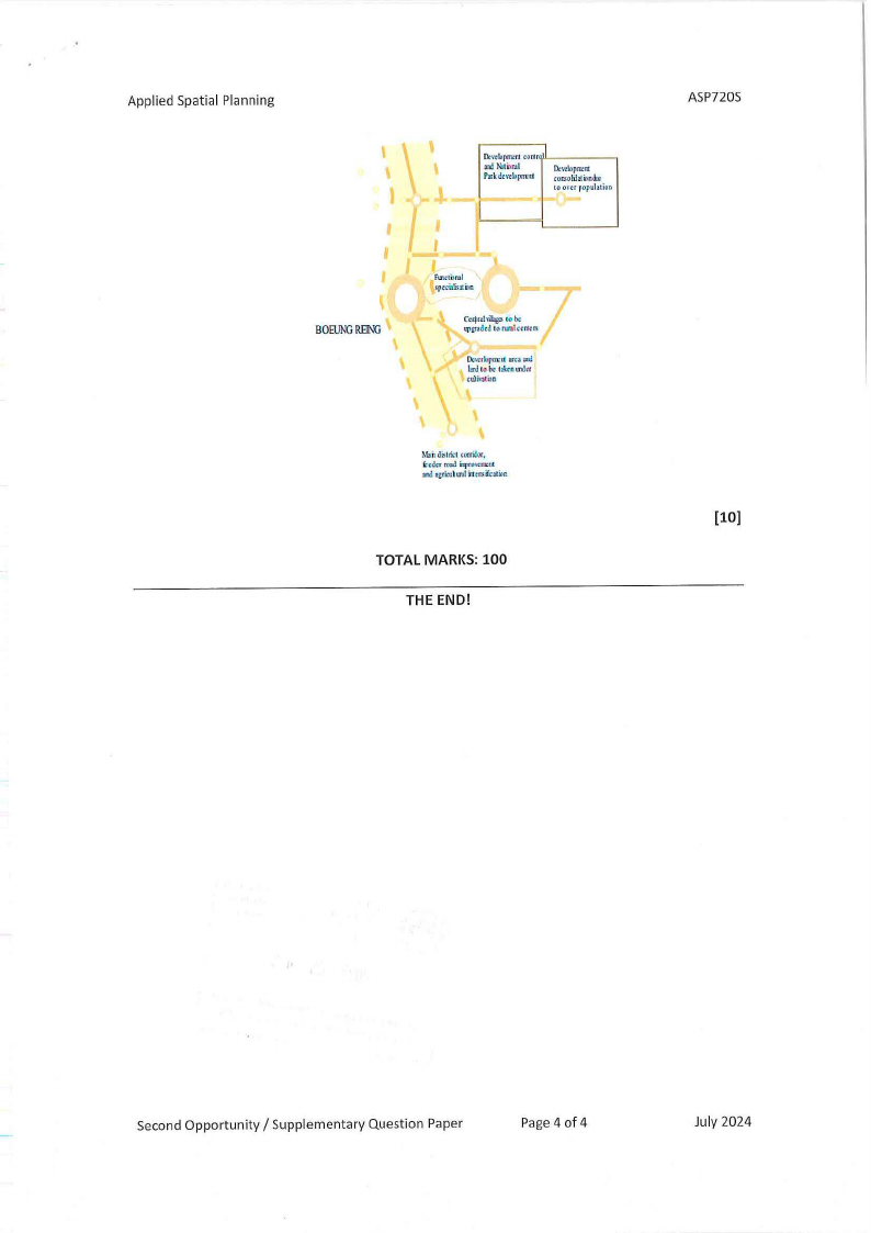
QUESTION 4
(a) How can a Regional Development Profile enhance Rural Development at the grassroots
level?
(5)
(b) Below is an example of a Spatial Diagram. How can a Spatial Diagram help a Region and
Rural Development?
(5)
Second Opportunity/ Supplementary Question Paper
Page 3 of 4
July 2024
|
|
4 Page 4 |
▲back to top |
Applied Spatial Planning
I'
BOEUNRGEING
''J.
~,tkipmw cor.tr"'''~----
ani Nilnml
Pa,ldt,-cloprrett
l).,,~~pmtrt
tonsolihlimilr
to onr popuhtion
''
Fmcti:iro\\
ircchz:rtim
7
C<rjrthili;:,:s10 be
q,gndtd 10 rw1lccr.trn:
\\
\\
\\
\\
n:.mbpm:"liarcsm!
!in!to be tm'n mkr
cW.r\\"Jlian
\\
~bhdis1B:t corri.!oc.
i:td(r road Ellfo\\tm:tt
loo.egriru\\l111itc.r,:ifrtliln
TOTAL MARKS: 100
THE END!
ASP720S
[10]
Second Opportunity/ Supplementary Question Paper
Page 4 of 4
July 2024
|
|
5 Page 5 |
▲back to top |
nAmlBIA UnlVERSITY
OF SCIEnCEAno TECHnOLOGY
FACULTYOF ENGINEERINGAND THE BUILT ENVIRONMENT
DEPARTMENTOF ARCHITECTUREP, LANNING AND CONSTRUCTION
QUALIFICATION:BACHELOROF REGIONALAND RURALDEVELOPMENT
QUALIFICATION CODE: 07BRAR
LEVEL:7
COURSECODE:ASP720S
COURSENAME: APPLIEDSPATIALPLANNING
DATE: JUNE 2024
PAPER:THEORY
DURATION: 3 HOURS
MARKS: 100
EXAMINER(S)
MODERATOR
FIRSTOPPORTUNITYEXAMINATION QUESTION PAPER
Dr. Laudika J Kandjinga
Ms. Rosena Mubiana
INSTRUCTIONS
1. Read the entire question paper before answering the questions.
2. Read each question carefully and address all parts of the questions.
3. Answer ALLthe questions.
4. Answers may be written in any order but must be legibly numbered.
5. Pleasewrite clearly and legibly.
6. Ensureyour Student Number is on the EXAMINATIONBOOK(s).
Permissible Items: Pencil, eraser, and ruler
THIS QUESTION PAPERCONSISTSOF 3 PAGES
(Including this front page)
|
|
6 Page 6 |
▲back to top |
Applied Spatial Planning
ASP720S
QUESTION 1
(a) Explain the importance of Spatial Planning for Regional/ Rural Development.
(5)
(b) In your own opinions, how would you describe Spatial Planning?
(2)
(c) Spatial Planning was introduced for several reasons. Explain how the following
necessitated the introduction of Spatial Planning:
(i) Fragmentation.
(2)
(j) Rising environmental concerns.
(2)
(k) Uneven distribution of investment created many problems.
(3)
(d) List six (6) stages of conducting Physical and Environmental Analysis.
(6)
(e) Discussthe following spatial analysis techniques in detail. In addition, provide an example
of each technique:
(i) Space Economy Analysis.
(3)
(ii) Settlement Analysis.
(5)
(iii) Accessibility Analysis.
(7)
(iv) Functional Analysis.
(3)
[38]
QUESTION 2
(a) Briefly outline ten points why involving the community in spatial planning and
development activities is essential.
(10)
(b) The main argument of South Africa's National Spatial Development Framework (NSDF) is
to pinpoint areas of 'potential' / comparative advantage for priorities in resource
allocation (e.g., infrastructure funding). Describe five criteria for identifying the
potential of an area (you may provide an example for each).
(10)
(c) The Ministry of Urban and Rural Development coordinates Rural Development. Explain
the following in terms of coordination:
(i) Integrated planning.
(2)
(ii) Collaborative implementation
(3)
First Opportunity Question Paper
Page 2 of 3
June 2024
|
|
7 Page 7 |
▲back to top |
Applied Spatial Planning
ASP720S
(iii) Joint monitoring and evaluation
(3)
(iv) InstitutionalRearrangement and CapacityDevelopment
(3)
(v) ResourcesMobilizationand Rea/location
(2)
(33]
QUESTION 3
An Integrated Regional Land Use Plan (IRLUP)is an example of spatial planning that deals with
several Land Use aspects. IRLUPs are significant in regional planning and development. The
Ministry of Agriculture, Water and Land Reform is in the process of finalising an IRLUP for
Region Z. Against the above, answer the following questions:
(a) During the constituency workshop, the community identified several competing land
uses, notably, "Settlement versus Craping& livestock". Using bullets, propose at least
four (4) possible solutions to these competing land uses.
(4)
(b) The Fortaleza River in a particular region has been born of contention between several
land uses due to competing activities, notably tourism, fishing, grazing, irrigation, and
community water absorption. The indigenous communities primarily depend on this
river for livelihood. Due to competing land use activities, this needs urgent practical and
long-term solutions, which must also benefit every competing land use activity. How
will you remedy this situation from a spatial planning perspective? In addition, support
your discussion with a self-explanatory diagram. (note 15 marksfor a self-explanatory
diagram).
(25)
(29]
TOTAL MARKS: 100
THE END!
First Opportunity Question Paper
Page3 of 3
June 2024