


 |
BSV521S - BASIC SURVEYING - 1ST OPP - JUNE 2022 |
|
|
1 Page 1 |
▲back to top |
nAm I 8 I A un IVERS ITV
OF SCIEnCE Ano TECHnOLOGY
FACULTYOF ENGINEERINGAND SPATIALSCIENCES
DEPARTMENTOF ARCITECTUREAND SPATIALSCIENCES
QUALIFICATIONS:
BACHELOROF GEOMATICS and DIPLOMA IN GEOMATICS
QUALIFICATIONSCODES:
07BGEO,06DGEO
QUALIFICATION LEVEL:
Level 7 - 07BGEO
Level 6 - 06DGEO
COURSECODE: BSV521
COURSENAME: Basic Surveying
DATE: June 2022
PAPER:THEORY
DURATION: 3 HOURS
MARKS: 100
EXAMINER:
MODERATOR:
FIRSTOPPORTUNITYEXAMINATION QUESTIONPAPER
Mr F. J. Louw
Mr S. Sinvula
INSTRUCTIONS
1. You MUST answer ALLQUESTIONS
2. Write clearly and neatly.
3. Number the answers clearly.
4. Make sure your Student Number is on the EXAMINATION BOOK(s).
5. MAKE SUREYOUR STUDENTNUMBER IS ON THE DATA SHEETAND
THAT YOU SUBMIT IT WITH YOUR EXAMINATION BOOK(S).
PERMISSIBLEMATERIALS
1. Calculator, ruler, pencil and eraser.
THIS QUESTION PAPERCONSISTSOF 7 PAGES(Including this front page and 1 Data Sheet)
|
|
2 Page 2 |
▲back to top |
Basic Surveying
BSV521S
Question 1
1.1. Differentiate between a Measurement and an Observation.
(4)
1.2. Distinguish between "Zero south orientation" and "True orientation".
(4)
1.3. To carry out a survey one needs to consider certain principle factors before executing the survey,
describe ALLthese principle factors.
(5)
1.4. How would you test for the presence of parallax in the telescope of a theodolite?
(2)
[15]
Question 2
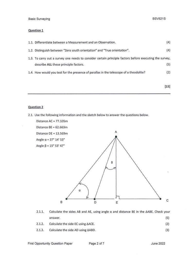
2.1. Use the following information and the sketch below to answer the questions below.
Distance AC= 77.105m
Distance BE = 62.663m
Distance DE= 13.569m
A
Angle a= 37° 14' 53"
Angle p = 15° 53' 47"
B
D
E
C
2.1.1.
2.1.2.
2.1.3.
Calculate the sides AB and AE, using angle a and distance BE in the t.ABE. Check your
answer.
(5)
Calculate the side ECusing t.ACE.
(2)
Calculate the side AD using t.ABD.
(3)
First Opportunity Question Paper
Page 2 of?
June 2022
|
|
3 Page 3 |
▲back to top |
Basic Surveying
BSV521S
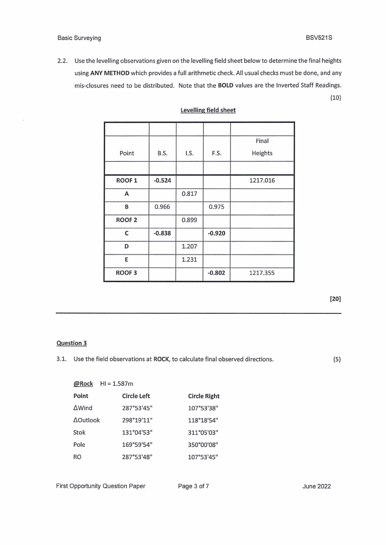
2.2. Use the levelling observations given on the levelling field sheet below to determine the final heights
using ANY METHODwhich provides a full arithmetic check. All usual checks must be done, and any
mis-closures need to be distributed. Note that the BOLDvalues are the Inverted Staff Readings.
(10)
Levelling field sheet
Point
B.S.
I.S.
F.S.
Final
Heights
ROOFl
A
B
ROOF2
C
D
E
ROOF3
-0.524
0.966
-0.838
0.817
0.899
1.207
1.231
0.975
-0.920
-0.802
1217.016
1217.355
[20]
Question 3
3.1. Use the field observations at ROCK, to calculate final observed directions.
@Rock HI= 1.587m
Point
Circle Left
/::,.Wind
287°53'45"
/::,.Outlook
298°19'11"
Stok
131°04'53"
Pole
169°59'54"
RO
287°53'48"
Circle Right
107°53'38"
118°18'54"
311•05•03"
350°00'08"
107°53'45"
First Opportunity Question Paper
Page 3 of7
(5)
June 2022
|
|
4 Page 4 |
▲back to top |
Basic Surveying
BSV521S
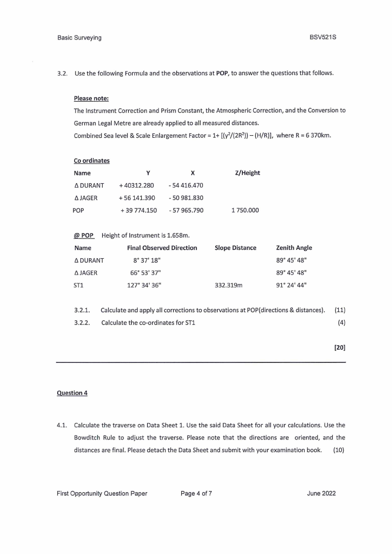
3.2. Use the following Formula and the observations at POP, to answer the questions that follows.
Please note:
The Instrument Correction and Prism Constant, the Atmospheric Correction, and the Conversion to
German Legal Metre are already applied to all measured distances.
Combined Sea level & Scale Enlargement Factor= 1+ [(y2/(2R2))- (H/R)], where R = 6 370km.
Co ordinates
Name
t:,.DURANT
/::,.JAGER
POP
y
+ 40312.280
+ 56141.390
+ 39 774.150
X
- 54 416.470
- so981.830
-57 965.790
Z/Height
1 750.000
@ POP Height of Instrument is 1.658m.
Name
Final Observed Direction
t:,.DURANT
8° 37' 18"
/::,.JAGER
sn
66° 53' 37"
127° 34' 36"
Slope Distance
332.319m
Zenith Angle
89° 45' 48"
89° 45' 48"
91°24'44"
3.2.1. Calculate and apply all corrections to observations at POP(directions & distances). (11)
3.2.2. Calculate the co-ordinates for ST1
(4)
[20)
Question 4
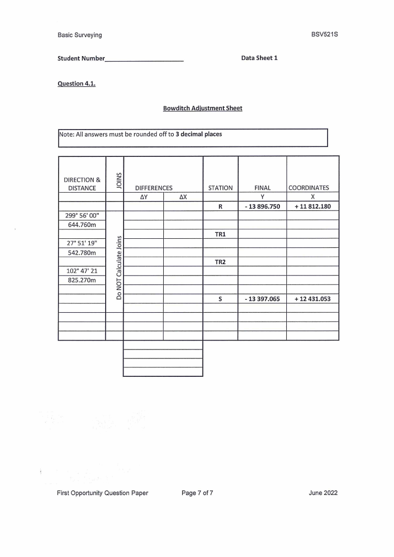
4.1. Calculate the traverse on Data Sheet 1. Use the said Data Sheet for all your calculations. Use the
Bowditch Rule to adjust the traverse. Please note that the directions are oriented, and the
distances are final. Please detach the Data Sheet and submit with your examination book. (10)
First Opportunity Question Paper
Page 4 of7
June 2022
|
|
5 Page 5 |
▲back to top |
Basic Surveying
BSV521S
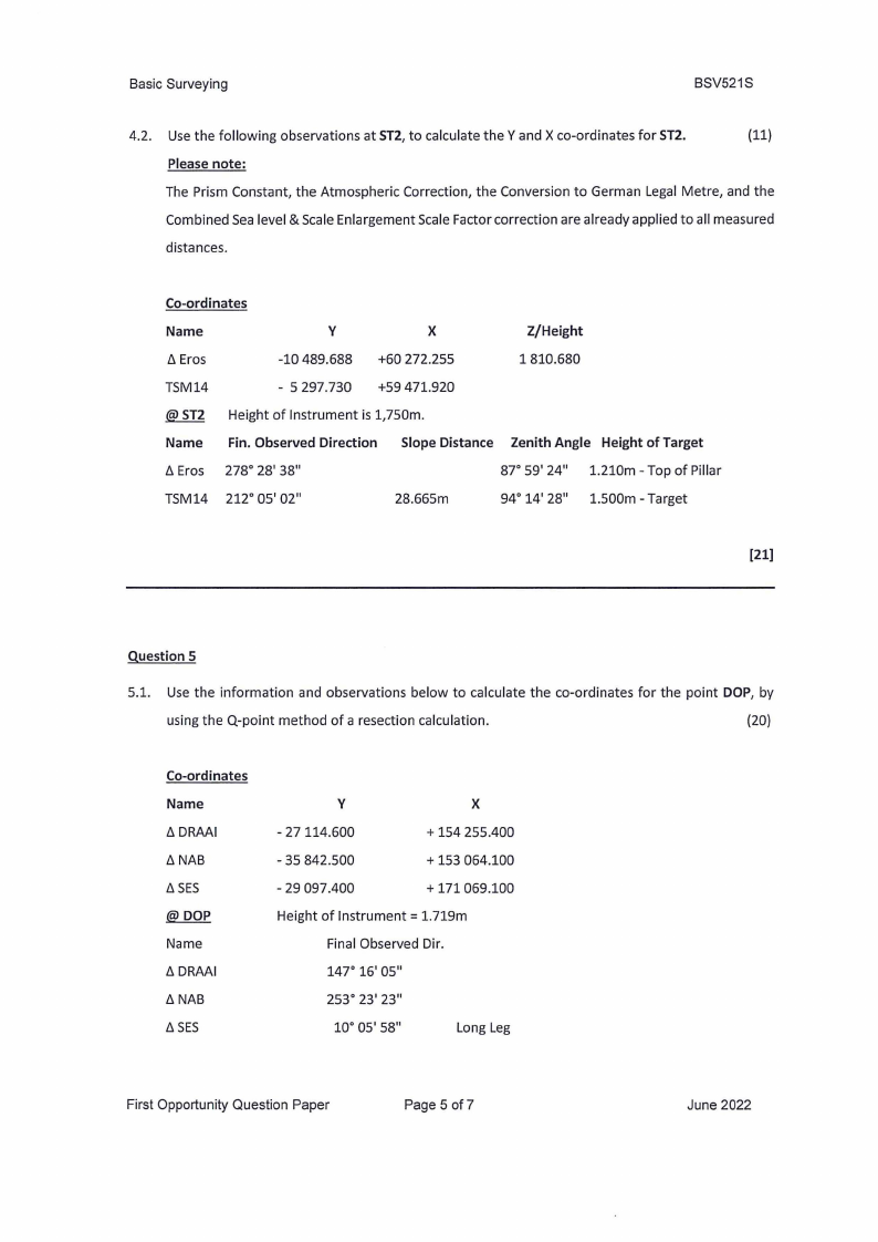
4.2. Use the following observations at ST2, to calculate the Y and X co-ordinates for ST2.
(11)
Please note:
The Prism Constant, the Atmospheric Correction, the Conversion to German Legal Metre, and the
Combined Sea level & Scale Enlargement Scale Factor correction are already applied to all measured
distances.
Co-ordinates
Name
y
X
Z/Height
/J.Eros
-10 489.688 +60 272.255
1810.680
TSM14
- 5 297.730 +59 471.920
@ ST2 Height of Instrument is 1,750m.
Name Fin. Observed Direction Slope Distance Zenith Angle Height of Target
/J.Eros 278° 28' 38"
87° 59' 24" 1.210m - Top of Pillar
TSM14 212° 05' 02"
28.665m
94° 14' 28" 1.500m - Target
(21)
Question 5
5.1. Use the information and observations below to calculate the co-ordinates for the point DOP, by
using the Q-point method of a resection calculation.
(20)
Co-ordinates
Name
/J.DRAAI
/J.NAB
/J.SES
@DOP
Name
/J.DRAAI
/J.NAB
/J.SES
y
X
- 27114.600
+ 154 255.400
- 35 842.500
+ 153 064.100
- 29 097.400
+ 171 069.100
Height of Instrument= 1.719m
Final Observed Dir.
147° 16' 05"
253° 23' 23"
10° 05' 58"
Long Leg
First Opportunity Question Paper
Page 5 of 7
June 2022
|
|
6 Page 6 |
▲back to top |
Basic Surveying
BSV521S
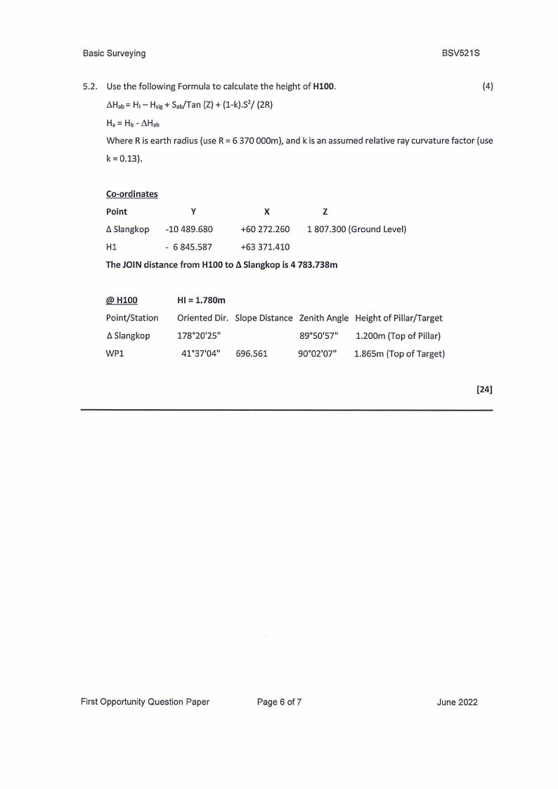
5.2. Use the following Formula to calculate the height of HlOO.
(4)
LlHab= H1- H5;g + Sab/Tan (Z)+ (1-k).$2/ (2R)
Ha= Hb- LlHab
Where R is earth radius (use R = 6 370 000m), and k is an assumed relative ray curvature factor (use
k = 0.13).
Co-ordinates
Point
Y
X
z
6 Slangkop -10 489.680
+60 272.260 1 807.300 (Ground Level)
Hl
- 6 845.587
+63 371.410
The JOIN distance from HlOO to fl Slangkop is 4 783.738m
@HlOO
Point/Station
fl Slangkop
WP1
HI= 1.780m
Oriented Dir. Slope Distance Zenith Angle Height of Pillar/Target
178°20'25"
89°50'57" 1.200m (Top of Pillar)
41 °37'04" 696.561
90°02'07" 1.865m (Top of Target)
[24)
First Opportunity Question Paper
Page 6 of 7
June 2022
|
|
7 Page 7 |
▲back to top |
Basic Surveying
Student Number _________
_
Data Sheet 1
Question 4.1.
Bowditch Adjustment Sheet
Note: All answers must be rounded off to 3 decimal places
BSV521S
DIRECTION&
DISTANCE
299° 56' 00"
644.760m
27° 51' 19"
542.780m
102° 47' 21
825.270m
zVl
-0,
DIFFERENCES
t::.Y
t::.X
Vl
C
-0,
.C.J..,
::J
J:!
ucu
f-
0z
0
0
STATION
R
FINAL
y
-13 896.750
COORDINATES
X
+ 11812.180
TRl
TR2
s
-13 397.065
+ 12 431.053
First Opportunity Question Paper
Page 7 of7
June 2022