


 |
BSV521S - BASIC SURVEYING - 1ST OPP - JUNE 2024 |
|
|
1 Page 1 |
▲back to top |
nAmlBIA unlVERSITY
OFSCIEnCEAno TECHno LOGY
FACULTY OF ENGINEERING AND THE BUILT ENVIRONMENT
DEPARTMENTOF LAND AND SPATIALSCIENCES
QUALIFICATIONS:
BACHELOROF GEOMATICS and DIPLOMA IN GEOMATICS
QUALIFICATIONSCODES:
07BGEO, 06DGEO
QUALIFICATION LEVEL:
Level 7 - 07BGEO
Level 6 - 06DGEO
COURSENAME: Basic Surveying
COURSECODE:BSV521S
COURSELEVEL:5
DATE: June 2024
PAPER:THEORY
DURATION: 3 HOURS
MARKS: 100
EXAMINER:
MODERATOR:
FIRSTOPPORTUNITYEXAMINATION QUESTION PAPER
Mr F. J. Louw
Mr S. Sinvula
INSTRUCTIONS
1. You MUST answer ALLQUESTIONS
2. Write clearly and neatly.
3. Number the answers clearly.
4. Make sure your Student Number is on the EXAMINATION BOOK(s}.
5. MAKE SUREYOUR STUDENTNUMBER IS ON ALLTHE DATA SHEETSAND
THAT YOU SUBMIT THEM WITH YOUR EXAMINATION BOOK(S).
PERMISSIBLEMATERIALS
1. Calculator, ruler, pen, pencil, and eraser.
THIS QUESTION PAPERCONSISTSOF 7 PAGES(Including this front page and 2 Data Sheets}
|
|
2 Page 2 |
▲back to top |

Basic Surveying
BSV521S
Question 1
1.1. Distinguish between the terms Error and Correction.
(2)
1.2. Briefly describe the term "Barometric Levelling".
(2)
1.3. List the TWO Principal Classifications of Surveying. Wh~t is the main difference between these
Principal Classifications of Surveying?
(4)
1.4. How wide is one belt (degrees) in the Namibian coordinate system?
(1)
1.5. What do you understand by the term "Zero South Orientation" of a Theodolite or a Total Station?
{2)
Question 2
2.1. Use the information below to calculate MEAN co-ordinates for point ST1.
{15)
Co-ordinates
Name
y
X
A
+ 51 786.365
+ 58 429.857
B
+ 52 987.953
+ 59 199.901
Angle a = 127° 43' 42"
Angle = 4° 21' 49"
Final Reduced Horizontal Distances:
A to ST1 = 1521.120m
A
B to ST1 = 146.330m
ST1
B
First Opportunity Question Paper
Page 2 of 7
June 2024
|
|
3 Page 3 |
▲back to top |
Basic Surveying
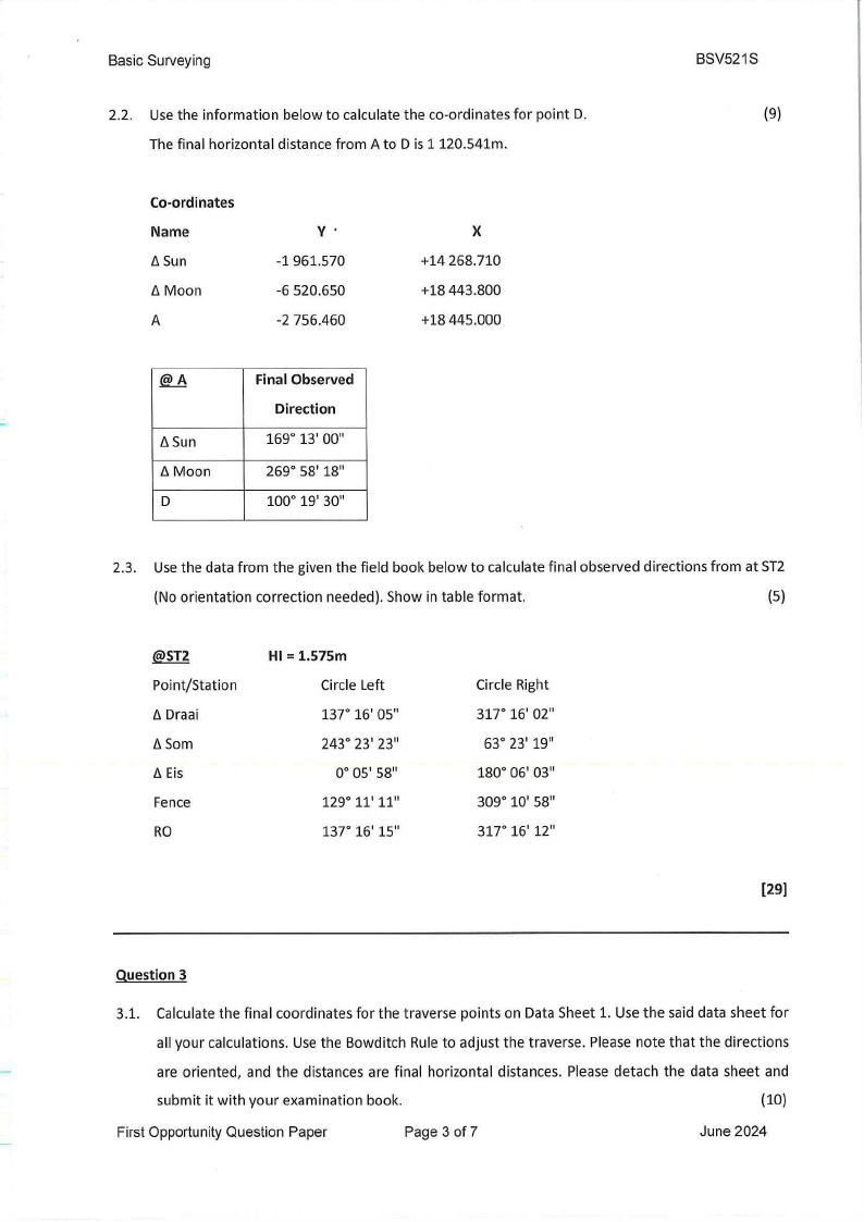
2.2. Use the information below to calculate the co-ordinates for point D.
The final horizontal distance from A to D is 1120.541m.
Co-ordinates
Name
6 Sun
6 Moon
A
v·
-1 961.570
-6 520.650
-2 756.460
X
+14 268.710
+18 443.800
+18 445.000
@..8
6 Sun
ti Moon
D
Final Observed
Direction
169° 13' 00"
269° 58' 18"
100° 19' 30"
BSV521S
(9)
2.3. Use the data from the given the field book below to calculate final observed directions from at ST2
(No orientation correction needed). Show in table format.
(5)
@ST2
Point/Station
6 Draai
6 Som
6 Eis
Fence
RO
HI= 1.575m
Circle Left
137° 16' 05"
243° 23' 23"
0° 05' 58"
129° 11' 11"
137° 16' 15"
Circle Right
317° 16' 02"
63° 23' 19"
180° 06' 03"
309° 10' 58"
317° 16' 12"
[29)
Question 3
3.1. Calculate the final coordinates for the traverse points on Data Sheet 1. Use the said data sheet for
all your calculations. Use the Bowditch Rule to adjust the traverse. Please note that the directions
are oriented, and the distances are final horizontal distances. Please detach the data sheet and
submit it with your examination book.
(10)
First Opportunity Question Paper
Page 3 of 7
June 2024
|
|
4 Page 4 |
▲back to top |
Basic Surveying
BSV521S
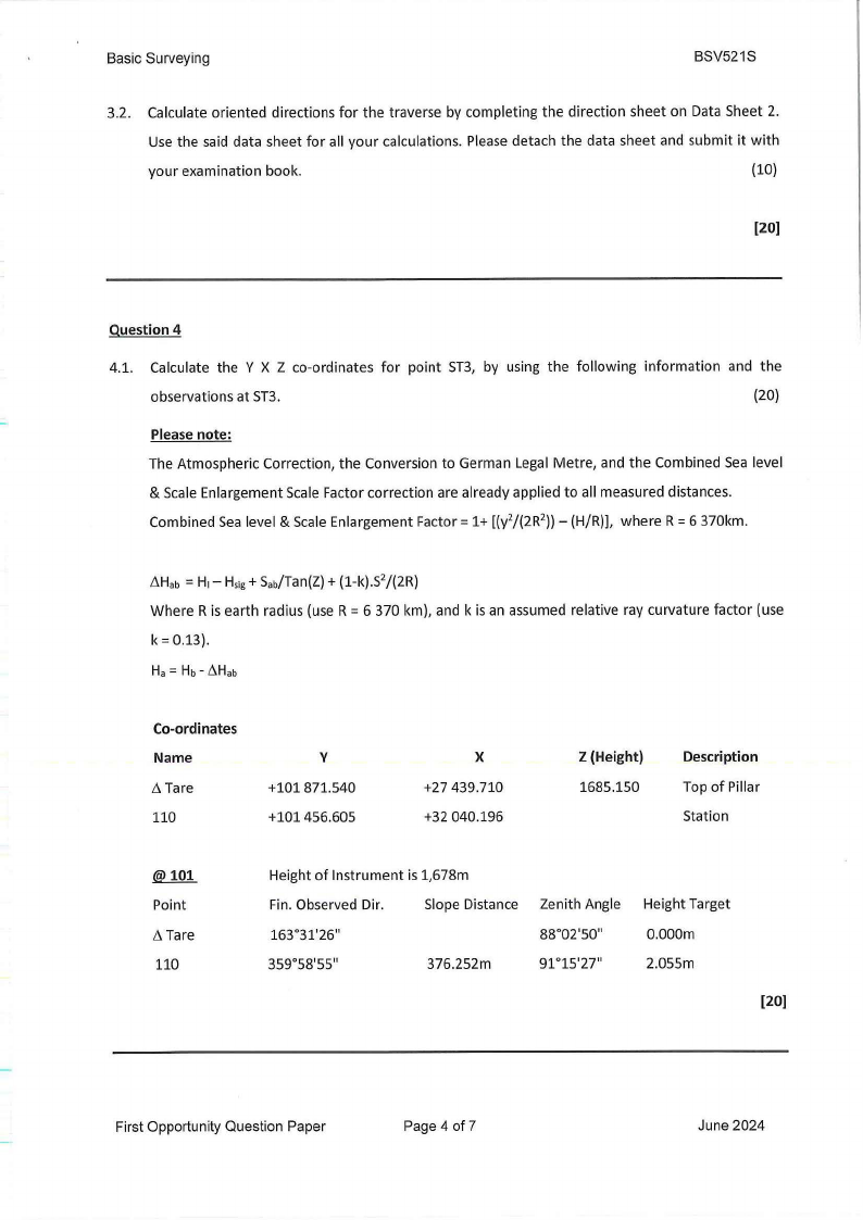
3.2. Calculate oriented directions for the traverse by completing the direction sheet on Data Sheet 2.
Use the said data sheet for all your calculations. Please detach the data sheet and submit it with
your examination book.
(10)
(20)
Question 4
4.1. Calculate the Y X Z co-ordinates for point ST3, by using the following information and the
observations at ST3.
(20)
Please note:
The Atmospheric Correction, the Conversion to German Legal Metre, and the Combined Sea level
& Scale Enlargement Scale Factor correction are already applied to all measured distances.
Combined Sea level & Scale Enlargement Factor= 1+ [(y2/(2R2))-(H/R)], where R = 6 370km.
~Hab = H1- Hsig+ Sab/Tan(Z)+ (1-k).s2/(2R)
Where R is earth radius (use R = 6 370 km), and k is an assumed relative ray curvature factor (use
k = 0.13).
Ha= Hb- ~Hab
Co-ordinates
Name
Tare
110
y
+101871.540
+101456.605
X
+27 439.710
+32 040.196
Z (Height)
1685.150
Description
Top of Pillar
Station
@101
Point
Tare
110
Height of Instrument is 1,678m
Fin. Observed Dir.
Slope Distance
163°31'26"
359°58'55"
376.252m
Zenith Angle
88°02'50"
91 °15'27"
Height Target
0.000m
2.055m
(20]
First Opportunity Question Paper
Page 4 of 7
June 2024
|
|
5 Page 5 |
▲back to top |
Basic Surveying
BSV521S
Question 5
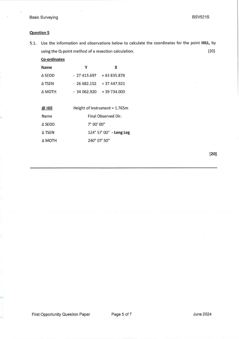
5.1. Use the information and observations below to calculate the coordinates for the point HILL, by
using the Q-point method of a resection calculation.
(20)
Co-ordinates
Name
y
X
b.SEOD
- 27 413.697 + 43 835.878
b. TSEN
- 26 682.152 + 37 447.921
b.MOTH
- 34 062.920 + 39 734.000
.@J:llil
Name
b.SEOD
b. TSEN
b.MOTH
Height of Instrument= 1.765m
Final Observed Dir.
7° 00' 00"
124° 57' 00" • LongLeg
240° 07' 50"
[20)
First Opportunity Question Paper
Page 5 of7
June 2024
|
|
6 Page 6 |
▲back to top |

Basic Surveying
Student Number________
_
Question 2.1.
Bowditch Adjustment Sheet
Note: All answers must be rounded off to 3 decimal places
BSV521S
Data Sheet 1
DIRECTION& zV)
DISTANCE 0-,
DIFFERENCES
{j,y
{j,X
299° 56' 00"
644.760m
Ill
27° 51' 19"
·oC:
-,
542.780m
.<.L..I .
.!!!
::i
102° 47' 21
uro
I-
825.270m
0z
0
C)
STATION
R
TRl
TR2
s
FINAL
y
-13 896.750
-13 397.065
COORDINATES
X
+ 11812.180
+ 12 431.053
First Opportunity Question Paper
Page 6 of 7
June 2024
|
|
7 Page 7 |
▲back to top |
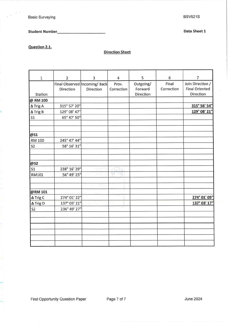
Basic Surveying
Student Number ________
Question 2.1.
_
Direction Sheet
BSV521S
Data Sheet 1
1
Station
@ RM 100
fl Trig A
fl Trig B
S1
2
3
4
Final Observed Incoming/ Back Prov.
Direction
Direction Correction
315° 57' 20"
129° 08' 47"
65° 47' 50"
5
Outgoing/
Forward
Direction
6
Final
Correction
7
Join Direction /
Final Oriented
Direction
315° 56' 54"
129° 08' 21"
@Sl
RM 100
S2
245° 47' 44"
58° 16' 31"
@S2
S1
RM101
238° 16' 29"
56° 49' 25"
@RM 101
fl Trig C
fl Trig D
S2
274° 01' 22"
137° 03' 21"
236° 49' 27"
. i.
"
I
I
274° 01' 09"
137° 03' 17"
First Opportunity Question Paper
Page 7 of 7
June 2024