


 |
BSV521S - BASIC SURVEYING - 2ND OPP - JULY 2024 |
|
|
1 Page 1 |
▲back to top |
nAmlBIA unlVERSITY
OF SCIEnCE Ano TECHnOLOGY
FACULTYOF ENGINEERINGAND THE BUILTENVIRONMENT
DEPARTMENTOF LANDAND SPATIALSCIENCES
QUALIFICATIONS:
BACHELOROF GEOMATICS and DIPLOMA IN GEOMATICS
QUALIFICATIONSCODES:
07BGEO,06DGEO
QUALIFICATIONLEVEL:
Level 7 - 07BGEO
Level 6 - 06DGEO
COURSENAME: Basic Surveying
COURSECODE:BSV521S
COURSELEVEL:5
DATE: July 2024
PAPER:THEORY
DURATION: 3 HOURS
MARKS: 100
SECONDOPPORTUNITY/SUPPLEMENTARYEXAMINATION QUESTION PAPER
EXAMINER:
Mr F. J. Louw
MODERATOR:
Mr S. Sinvula
INSTRUCTIONS
1. You MUST answer ALLQUESTIONS
2. Write clearly and neatly.
3. Number the answers clearly.
4. Make sure your Student Number is on the EXAMINATION BOOK(s}.
5. MAKE SUREYOUR STUDENTNUMBER IS ON ALLTHE DATA SHEETSAND
THAT YOU SUBMIT THEM WITH YOUR EXAMINATION BOOK(S).
PERMISSIBLEMATERIALS
1. Calculator, ruler, pen, pencil, and eraser.
THIS QUESTION PAPERCONSISTSOF 7 PAGES(Including this front page and 3 Data Sheets}
|
|
2 Page 2 |
▲back to top |
Basic Surveying
BSV521S
Question 1
1.1. Briefly explain the FOUR important aspects of a resection.
(4)
1.2. To carry out a survey one needs to consider certain principle factors before executing the survey,
describe ALLthese principle factors.
(5)
1.3. Setting out is the process of using surveying equipment and techniques to transfer information from
a plan to the ground. Describe the THREEdistinct elements of setting out.
(3)
1.4. Describe ANY THREEqualities of a surveyor.
(3)
(15)
Question 2
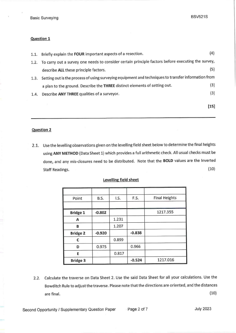
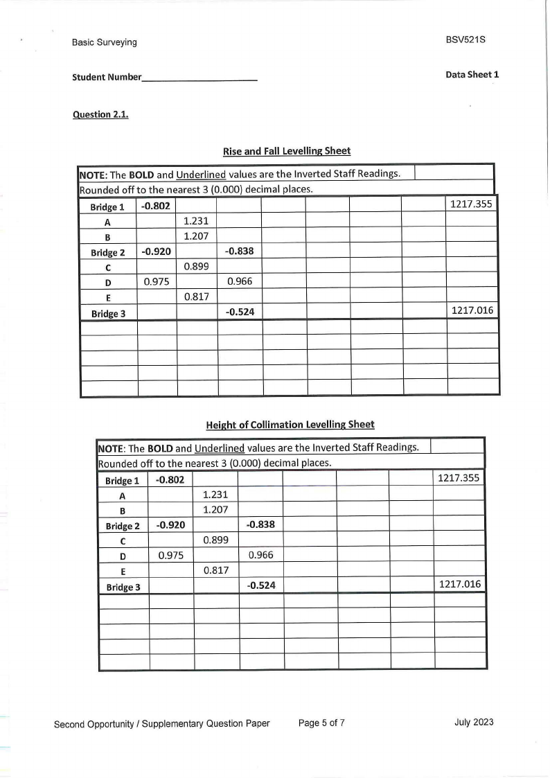
2.1. Use the levelling observations given on the levelling field sheet below to determine the final heights
using ANY METHOD (Data Sheet 1) which provides a full arithmetic check. All usual checks must be
done, and any mis-closures need to be distributed. Note that the BOLD values are the Inverted
Staff Readings.
(10)
Levellingfield sheet
Point
B.S.
1.5.
F.S.
Bridge 1
A
B
Bridge 2
C
D
E
Bridge 3
-0.802
-0.920
0.975
1.231
1.207
0.899
0.817
-0.838
0.966
-0.524
Final Heights
1217.355
1217.016
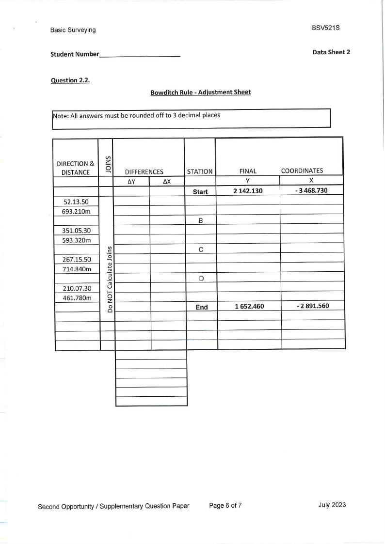
2.2. Calculate the traverse on Data Sheet 2. Use the said Data Sheet for all your calculations. Use the
Bowditch Rule to adjust the traverse. Please note that the directions are oriented, and the distances
are final.
(10)
Second Opportunity / Supplementary Question Paper
Page 2 of 7
July 2023
|
|
3 Page 3 |
▲back to top |
Basic Surveying
BSV521S
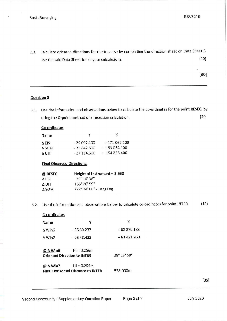
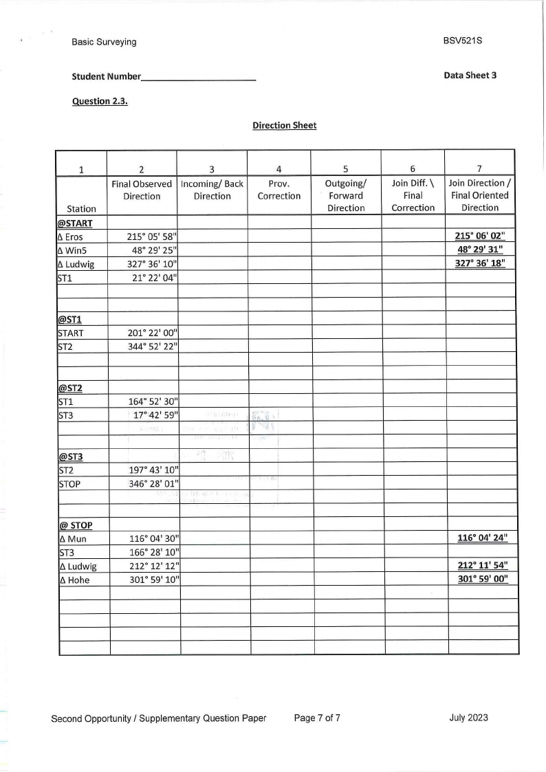
2.3. Calculate oriented directions for the traverse by completing the direction sheet on Data Sheet 3.
Use the said Data Sheet for all your calculations.
(10)
[30)
Question 3
3.1. Use the information and observations below to calculate the co-ordinates for the point RESEC,by
using the Q-point method of a resection calculation.
(20)
Co-ordinates
Name
6 EIS
6SOM
ti UIT
y
- 29 097.400
- 35 842.500
- 27114.600
X
+ 171069.100
+ 153 064.100
+ 154 255.400
Final Observed Directions.
@ RESEC
6 EIS
6 UIT
6SOM
Height of Instrument= 1.650
29° 16' 36"
166° 26' 59"
272° 34' 0611 - Long Leg
3.2. Use the information and observations below to calculate co-ordinates for point INTER.
Co-ordinates
Name
6Win6
6Win7
y
- 96 60.237
- 95 48.422
X
+ 62 379.183
+ 63 421.960
@fl. Win6
HI= 0.256m
Oriented Direction to INTER
@fl. Win7
HI= 0.256m
Final Horizontal Distance to INTER
28° 13' 5911
528.000m
(15)
[35)
Second Opportunity / Supplementary Question Paper
Page 3 of 7
July 2023
|
|
4 Page 4 |
▲back to top |
Basic Surveying
BSV521S
Question 4
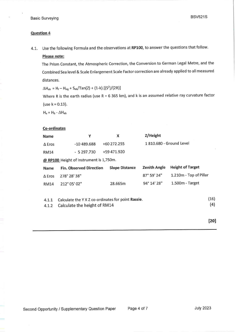
4.1. Use the following Formula and the observations at RPl00, to answer the questions that follow.
Please note:
The Prism Constant, the Atmospheric Correction, the Conversion to German Legal Metre, and the
Combined Sea level & Scale Enlargement Scale Factor correction are already applied to all measured
distances.
~Hab= H1- Hsig+ Sab/Tan(Z)+ (1-k).[(S2)/(2R)]
Where R is the earth radius (use R = 6 365 km), and k is an assumed relative ray curvature factor
(use k = 0.13).
Co-ordinates
Name
/J. Eros
RM14
V
-10 489.688
- 5 297.730
X
+60 272.255
+59 471.920
@ RPl00 Height of Instrument is 1,750m.
Name Fin. Observed Direction Slope Distance
/J.Eros 278° 28' 38"
RM14 212° 05' 02"
28.665m
2/Height
1 810.680 - Ground Level
Zenith Angle
87° 59' 24"
94° 14' 28"
Height of Target
1.210m - Top of Pillar
1.500m - Target
4.1.1 Calculate the Y X Z co-ordinates for point Rassie.
(16)
4.1.2 Calculate the height of RM14
(4)
[20]
Second Opportunity / Supplementary Question Paper
Page 4 of 7
July 2023
|
|
5 Page 5 |
▲back to top |
Basic Surveying
Student Number ________
_
BSV521S
Data Sheet 1
Question 2.1.
Rise and Fall LevellingSheet
I NOTE:The BOLDand Underlined values are the Inverted Staff Readings.
Rounded off to the nearest 3 (0.000) decimal places.
Bridge 1
A
B
Bridge 2
C
D
E
Bridge 3
-0.802
-0.920
0.975
1.231
1.207
0.899
0.817
-0.838
0.966
-0.524
1217.355
1217.016
Height of Collimation LevellingSheet
l NOTE:The BOLDand Underlined values are the Inverted Staff Readings.
Rounded off to the nearest 3 (0.000) decimal places.
Bridge 1 -0.802
1217.355
A
B
Bridge 2
-0.920
1.231
1.207
-0.838
C
0.899
D
0.975
0.966
E
Bridge 3
0.817
-0.524
1217.016
Second Opportunity/ Supplementary Question Paper
Page 5 of 7
July 2023
|
|
6 Page 6 |
▲back to top |
Basic Surveying
Student Number ________
_
Question 2.2.
Bowditch Rule - Adjustment Sheet
Note: All answers must be rounded off to 3 decimal places
BSV521S
Data Sheet 2
DIRECTION&
DISTANCE
V)
z
6..... DIFFERENCES
IW
b.X
52.13.50
693.210m
351.05.30
593.320m
VI
C:
267.15.50
.0....
714.840m
.Q.).,
.!!!
::::,
210.07.30
uC1l
I-
461.780m
0z
0
Cl
STATION
Start
B
C
D
End
FINAL
y
2142.130
1652.460
COORDINATES
X
- 3 468.730
- 2 891.560
Second Opportunity / Supplementary Question Paper
Page 6 of 7
July 2023
|
|
7 Page 7 |
▲back to top |
Basic Surveying
Student Number ________
Question 2.3.
_
Direction Sheet
BSV521S
Data Sheet 3
1
Station
®START
/j, Eros
[j,Win5
/j, Ludwig
STl
2
Final Observed
Direction
3
Incoming/ Back
Direction
4
Prov.
Correction
215° 05' 58"
48° 29' 25"
327° 36' 10"
21° 22' 04"
5
Outgoing/
Forward
Direction
6
Join Diff. \\
Final
Correction
7
Join Direction/
Final Oriented
Direction
215° 06' 02"
48° 29' 31"
327° 36' 18"
@>ST1
START
ST2
201° 22' 00"
344° 52' 22"
@ST2
STl
ST3
@ST3
ST2
STOP
® STOP
/j, Mun
ST3
/j, Ludwig
/j, Hohe
164° 52' 30"
17°42' 59"
I
'
\\
197° 43' 10"
346° 28' 01"
"
-· :. '
I
,,.
116° 04' 30"
166° 28' 10"
212° 12' 12"
301° 59' 10"
116° 04' 24"
212° 11' 54"
301° 59' 00"
Second Opportunity/ Supplementary Question Paper
Page 7 of 7
July 2023