


 |
IGD411S - INTRODUCTION TO GEOSPATIAL DATA - 1ST OPP - JUNE 2024 |
|
|
1 Page 1 |
▲back to top |
n Am I BI A u n IVER s ITY
OF SCIEnCE Ano TECHn OLOGY
FACULTYOF ENGINEERINGAND THE BUILTENVIRONMENT
DEPARTMENTOF LANDANO SPATIALSCIENCES
QUALIFICATION: BACHELOR OF NATURAL RESOURCEMANAGEMENT (NATURE CONSERVATION),
BACHELOR OF GEOINFORMATION TECHNOLOGY, BACHELOR OF LAND ADMINISTRATION, BACHELOR OF
PROPERTY STUDIES HONOURS, BACHELOR OF REGIONAL AND RURAL DEVELOPMENT, BACHELOR OF
URBAN AND REGIONAL PLANNING, DIPLOMA IN PROPERTYSTUDIES
QUALIFICATION CODE: 07BNRS, 07BGEI,
07BLAM, 08BOPS, 07BORR, 07BURP, LEVEL:4
06DIPS
COURSE: INTRODUCTION TO
GEOSPATIAL DATA
COURSECODE: IGD411S
SESSION: JUNE 2024
PAPER:
THEORY
DURATION: 2 HOURS
MARKS:
80
FIRSTOPPORTUNITYEXAMINATION QUESTION PAPER
EXAMINER: Ms D. Husselmann
MODERATOR: Mr E. Naoseb
THIS QUESTION PAPERCONSISTSOF 6 PAGES(Including this front page)
INSTRUCTIONS
1. Answer ALL the questions.
2. Write clearly and neatly.
3. Number the answers clearly.
4. Answers to calculations must be rounded off to three decimal places, excluding
answers to co-ordinate conversions
PERMISSIBLEMATERIALS
1. Examination paper.
2. Examination script.
3. Calculators and other drawing equipment.
|
|
2 Page 2 |
▲back to top |
Introduction to Geospatial Data
Question 1
Select only the letter considered to be the correct answer.
IGD411S
{10}
1.1. The term geospatial data is a composite of two words. "Geo" refers to the earth, and the
second part "spatial data" is data that contains...
a. Data values about satellites in space
b. Data about special state projects
c. Co-ordinate values
d. None of the above
1.2. A map is ...
a. A collection of geographic information
b. A sheet that shows pictures of an area
c. A representation of the real world on a limited size of paper
d. All of the above
1.3. A thematic map is a map that is used to ...
a. Only display census data
b. Depict a specific theme/topic
c. Only displace different soil types
d. None of the above
1.4. A large-scale map...
a. Covers a large area and shows greater detail than a small-scale map
b. Covers a small area and shows greater detail than a small-scale map
c. Covers a small area and shows less detail than a small-scale map
d. None of the above
1.5. Which of these form part of the marginal information of a map?
a. Meridians
b. Contour lines
c. Namibian boundary
d. None of the above
1.6. Contour interval is ...
a. The length of a contour line
b. The vertical distance between two contour lines
c. The number written on the balded contour line
d. None of the above
First Opportunity Question Paper
Page2 of 6
June 2024
|
|
3 Page 3 |
▲back to top |
Introduction to Geospatial Data
1.7. Satellite images are obtained by ...
a. Satellites in space
b. Sensors on satellites in space
c. Cameras on satellites in space
d. None of the above
IGD411S
1.8. Orthophotographs are ...
a. Aerial Photographs that are generalised
b. Photographs that are used by orthopedic surgeons to plan surgery
c. Aerial photographs that have been geometrically corrected
d. None of the above
1.9. GPSstands for ...
a. Geographic Positioning System
b. Graphic Placement System
c. Global Placement Satellite
d. Global Positioning System
1.10. The basis of GPSis ... from satellites.
a. Measurement
b. Trilateration
c. Comparison
d. None of the above
(10)
Question 2
2.1. Match each word with the correct description/statement using the appropriate letter and (5)
number.
WORD
A. Map Projection
B. Vector
C. Generalisation
D. Oblique Photography
E. Absolute Postitioning
DESRCRIPTION/ STATEMENT
1. Has both magnitude and direction
2. Scale varies from foreground to background.
3. Converts the three-dimensional earth to a two-
dimensional flat surface.
4. Uses a single stand alone receiver.
5. Reduces the amount of details in a map.
2.2. What are the three characteristics of geospatial data?
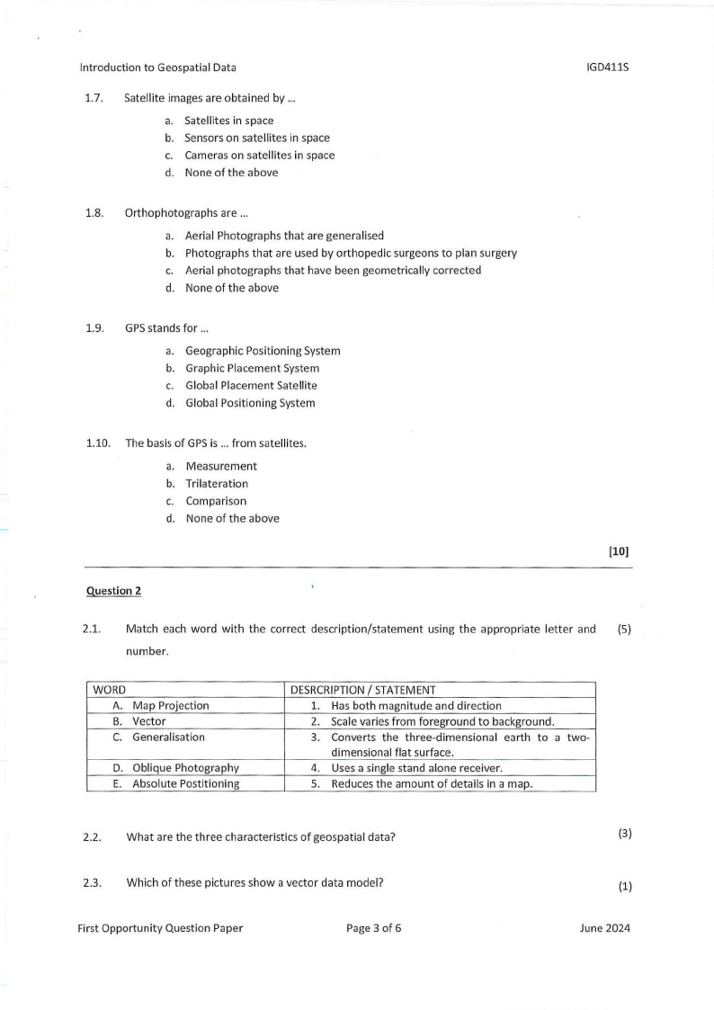
2.3. Which of these pictures show a vector data model?
First Opportunity Question Paper
Page3 of 6
(3)
(1)
June 2024
|
|
4 Page 4 |
▲back to top |
Introduction to Geospatial Data
Picture A
•
Picture B
IGD411S
2.4. Mention:
(2)
i. the set of lines which run from North to South but show location in the East-West
direction and
ii. the set of lines that run from East to West but show location in the North-South direction.
2.5. Complete the sentence: The ... is the most convenient mathematical model for measuring (1)
locations.
2.6. Calculate the straight-line distance from 56° 10' 20" E to 47° 38' 29" E at 78° 51' 39" S.
(4)
(16)
Question 3
3.1. A Land parcel located in the Usakos area has the following co-ordinates:
(5)
Point
Y
X
A
-10 697.20
+20 719.20
B
-13 742.20
+21546.70
C
-14 050.60
+22 829.50
D
-11581.50
+23 233.60
i. Calculate the distance from B to D
3.2. Convert the following geographical coordinates into degrees, minutes and seconds.
(6)
a. 22.639°5
b. 17.963°E
3.3. Calculate the scale of map A if the length of a river is 3 cm on the map, while the same river is (4)
40 mm on map B with scale 1:150 000.
(15)
First Opportunity Question Paper
Page4 of 6
June 2024
|
|
5 Page 5 |
▲back to top |
Introduction to Geospatial Data
Question 4
IGD411S
4.1 A scale is defined as the ratio or relationship between the size of the features on the map and (6)
their corresponding features on the ground. List the six factors that effects the choice of
scale.
4.2 What do you call the bolded contours on a map?
(1)
4.3 Given a slope of 85.67% convert your slope to degrees.
(3)
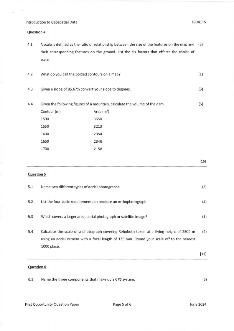
4.4 Given the following figures of a mountain, calculate the volume of the dam.
Contour (m)
Area (m2)
1500
3650
1550
3213
1600
2954
1650
2346
1700
2158
Question 5
5.1 Name two different types of aerial photographs.
(5)
(15]
(2)
5.2 List the four basic requirements to produce an orthophotograph.
(4)
5.3 Which covers a larger area, aerial photograph or satellite image?
(1)
5.4 Calculate the scale of a photograph covering Rehoboth taken at a flying height of 2500 m (4)
using an aerial camera with a focal length of 135 mm. Round your scale off to the nearest
1000 place.
(11]
Question 6
6.1 Name the three components that make up a GPSsystem.
(3)
First Opportunity Question Paper
Page 5 of 6
June 2024
|
|
6 Page 6 |
▲back to top |
Introduction to Geospatial Data
6.2 What is the minimum number of satellites required to compute a reliable GPSposition?
IGD411S
(1)
6.3 What does DOP stand for?
(1)
6.4 Below are two DOP values. indicate the Stronger DOP value.
(1)
DOPvalue of 2
DOP value of 9
6.5 List seven GPS/GNSSerror sources, excluding human error.
{7)
(13]
: , "·' . II
i° • , ,I .
', J~
I
I •''
111, 1
First Opportunity Question Paper
Page 6 of6
June 2024