 |
CAS610S - CADASTRAL SURVEYING 2 - 2ND OPP - JULY 2024 |
 |
1 Page 1 |
▲back to top |

nAmI BIAunIVER s ITY
OFSCIEnCEAno TECHnOLOGY
FACULTY OF ENGINEERING AND THE BUILT ENVIRONMENT
DEPARTMENTOF LAND AND SPATIALSCIENCES
QUALIFICATIONS:BACHELOROF GEOMATICS,DIPLOMA IN GEOMATICS
QUALIFICATIONSCODES:06DGEO0, 7BGEO QUALIFICATIONSLEVEL:6-06DGEO, 7 - 07BGEO
COURSECODE: CAS610S
COURSENAME: CADASTRALSURVEYING2
SESSION: JULY2024
DURATION: 3 HOURS
PAPER: THEORY
MARKS: 100
SECONDOPPORTUNITY/SUPPLEMENTARYEXAMINATION QUESTIONPAPER
EXAMINER:
MrT. Makaza
MODERATOR:
Mr S. Sinvula
INSTRUCTIONS
1. Answer ALL questions.
2. Write clearly and neatly.
3. Number the answers clearly.
PERMISSIBLEMATERIALS
Calculators may be used as well as other drawing equipment.
THIS QUESTIONPAPERCONSISTSOF 5 PAGES(Including this Front Page).
 |
2 Page 2 |
▲back to top |

Cadastral Surveying 2
Question 1
CAS610S
(a) Chapter 3 of the Land Survey Act 33 of 1993 deals with Original Surveys and Resurveys. Explain two
scenarios of original surveys in terms of section 8 and 9 of the Act.
(2)
(b) Under what circumstances shall it be necessaryto resurvey a township?
(2)
(c) Describe the procedure to be followed when any person who, for the purpose of carrying out any
work which such person may lawfully perform, wishes any beacon or mark erected in connection
with the survey of land to be removed or disturbed. {Section 33of the Act).
(2)
(d) Explain accurately determined.
{2)
(e) Define original diagram.
(2)
(10)
Question 2
State whether TRUEor FALSE
(a) The owner of a property damaged by the placing of a reference mark shall be entitled to
compensation for such damage.
(1)
(b)
Once a general plan is approved by the Surveyor General and filed and registered in the deeds
registry no alterations or amendments can be made on it.
(1)
(c)
The Surveyor General is responsible for maintenance of reference marks that fall within a local
authority area.
(1)
(d)
An owner of the servient tenement can claim compensation from the state for depreciation of land
as a result of a beacon or trigonometrical beacon erected on his/her land.
(1)
(e)
The Act does not apply with respect to land vesting in the State.
{1)
(f)
Land surveyors can enter private land any time they wish.
(1)
(g) On a general plan, it shall not be necessary to record data on both sides of a common boundary.
(1)
(h) On a general plan, when the sides of two or more adjoining erven in a block are parallel, it shall
only be necessary to record the directions of the first and last of those parallel sides.
Second Opportunity Examination
Page 2 of 5
(1)
JULY2024
 |
3 Page 3 |
▲back to top |

CadastralSurveying2
CAS6105
(i)
On a general plan it is not necessary to show coordinates for all placed beacons unless they are
block corners.
(1)
{j)
When a survey for replacement of beacons involves only their replacement into coordinate
positions previously established on the trigonometrical system, the land surveyor does not need to
lodge the usual complete set of survey records.
(1)
(k) If the owner desires to effect a separate registration of the remaining extent of the piece of land it
shall not be compulsory to so submit a diagram of such remaining extent.
(1)
(I)
When a fence post forms part of a properly erected fence and occupies a corner point of land being
surveyed, it may be adopted as a beacon.
(1)
[12)
Question 3
(a) In terms of Act 33 of 1993, the Survey Regulation Board may make regulations in relation to certain
matters. Name ANY 8 of them.
(8)
(b) State the composition of the Survey Regulations Board.
(4)
(c) State who is responsible for maintaining in proper order any beacon or mark defining a corner point
of a piece of land.
(2)
(d) When a river constitutes a boundary of any piece of land such piece of land shall be deemed to
extend to the middle of the river except in certain cases. Name such exceptions.
(5)
(e) Explain a situation that may necessitate a resurvey of a township.
(2)
(f)
Before a local authority applies to the Minister for a resurvey of a township or a portion of a
township falling within its area of jurisdiction, the local authority shall, in consultation with the
Surveyor-General, cause a notice of the intended application for resurvey to. State 2 methods that
are used to make such a notice .
(2)
(g) What are the 3 options of beaconing a servitude of uniform/defined width?
(3)
[26)
SecondOpportunity Examination
Page3 of S
JULY2024
 |
4 Page 4 |
▲back to top |

Cadastral Surveying 2
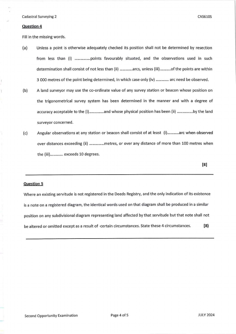
Question 4
CAS610S
Fill in the missing words.
(a} Unless a point is otherwise adequately checked its position shall not be determined by resection
from less than (i) ...............p. oints favourably situated, and the observations used in such
determination shall consist of not less than (ii) .............arcs, unless (iii) ...........of the points are within
3 000 metres of the point being determined, in which case only (iv) .............arc need be observed.
(b) A land surveyor may use the co-ordinate value of any survey station or beacon whose position on
the trigonometrical survey system has been determined in the manner and with a degree of
accuracy acceptable to the (i)..............a. nd whose physical position has been (ii) ...............b. y the land
surveyor concerned.
(c) Angular observations at any station or beacon shall consist of at least (i)...........a. rc when observed
over distances exceeding (ii} ..............m. etres, or over any distance of more than 100 metres when
the (iii) .............exceeds 10 degrees.
(8)
Question 5
Where an existing servitude is not registered in the Deeds Registry, and the only indication of its existence
is a note on a registered diagram, the identical words used on that diagram shall be produced in a similar
position on any subdivisional diagram representing land affected by that servitude but that note shall not
be altered or omitted except as a result of -certain circumstances. State these 4 circumstances.
(8)
Second Opportunity Examination
Page 4 of 5
JULY2024
 |
5 Page 5 |
▲back to top |

Cadastral Surveying 2
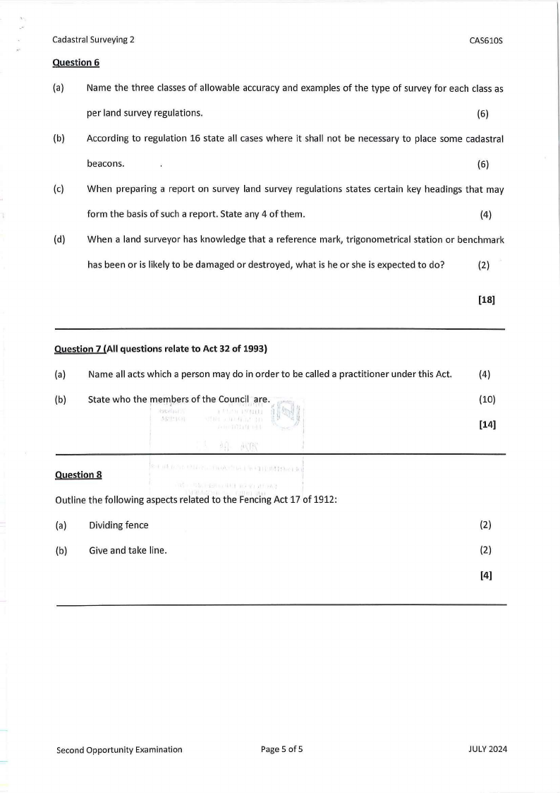
Question 6
CAS610S
(a) Name the three classesof allowable accuracy and examples of the type of survey for each class as
per land survey regulations.
(6)
(b) According to regulation 16 state all cases where it shall not be necessary to place some cadastral
beacons.
(6)
(c) When preparing a report on survey land survey regulations states certain key headings that may
form the basis of such a report. State any 4 of them.
(4)
(d) When a land surveyor has knowledge that a reference mark, trigonometrical station or benchmark
has been or is likely to be damaged or destroyed, what is he or she is expected to do?
(2)
[18)
Question 7 {All questions relate to Act 32 of 1993)
(a) Name all acts which a person may do in order to be called a practitioner under this Act.
(4)
(b)
State who the mem'b. ers of the Council are.
(10)
[14)
Question 8
Outline the following aspects related to the Fencing Act 17 of 1912:
(a) Dividing fence
(2)
(b) Give and take line.
(2)
[4)
Second Opportunity Examination
Page S of S
JULY2024


