 |
IGD411S - INTRODUCTION TO GEOSPATIAL DATA - 1ST OPP - JUNE 2022 |
 |
1 Page 1 |
▲back to top |

n Am I BIA u n IVE Rs ITY
OF SCIEnCE TECHnOLOGY
FACULTYOF ENGINEERINGAND SPATIALSCIENCES
DEPARTMENTOF ARCHITECUREAND SPATIALSCIENCES
QUALIFICATION: BACHELOR OF NATURAL RESOURCEMANAGEMENT (NATURE CONSERVATION),
BACHELOR OF GEOINFORMATION TECHNOLOGY, BACHELOR OF LAND ADMINISTRATION, BACHELOR OF
PROPERTY STUDIES HONOURS, BACHELOR OF REGIONAL AND RURAL DEVELOPMENT, BACHELOR OF
TOWN AND REGIONAL PLANNING, DIPLOMA IN PROPERTYSTUDIES
QUALIFICATION CODE: 07BNRS, 07BGEI,
07BLAM, 08BPRS, 07BRAR, 07BTAR, LEVEL: 4
06DPRS
COURSE:
INTRODUCTION TO
GEOSPATIAL DATA
COURSE CODE: IGD411S
SESSION: JUNE 2022
PAPER:
THEORY
DURATION: 2 HOURS
MARKS:
80
EXAMINER:
MODERATOR:
FIRSTOPPORTUNITYEXAMINATION QUESTION PAPER
MS. D. HUSSELMANN
MR E. NAOSEB
INSTRUCTIONS
1. Answer ALL the questions.
2. Write clearly and neatly.
3. Number the answers clearly.
4. Answers to calculations must be rounded off to three decimal places,
excluding answers to co-ordinate conversions
PERMISSIBLE MATERIALS
1. Examination paper.
2. Examination script.
3. Calculators and other drawing equipment.
THIS QUESTION PAPER CONSISTS OF 6 PAGES (Including this front page)
 |
2 Page 2 |
▲back to top |

Introduction to Geospatial Data
Question 1
IGD411S
Select only the letter considered to be the correct answer.
(10)
1.1. The term geospatial data is a composite of two words. "Geo" refers to the earth, and the second
part "spatial data" is data that contains ...
a. Data values about satellites in space
b. Data about special state projects
c. Coordinate values
d. None of the above
1.2. Lines of longitude give direction ...
a. East-West
b. North-South
c. South only
d. None of the above
1.3. A raster model is formed by ...
a. Points and lines
b. Rows and columns
c. Lines and polygons
d. None of the above
1.4. Which of these form part of the marginal information of a map?
a. Meridians
b. Contour lines
c. North Arrow
d. None of the above
1.5. Spot heights ...
a. Are always the same height above sea level
b. Are always at the centre of contour lines
c. Are just random points on a map with no meaning
d. None of the above
First Opportunity Question Paper
Page 2 of 6
June 2022
 |
3 Page 3 |
▲back to top |

Introduction to Geospatial Data
1.6. We want to map Namibia using the concept of map series. This allows for ...
a. Having a larger scale, allowing more detail to be shown
b. Having a larger scale, allowing less detail to be shown
c. Having a smaller scale, allowing more detail to be shown
d. None of the above
IGD411S
1.7. Aerial photographs are ...
a. Photographs that are generalised
b. Photographs that are thrown in the air
c. Photographs that are captured from the air using a camera
d. None of the above
1.8. Stereo photographs result when two photographs are taken from slightly different angles making
them appear ...............when viewed together (choose the correct word below).
a. Clear
b. Three-dimensional
c. Accurate
d. None of the above.
1.9. Which of these are the same as a satellite?
a. Receiver
b. Space vehicle
c. Drone
d. None of the above
1.10. Two different types of GPSpositioning modes are:
a. Absolute positioning and stand-alone positioning
b. Differential gps and relative gps
c. Absolute positioning and autonomous positioning
d. None of the above
(10)
Question 2
2.1. Geospatial data has three main characteristics, what are they?
First Opportunity Question Paper
Page 3 of 6
(3)
June 2022
 |
4 Page 4 |
▲back to top |

Introduction to Geospatial Data
2.2. Name the coordinate systems that make use of the following coordinates:
a. Latitude and longitude coordinates:
IGD411S
(2)
b. X and Y coordinates:
2.3. Calculate the straight-line distance from 10° 56' 20" S to 38° 47' 29" S.
(4)
2.4. Name (a) the actual shape of the earth and (b) the most convenient mathematical model used for
measuring locations on earth.
(2)
[11)
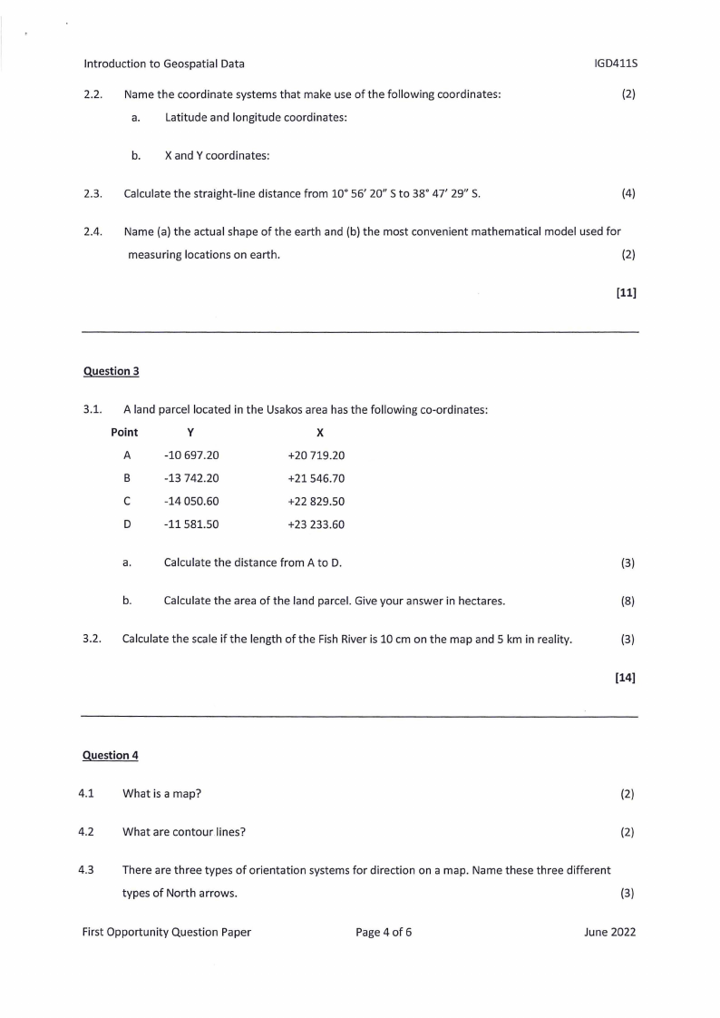
Question 3
3.1. A land parcel located in the Usakos area has the following co-ordinates:
Point
y
X
A
-10 697.20
+20 719.20
B
-13 742.20
+21546.70
C
-14 050.60
+22 829.50
D
-11581.50
+23 233.60
a.
Calculate the distance from A to D.
(3)
b.
Calculate the area of the land parcel. Give your answer in hectares.
(8)
3.2. Calculate the scale if the length of the Fish River is 10 cm on the map and 5 km in reality.
(3)
[14)
Question 4
4.1
What is a map?
(2)
4.2
What are contour lines?
(2)
4.3
There are three types of orientation systems for direction on a map. Name these three different
types of North arrows.
(3)
First Opportunity Question Paper
Page 4 of 6
June 2022
 |
5 Page 5 |
▲back to top |

Introduction to Geospatial Data
IGD411S
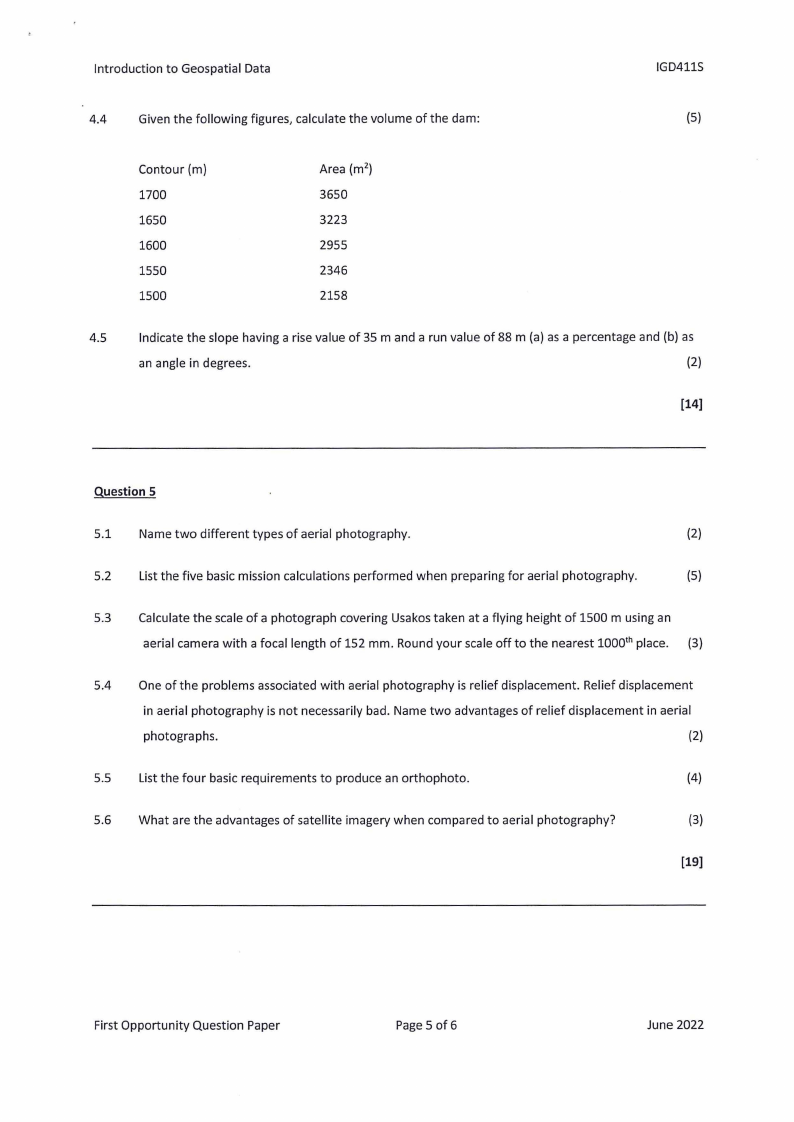
4.4
Given the following figures, calculate the volume of the dam:
(5)
Contour (m)
1700
1650
1600
1550
1500
Area (m2)
3650
3223
2955
2346
2158
4.5
Indicate the slope having a rise value of 35 m and a run value of 88 m (a) as a percentage and (b) as
an angle in degrees.
(2)
[14]
Question 5
5.1 Name two different types of aerial photography.
(2)
5.2 List the five basic mission calculations performed when preparing for aerial photography.
(5)
5.3 Calculate the scale of a photograph covering Usakos taken at a flying height of 1500 musing an
aerial camera with a focal length of 152 mm. Round your scale off to the nearest 1000th place. (3)
5.4 One of the problems associated with aerial photography is relief displacement. Relief displacement
in aerial photography is not necessarily bad. Name two advantages of relief displacement in aerial
photographs.
(2)
5.5 List the four basic requirements to produce an orthophoto.
(4)
5.6 What are the advantages of satellite imagery when compared to aerial photography?
(3)
[19]
First Opportunity Question Paper
Page 5 of 6
June 2022
 |
6 Page 6 |
▲back to top |

Introduction to Geospatial Data
Question 6
IGD411S
6.1 Name three GPScomponents.
(3)
6.2 List any four error sources of GPS/GNSSerror sources, excluding human error.
(4)
6.3 What is meant by satellite geometry?
(1)
6.4 Draw two pictures; one showing good satellite geometry and one showing bad satellite geometry.
(4)
[12]
First Opportunity Question Paper
Page 6 of 6
June 2022


