


 |
GES512S - GEOGRAPHIC INFORMATION SYSTEMS 1 - 2ND OPP - JAN 2020 |
|
|
1 Page 1 |
▲back to top |
|
Bi ia
NAMIBIA UNIVERSITY
OF SCIENCE AND TECHNOLOGY
FACULTY OF NATURAL RESOURCES AND SPATIAL SCIENCES
DEPARTMENT OF GEO-SPATIAL SCIENCES AND TECHNOLOGY
QUALIFICATION:
DIPLOMA IN GEOMATICS, DIPLOMA IN LAND ADMINISTRATION, DIPLOMA IN PROPERTY
STUDIES, BACHELOR OF GEOMATICS, BACHELOR OF GEOINFORMATION TECHNOLOGY,
BACHELOR OF TOWN AND REGIONAL PLANNING, BACHELOR OF REGIONAL & RURAL
DEVELOPMENT, BACHELOR OF LAND ADMINISTRATION, BACHELOR OF PROPERTY STUDIES
QUALIFICATION CODE:
O6DGEM, O6DLAD, O6DPRS, 07BGEM, | LEVEL: 5
O7GITB, O7BTAR, 07BRAR, 07BLAD
COURSE CODE: GES5125
COURSE NAME: GEOGRAPHIC INFORMATION
SYSTEMS 1
SESSION:
JANUARY 2020
PAPER:
THEORY
DURATION:
3 HOURS
MARKS:
100
2"¢ OPPORTUNITY/SUPPLEMENTARY EXAMINATION QUESTION PAPER
EXAMINER
Mr. Erich Naoseb
moperator: | Mr. Miguel Vallejo
INSTRUCTIONS
1. Answer ALL the questions.
Write clearly and neatly.
Number the answers clearly.
PERMISSIBLE MATERIALS
PERMISSIBLE MATERIALS
1. Examination paper.
Examination script.
3. Calculator, ruler, pencil, eraser.
THIS QUESTION PAPER CONSISTS OF 6 PAGES (Including this front page)
|
|
2 Page 2 |
▲back to top |
Geographic Information Systems 1
GES512S
Question 1 Complete the missing words in the below statements
1.1. The secant case means that a cylindrical projection has
line(s) of tangency.
(1)
1.2. Each UTM zone covers
degrees in longitude
(1)
1.3. The central meridian of a UTM zone has a scale factor of
(1)
1.4. False Easting applies to
coordinate.
(1)
1.5. Global Positioning Systems (GPS) readings are based on the
datum.
(1)
1.6. Vector data are better suited for representing
better suited for representing
features.
features and raster data are
(2)
1.7. The
surface.
is the reference system for locating spatial features on the Earth’s
(1)
18. A
plane.
transforms the geographic coordinates on an ellipsoid into locations on a
(1)
19. A
refers to the line of tangency between the projection surface and the
(1)
reference globe.
[10]
Question 2
2.1. Provide a brief explanation of the terms below.
a) False easting:
b) False northing:
c) Latitude:
d) Longitude:
e) Projected coordinate system:
24 Opportunity/Supplementary Question Paper
Page 2 of 6
(1)
e)
(1)
January 2020
|
|
3 Page 3 |
▲back to top |
Geographic Information Systems 1
f) Projection:
g) Union:
h) Equivalent projection:
i) Ellipsoid:
j) Map:
2.2. How does a GIS software (e.g., ArcGIS for Desktop) differ from Google Maps?
GES512S
(1)
(1)
(1)
(1)
(1)
(4)
2.3. A Geographical Information System (GIS) can work with spatial and non-spatial data. Name
(3)
three ways in which data input in a geographical Information system can be broken down.
[17]
Question 3
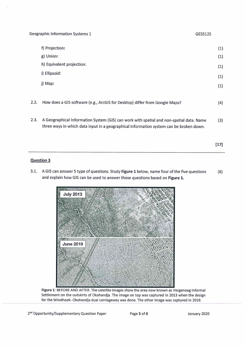
3.1. AGIS can answer 5 type of questions. Study Figure 1 below, name four of the five questions
(8)
and explain how GIS can be used to answer those questions based on Figure 1.
MES
ag
areCF.
Figure 1: BEFORE AND AFTER. The satell
es show the area now known as Vergenoeg Informal
Settlement on the outskirts of Okahandja. The image on top was captured in 2013 when the design
for the Windhoek- Okahandja dual carriageway was done. The other image was captured in 2019.
2"4 Opportunity/Supplementary Question Paper
Page 3 of 6
January 2020
|
|
4 Page 4 |
▲back to top |
Geographic Information Systems 1
GES512S
3.2. What are the three important characteristics that map projections should attempt to keep?
(3)
3.3. Explain the difference between thematic rasters and image rasters.
(4)
3.4. Explain what vector overlay is and list three common vector overlay methods.
(4)
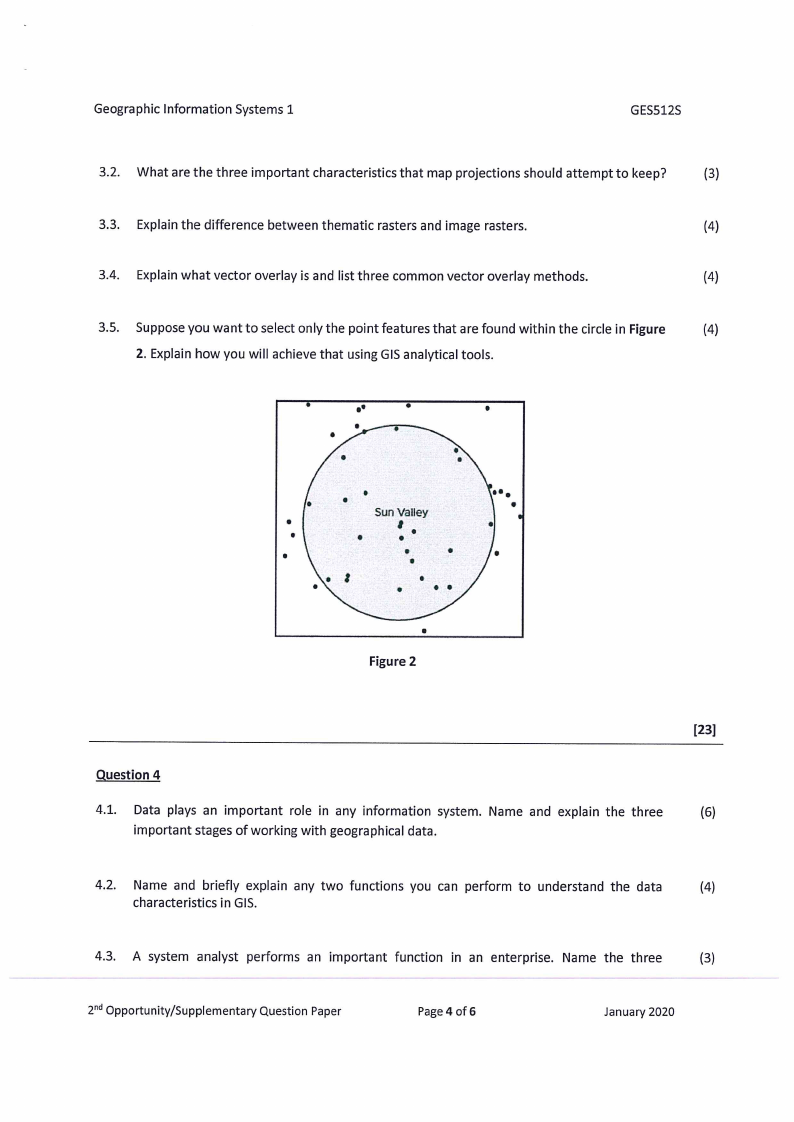
3.5. Suppose you want to select only the point features that are found within the circle in Figure
(4)
2. Explain how you will achieve that using GIS analytical tools.
.
°°
e
°
s
e
9
e
Figure 2
[23]
Question 4
4.1. Data plays an important role in any information system. Name and explain the three
(6)
important stages of working with geographical data.
4.2. Name and briefly explain any two functions you can perform to understand the data
(4)
characteristics in GIS.
4.3. A system analyst performs an important function in an enterprise. Name the three
(3)
2°¢ Opportunity/Supplementary Question Paper
Page 4 of 6
January 2020
|
|
5 Page 5 |
▲back to top |
Geographic Information Systems 1
GES512S
modelling techniques that a system analyst can use to organize information in an enterprise.
4.4. Explain the raster data model as a means of representing GIS data.
(3)
4.5. Describe the three types of map projections by the distortion properties.
(6)
4.6. Briefly explain what a Geographic coordinate system is.
(3)
[25]
Question 5
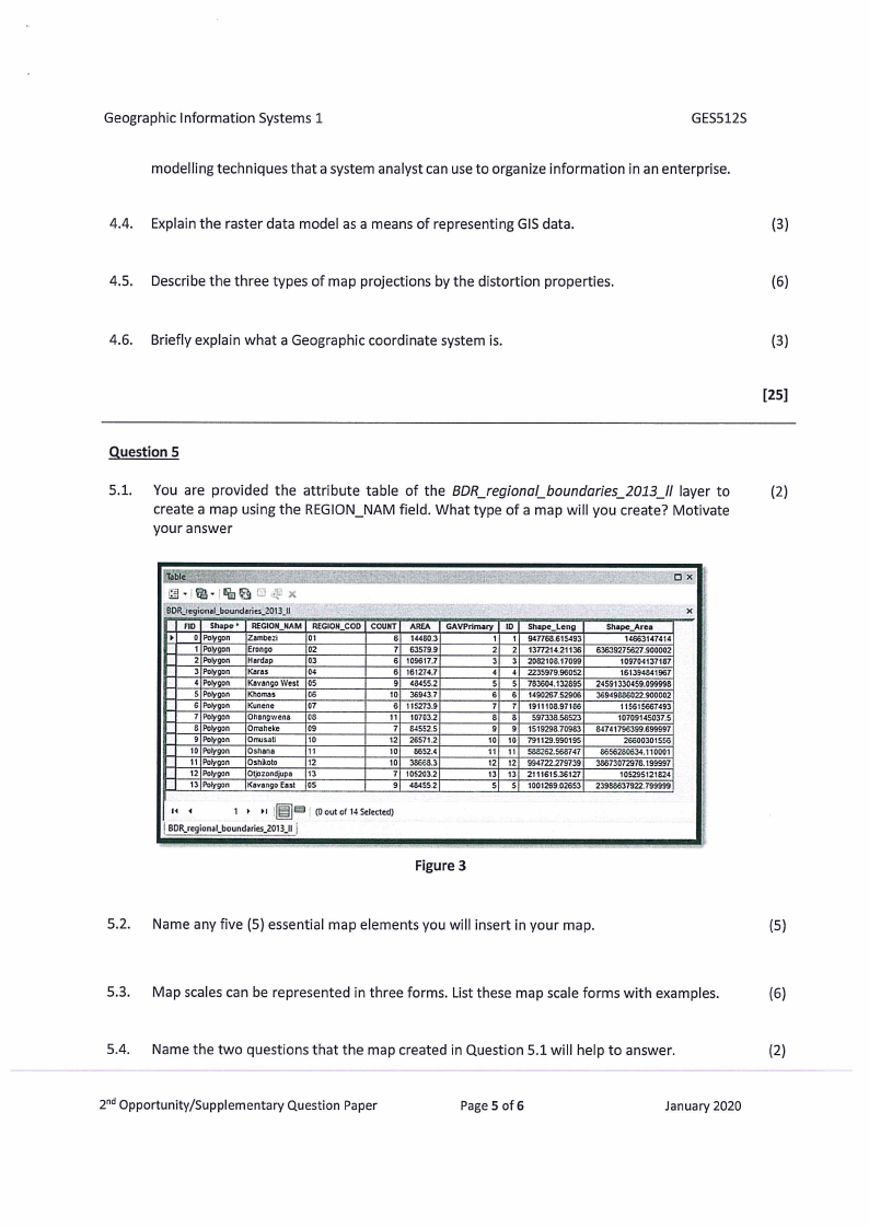
5.1. You are provided the attribute table of the BDR_regional_boundaries_2013_II layer to
(2)
create a map using the REGION_NAM field. What type of a map will you create? Motivate
your answer
my
x
BDR_regional_boundaries_2013 I}
FID | Shape* | REGION_NAM/} REGION_COD | COUNT} AREA
GAVPrimary | 1D | Shape_Leng
>
0} Polygon
Zambezi
01
6} 14480.3
1
4| 947768.615493
1|Poltygon
Erongo
02
7| 63579.9
2 2) 1377214.21136
2} Polygon
Hardap
03
6} 109617.7
3 3} 2082108.17099
3}Polygon Karas
04
6] 161274.7
4 4| 2235979.96052
4} Polygon
Kavango West {05
9] 48455.2
5} 5] 783604.132895|
5} Polygon Khomas
06
10} 36943.7
6| 6] 1490267.52906|
6|Polygon
Kunene
07
6} 115273.9
7 7} 1911108.97186
7 {Polygon
Ohangwens
08
41} 10703.2
8 8 §97338.58523
8|Polygon
Omaheke
09
7} 845525
9 9| 1519293.70983
9|Polygon
Omusati
10
12] 26571.2
10} 10] 791129.990195
10 | Polygon
Oshana
"1
10 8652.4
41] 11] 588262.568747
11|Polygon Oshikoto
12.
10| 38668.3
12| 2] 994722.279739
12| Polygon Otjozondjupa
13
7{ 105203.2
13} 43] 2111615.36127
13] Polygon
Kavango East [05
9} 484552
5} S| 1001269.02653|
M4
1 > 01 [E3]™ | @out of 14 Selected)
| BOR_regional_boundaries_2013.1 |
ax
:
x
Shape_Area
H
14663147414
i
63639275627.900002
;
109704137187
|
161394841967
5
24591330459.099998
Ff
36949886022.900002
:
115615667493
:
10709145037.5
i
84741796399.699997
'
26600301556
i
$656280634.110001
!
38673072976.199997
ie
105295121824
j
23988537922.799999
f
i
i
;
Figure 3
5.2. Name any five (5) essential map elements you will insert in your map.
(5)
5.3. | Map scales can be represented in three forms. List these map scale forms with examples.
(6)
5.4. | Name the two questions that the map created in Question 5.1 will help to answer.
(2)
24 Opportunity/Supplementary Question Paper
Page 5 of 6
January 2020
|
|
6 Page 6 |
▲back to top |
Geographic Information Systems 1
5.5. Describe the three concepts of attributes using the information in Figure 3.
5.6. Indicate what each of the below terms are used to represent.
a) Contours
b) Isotherms
c) Ilsobaths
d) Isochrones
GES512S
(6)
(4)
[25]
2°! Opportunity/Supplementary Question Paper
Page 6 of 6
January 2020