


 |
RES511S - REMOTE SENSING 1 - 1ST OPP - JUNE 2025 |
|
|
1 Page 1 |
▲back to top |
nAmlBIA un1VERSITY
OF SCIEnCE Ano TECHnOLOGY
FACULTY OF ENGINEERING AND THE BUILT ENVIRONMENT
DEPARTMENTOF LANDAND SPATIALSCIENCES
QUALIFICATIONS:
DIPLOMA IN GEOMATICS, BACHELOR OF GEOMATICS, BACHELOR OF GEOINFORMATION
TECHNOLOGY
QUALIFICATIONCODES:
LEVEL:
06DGEO, 07BGEO, 07BGEI
Level 6 - 06DGEO
Level 7 - 07BGEO, 07BGEI
COURSECODE: RES511S
SESSION:JUNE 2025
COURSENAME: REMOTE SENSING 1
PAPER:THEORY
DURATION: 3 HOURS
MARKS: 100
FIRSTOPPORTUNITYEXAMINATION QUESTIONPAPER
EXAMINER: Ms Roxanne Murangi
MODERATOR: Ms Celeste Espach
INSTRUCTIONS
1. Write your student number and programme code (e.g.07BGEI ) on the answer sheet.
2. Answer ALL the questions.
3. Read each question carefully before attempting to answer.
4. Write clearly and neatly.
PERMISSIBLEMATERIALS
1. Pen
2. Pencil
3. Eraser
4. Ruler
5. Non-programming calculator
This question paper consists of nine (9) pages, including this cover page.
|
|
2 Page 2 |
▲back to top |
RelllotP SPn<.ingl
Question 1
RESS11S
Answer the multiple-choice questions listed below. Pleaseselect the ONE most relevant to
the following questions. Indicate the correct answer on the answer sheet.
1.1. Which of the following best describes electromagnetic energy?
(1)
A. It consists only of electrical fields
B. It is a form of energy that travels in waves and as particles
C. It requires a medium for propagation, like sound waves
D. It does not interact with the Earth's atmosphere
1.2. Which of the following statements about electromagnetic waves is INCORRECT?
(1)
A. All electromagnetic waves travel at identical speeds in a vacuum.
B. As wavelength increases, the frequency proportionally decreases.
C. Shorter wavelengths penetrate the atmosphere more effectively.
D. Thermal infrared sensors detect emitted rather than reflected energy.
1.3. What type of remote sensing system actively generates energy to illuminate a target? (1)
A. Active sensor
B. Thermal sensor
C. Passivesensor
D. Optical sensor
1.4. A researcher needs to monitor daily changes in sea surface temperature. Which
satellite sensor would be most appropriate?
(1)
A. Radar
B. Panchromatic
C. Thermal infrared
D. LiDAR
First Opportunity Question Paper
Page 2 of 8
June 2025
|
|
3 Page 3 |
▲back to top |
Remotr Sensing l
FU:S51'l S
1.5. A radio wave has a frequency of 67 Hz. Calculate its wavelength in meters and choose
the correct answer from the following options:
(1)
A. 0.044 x 10¹⁰ m
B. 1.04 x 10⁸ m
(. 0.44 X 10⁸ m
D. 0.044 x 10⁸ m
1.6. Which factor reduces the radiometric resolution of remotely sensed imagery?
(1)
A. Increased bit depth
B. Larger sensor size
C. Atmospheric scattering
D. Higher altitude
1.7. What is spectral analysis in remote sensing image interpretation?
(1)
A. The process of analysing the spatial relationships between features on the Earth's
surface.
B. The process of analysing the colour and intensity of light reflected from the Earth's
surface.
C. The process of analysing the physical properties of the Earth's surface.
D. The process of analysing changes in features on the Earth's surface over time.
1.8. An urban planner must identify individual tree species in a city park. What spatial
resolution would be most appropriate?
(1)
A. 0.5 m
B. 10m
C. 15 m
D. 30 m
First Opportunity Question Paper
P;:ige3 of 8
June 2025
|
|
4 Page 4 |
▲back to top |
Hernole SP.n':>inlg
HES.511S
1.9. A flood has occurred in a region with continuous cloud cover. Which type of sensor
would provide the best data for mapping the flood extent?
(1)
A. Optical (Visible & Infrared)
B. Thermal Infrared
C. Ultraviolet
D. Microwave (Radar)
1.10. Which of the following satellite sensors provides the highest spatial resolution?
(1)
A. Sentinel-2 MSI
B. Landsat 8 OLI
C. WorldView-3
D. MODIS
[10]
Question 2
2.1. A conservation agency wants to monitor deforestation in a remote rainforest with
limited access.They need to track changes in vegetation over time and assessareas
with illegal logging.
2.1.1. Explain how remote sensing can be used to achieve this goal.
(4)
2.1.2. Which type of satellite images or remote sensing technology would be best
for monitoring deforestation, and why?
(4)
2.1.3. Justify why remote sensing is more effective than traditional ground surveys
in this scenario.
(3)
2.2. Describe how the Electromagnetic Spectrum relates to remote sensing.
(3.5)
First Opportunity Ques1ion Pt1per
P<1ge4 of 8
June 2025
|
|
5 Page 5 |
▲back to top |
Remote Senc;i11gI
rffSSl lS
2.3. Describe how atmospheric windows affect remote sensing data acquisition and
provide two (2) examples of atmospheric windows commonly used in satellite remote
sensing.
(5)
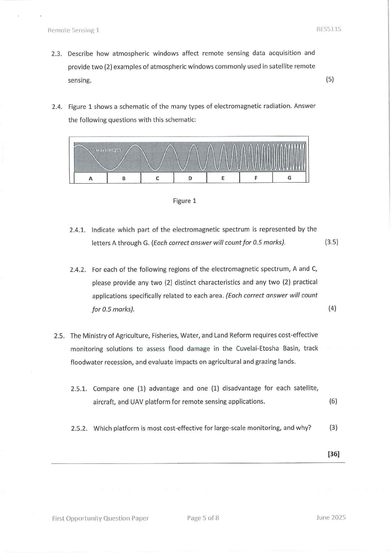
2.4. Figure 1 shows a schematic of the many types of electromagnetic radiation. Answer
the following questions with this schematic:
Figure 1
2.4.1. Indicate which part of the electromagnetic spectrum is represented by the
letters A through G. (Each correct answer will count for 0.5 marks).
(3.5)
2.4.2. For each of the following regions of the electromagnetic spectrum, A and C,
please provide any two (2) distinct characteristics and any two (2) practical
applications specifically related to each area. (Each correct answer will count
for 0.5 marks).
(4)
2.5. The Ministry of Agriculture, Fisheries, Water, and Land Reform requires cost-effective
monitoring solutions to assess flood damage in the Cuvelai-Etosha Basin, track
floodwater recession, and evaluate impacts on agricultural and grazing lands.
2.5.1. Compare one (1) advantage and one (1) disadvantage for each satellite,
aircraft, and UAV platform for remote sensing applications.
(6)
2.5.2. Which platform is most cost-effective for large-scale monitoring, and why?
(3)
[36)
First Opportunity Question Paper
Page 5 of 8
June 2025
|
|
6 Page 6 |
▲back to top |
Remote Scnsine l
Question 3
Rl:S5'\\"IS
3.1. Environmental scientists monitor atmospheric conditions near Namibia's coastal
region where the Namib Desert meets the Atlantic Ocean. They observe that the sky
appears intensely red-orange during sunrise over the desert, while a whitish haze
forms above fishing communities at midday when boats are most active. During the
dry season, large dust storms from the desert create thick, white-grey clouds that
block sunlight completely.
Analyse and describe the different types of scattering occurring in this scenario.
(6)
3.2. Compare active and passive sensors in remote sensing based on their energy source,
usage conditions, and applications. Present your comparison in a table format.
(6)
3.3. After a wildfire in Etosha National Park, you must select appropriate satellite imagery
to monitor the impact on wildlife habitat.
3.3.1. What image detail level (spatial resolution) would you need to see the burned
areas in Etosha?
(2)
3.3.2. Which spectral bands would help you see damaged vegetation in the park?
(2)
3.3.3. How often (temporal resolution) should you take images during the rainy
season to track recovery?
(2)
3.3.4. Why does image sensitivity (radiometric resolution) matter when looking at
bright landscapes like Etosha Pan?
(2)
[20]
First Opportunity Question Poper
Page 6 of8
June 202'.J
|
|
7 Page 7 |
▲back to top |
Kemote Sensing 1
Question 4
HESSllS
4.1. You're part of a wildlife conservation team conducting aerial surveys in Etosha
National Park, Namibia. Your aircraft is equipped with a specialised camera that has a
175 mm focal length. During your monitoring flight, you capture photographs from an
altitude of 2450 m above ground level.
Calculate the scale of these photographs to help determine the actual size of ground
features you're observing. (Roundyouranswer to two decimalplacesfor metres.)
(5)
4.2. The Ministry of Environment and Tourism in Namibia has commissioned an aerial
survey of Etosha National Park to monitor elephant populations and migration
patterns. As a GIS specialist with the Namibia Wildlife Conservation Department,
you've been asked to create detailed maps at a scale of 1:5000 to help rangers track
and protect.
You have accessto aerial photographs taken in 2023 by a camera with a focal length
of 152 mm at a scale of 1: 18000. Before creating your maps, you need to determine
the altitude at which the survey aircraft flew to capture these images, as this
information will be required for your technical report and for planning future survey
missions.
Task
Calculate the flying height of the aircraft when these photos were taken, expressing
your answer in metres and feet. Show all your calculations and round your final
answers to whole numbers.
(5)
4.3. You are conducting an aerial survey over the Namib Desert using a MicaSense camera.
You need an image with a ground resolution of 10 cm/pixel. Given that the camera
has a CFOV of 50° and an image resolution (w*h) of 1920 x 1080, calculate the
required flight height, expressing your answer in metres and feet. Show all your
calculations and round your final answers to whole numbers.
(10)
First Opportunity Queslion Paper
Page 7 of 8
June 2025
|
|
8 Page 8 |
▲back to top |
Remote Sen~ing 1
RFSSllS
4.4. Determine the number of rows and columns of a band from Landsat 7 ETM with only
the following information: its spatial resolution is 30 m, the swath width is 183 km,
and the rows is 15 % less than the number of columns. Show all your calculations.
(6)
4.5. What is electromagnetic radiation's wavelength (µm) with a frequency of 8000 MHz?
(Round to three (3) decimal places for metres).
(4)
4.6. Electromagnetic radiation has a wavelength of 0.055 mm. What is its frequency in
MHz?
(4)
[34]
rirst Opportunity Question Paper
Page 8 of 8
II
I
June 2025