


 |
GES512S - GEOGRAPHIC INFORMATION SYSTEMS 1 - 1ST OPP - JUNE 2022 |
|
|
1 Page 1 |
▲back to top |
nAm I BIA un1ve RSITY
OF SCIEnCE Ano TECHnOLOGY
FACULTYOF ENGINEERINGAND SPATIALSCIENCES
DEPARTMENT OF ARCHITECTURE AND SPATIAL SCIENCES
QUALIFICATION:
DIPLOMA IN LAND ADMINISTRATION, DIPLOMA IN PROPERTYSTUDIES, BACHELOR OF LAND
ADMINISTRATION, BACHELOR OF PROPERTYSTUDIES, BACHELOROF NATURE RESOURCE
MANAGEMENT
QUALIFICATION CODE:
06DGEM, 06DLAD, 06DPRS, 07BLAD,
08BPRS, 07BNRS
COURSE CODE: GES512S
SESSION: JUNE 2022
LEVEL: 5
COURSE NAME: GEOGRAPHIC INFORMATION
SYSTEMS 1
PAPER: THEORY
DURATION: 3 HOURS
MARKS: 100
EXAMINER
MODERATOR:
FIRST OPPORTUNITY EXAMINATION QUESTION PAPER
MRS. ROXANNE MURANGI
MR. MIGUEL VALLEJO
THIS QUESTION PAPERCONSISTSOF SEVEN(7) PAGES
(INCLUDINGTHIS FRONTPAGE)
INSTRUCTIONS
1. Fill in the exam sheet. Write your name and student number on the answer sheet.
2. Read each question carefully before attempting to answer.
3. Answer ALL the questions.
4. Write clearly and neatly.
5. Materials allowed: Ruler, Pen, Pencil, Eraser (rubber)
|
|
2 Page 2 |
▲back to top |
Geographic Information Systems 1
GES512S
Question 1
State if the following statements are True or False:
1.1 Spatial data means we have data that has graphic values.
(1)
1.2 A (geographic) field is a geographic phenomenon for which, for every point in the study
area a value is not relevant.
(1)
1.3 Man-made phenomena are usually objects.
(1)
1.4 Nominal & categorical data values are referred to as 'qualitative data'.
(1)
1.5 GIS represents X-coordinate in a vertical direction.
(1)
1.6 Data processing is not regarded as one of the functions of an information system.
(1)
1.7 A GISoperation that combines the geometries and attributes of the input layers to create
the output is known as an overlay.
(1)
1.8 Raster graphic in GISrepresents data in a rectangular grid of pixels.
(1)
1.9 False Easting applies to the longitude (X) coordinate.
(1)
1.10 Global Positioning Systems (GPS)readings are based on the WGS84 datum.
(1)
[10]
First Opportunity Exam Question Paper
Page 2 of 7
June 2022
|
|
3 Page 3 |
▲back to top |
Geographic Information Systems 1
Question 2
Define the following terms and provide two examples of each:
2.1 Scale
2.2 Developable surface
2.3 A datum
2.4 Feature dataset
2.5 Geocoding
GES512S
(2)
(2)
(2)
(2)
(2)
[10]
Question 3
3.1 Explain how the vector data model differs from the raster data model in representing spatial
features and provide one suitable example of what each can represent.
(4)
3.2 What is the difference between a coordinate and a coordinate axis?
(3)
3.3 What is the difference between a secant and a tangent projection?
(2)
3.4 What are the three important characteristics of projections?
(3)
3.5 What is the difference between a geoid and a spheroid?
(2)
3.6 Differentiate between spatial and non-spatial attributes and provide two examples for
each.
(4)
3.7 Differentiate between spatial and non-spatial attributes and provide two examples for
each.
(4)
First Opportunity Exam Question Paper
Page 3 of 7
June 2022
|
|
4 Page 4 |
▲back to top |
Geographic Information Systems 1
GES512S
[22)
Question 4
4.1 There are four categories of GIS analytical functions. Briefly discuss them and provide an
example for each
(8)
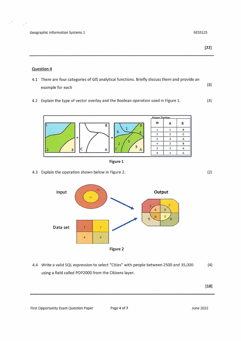
4.2 Explain the type of vector overlay and the Boolean operation used in Figure 1.
(4)
+
=
2
C
Figure 1
4.3 Explain the operation shown below in Figure 2.
Input
10
A
B
8
2
2
C
3
3
A
4
2
8
s
2
A
6
l
C
(2)
Output
Data set
1
/2
4
3
Figure 2
4.4 Write a valid SQL expression to select "Cities" with people between 2500 and 35,000
(4)
using a field called POP2000 from the Citizens layer.
[18)
First Opportunity Exam Question Paper
Page 4 of 7
June 2022
|
|
5 Page 5 |
▲back to top |
Geographic Information Systems 1
Question 5
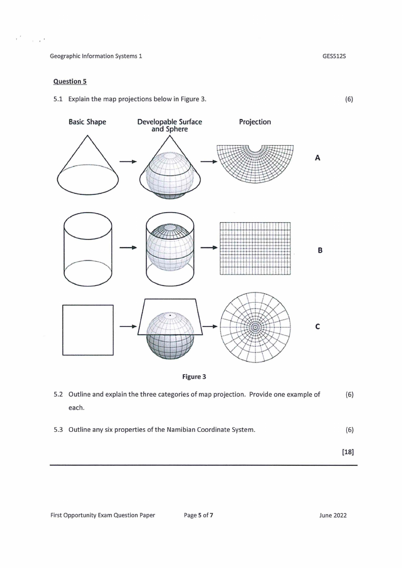
5.1 Explain the map projections below in Figure 3.
BasicShape
DevelopableSurface
and Sphere
Projection
GES512S
(6)
A
I 11 I
lI I11I
111I I I
I II I
I 11 I I
'
+-:; ~rt-m:t ·H· H-l"
··H-1-·
11
B
:,d- I l I
1111
I I 11
I ii i
dI
C
Figure 3
5.2 Outline and explain the three categories of map projection. Provide one example of
(6)
each.
5.3 Outline any six properties of the Namibian Coordinate System.
(6)
[18]
First Opportunity Exam Question Paper
Page 5 of7
June 2022
|
|
6 Page 6 |
▲back to top |
Geographic Information Systems 1
GES512S
Question 6
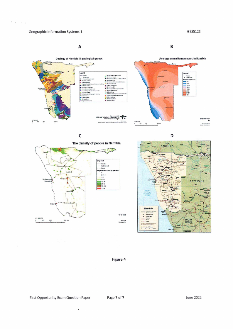
6.1 Identity the type of map A, B, C and Dare below in Figure 4.
(4)
6.2 Under which thematic map category would you classify maps A, B, C, and Din Figure 4?
Motivate your answer.
(8)
6.3 Identify the data type for each map in figure 4.
(4)
6.4 List any five map elements found in any map.
(5)
6.5 What is a small-scale map?
(1)
[22]
First Opportunity Exam Question Paper
Page 6 of 7
June 2022
|
|
7 Page 7 |
▲back to top |
Geographic Information Systems 1
A
Geology of Namibia Ill: geological groups
I~•
-· I'
S...~.h.\\..., .
)
\\.:
""· '
L,g,nd
,o.....,op,...in
• JC>;u,...,'"
•111·.....,.,e,,o,111
• ,r-.-,
..:.c,:uw•._"'°.T..-c.~ •::,:,•-cc.11.,..,
a:11wuc.,.,.,.-.,,,
• .,<l/'llln..,5.,.COO-
• ,0 ........ -1 .... ~11.. «11,Jc,-..,
••c."'u~
l~G!f.tl:ltltnllr:rq~
(~
,-;:,1,;--.-.o""-'>0<4H...,,u:1«•1
._:,]'_.1.._.._-.0._..-."'"'"··
a:-1.-..,.....,~,n~
SfB389 'ACACIA', 1fJu,pbrpxr,.ot~jtt;cJtty~E1
l.hlvtl"llty of Colc,one
E1
C
The density of people in Namibia
GES512S
B
Average annual temperaures In Namibia
TtMpWllMtH lrt 'C
-_•If>,r..,1
-1'•18
115-19
»:o
:on
SFB389 'ACJ.
__u
t,o_,..,..,...,,.,.,,......,
D
SOUTI•
All.ANTIC
OCEAN
---- -.---Namibia
.......
__ _-"-""---
Figure 4
First Opportunity Exam Question Paper
Page 7 of7
June 2022