


 |
RES511S - REMOTE SENSING 1 - 1ST OPP - JUNE 2022 |
|
|
1 Page 1 |
▲back to top |
nAmlBIA UnlVERSITY
OF SCIEnCE Ano TECHnOLOGY
FACULTY OF ENGINEERING AND SPATIAL SCIENCES
DEPARTMENT OF ARCHITECTURE& SPATIALSCIENCES
QUALIFICATION(S):Bachelor of Geoinformation Technology; Diploma in Geomatics; Bachelor of
Geomatics
QUALIFICATIONCODE(S): 07BGEI;
06DGEM;06DGEO;07BGEO
LEVEL:5
COURSECODE: RES511S
COURSENAME: REMOTESENSING1
SESSION:JUNE 2022
DURATION: 3 HOURS
PAPER:THEORY
MARKS: 100
EXAMINER(S)
FIRSTOPPORTUNITYEXAMINATION QUESTIONPAPER
Dr Nichola Knox
MODERATOR: Ms Celeste Espach
INSTRUCTIONS
1. Answer ALL the questions.
2. Write clearly and neatly.
3. Number the answers clearly.
4. All calculations, unless otherwise specified, must be rounded off to the 3rd decimal.
5. Include the formulas used for each worked calculation
PERMISSIBLEMATERIALS
1. All course material and written notes (Open-book examination)
2. Calculator, and required stationery
THIS QUESTION PAPERCONSISTSOF _6_ PAGES(Including this front page)
|
|
2 Page 2 |
▲back to top |

Remote Sensing 1
Question 1- Short answer questions
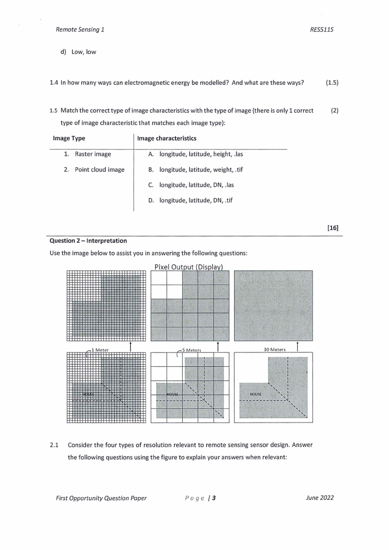
1.1 Using the image below answer the following questions based on it:
·v',--;..
D
\\,.) A I' '
'\\·
,/' /,/
E
t
,I l'
\\ //' B\\ ,B· //
- cj/
I
RES5115
a) Provide the correct labels, in your own words, for A-G in this image with respect to the
remote sensing process.
(3.S)
b) For each of the labelled points provide in one or two sentences a brief explanation about
(7)
how each of these points contribute to the remote sensing process
1.2 Select which single answer, in the correct order of words, you think will complete these
(1)
statements to make it true: An "Atmospheric Window" is a region of the spectrum where
incoming light is ____
and is not ____
by atmospheric particles. These windows
are regions, which in remote sensing, are used to study the properties of the ____
_
a) Transmitted, absorbed, atmosphere
b) Absorbed, transmitted, atmosphere
c) Transmitted, absorbed, earth's surface
d) Absorbed, transmitted, earth's surface
1.3 Select the correct choice which will complete this sentence to make it true: A short
(1)
wavelength has ____
frequency and ____
energy
a) High, low
b) High, high
c) Low, high
First Opportunity Question Paper
Page /2
June 2022
|
|
3 Page 3 |
▲back to top |
Remote Sensing 1
d) Low, low
RES5115
1.4 In how many ways can electromagnetic energy be modelled? And what are these ways?
(1.5)
1.5 Match the correct type of image characteristics with the type of image (there is only 1 correct
(2)
type of image characteristic that matches each image type):
Image Type
Image characteristics
1. Raster image
A. longitude, latitude, height, .las
2. Point cloud image
B. longitude, latitude, weight, .tif
C. longitude, latitude, DN, .las
D. longitude, latitude, DN, .tif
[16]
Question 2 - Interpretation
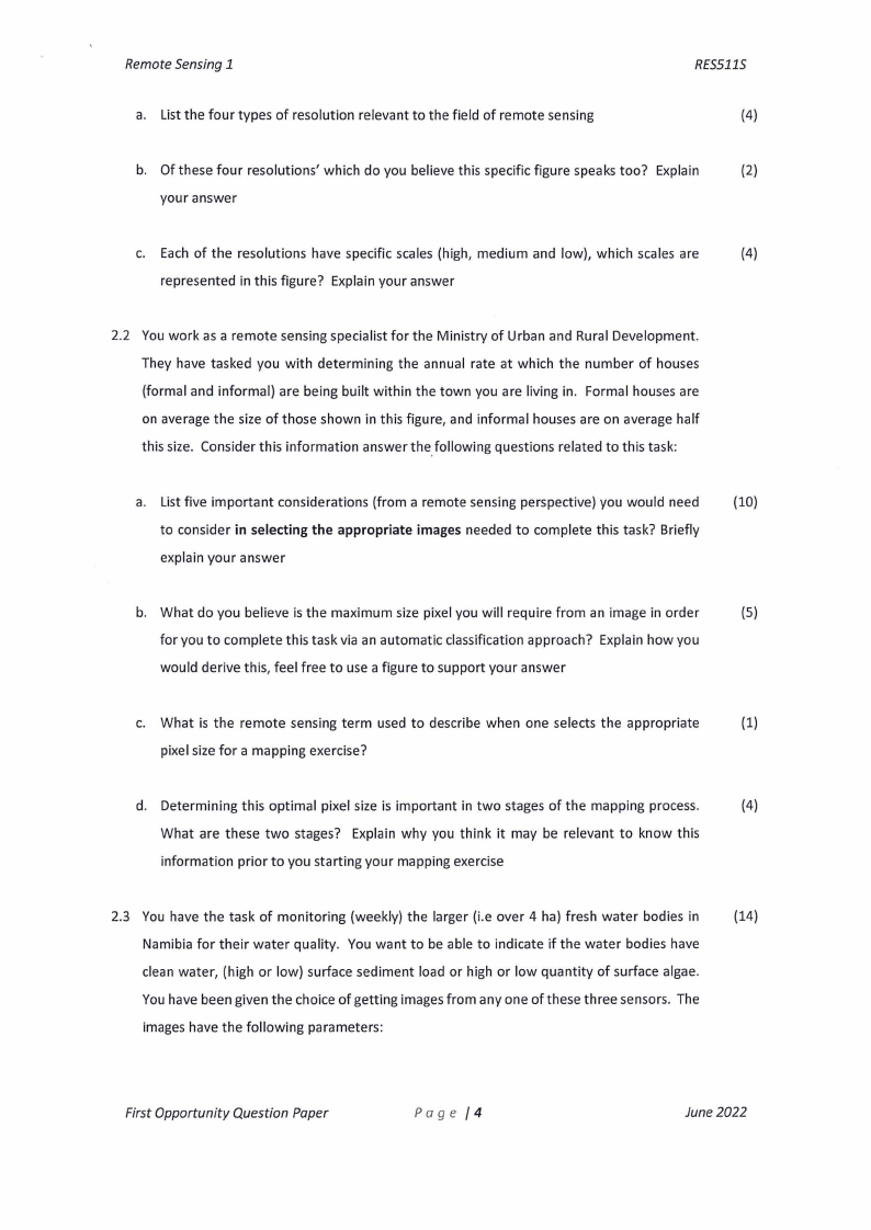
Use the image below to assist you in answering the following questions:
Pixel Output Displav)
-
"
'
-1 Meter
l
l l 5 Met-"rs,_,_
-- - I
30 Meters
I
I
I
I
·I I ,
I
I
I
I
I
Ir--
[
""
---
--' '-'-'
I
I
I
-:~,
'' '''
'
•I
',
I
• HOUSE
',, :
___ "',,
.......,_,_.....,......_ , ' ' ' -:.__
2.1 Consider the four types of resolution relevant to remote sensing sensor design. Answer
the following questions using the figure to explain your answers when relevant:
First Opportunity Question Paper
Page /3
June 2022
|
|
4 Page 4 |
▲back to top |
Remote Sensing 1
a. List the four types of resolution relevant to the field of remote sensing
RES5115
(4)
b. Of these four resolutions' which do you believe this specific figure speaks too? Explain
(2)
your answer
c. Each of the resolutions have specific scales (high, medium and low), which scales are
(4)
represented in this figure? Explain your answer
2.2 You work as a remote sensing specialist for the Ministry of Urban and Rural Development.
They have tasked you with determining the annual rate at which the number of houses
(formal and informal) are being built within the town you are living in. Formal houses are
on average the size of those shown in this figure, and informal houses are on average half
this size. Consider this information answer the_following questions related to this task:
a. List five important considerations (from a remote sensing perspective) you would need
(10)
to consider in selecting the appropriate images needed to complete this task? Briefly
explain your answer
b. What do you believe is the maximum size pixel you will require from an image in order
(5)
for you to complete this task via an automatic classification approach? Explain how you
would derive this, feel free to use a figure to support your answer
c. What is the remote sensing term used to describe when one selects the appropriate
(1)
pixel size for a mapping exercise?
d. Determining this optimal pixel size is important in two stages of the mapping process.
(4)
What are these two stages? Explain why you think it may be relevant to know this
information prior to you starting your mapping exercise
2.3 You have the task of monitoring (weekly) the larger (i.e over 4 ha) fresh water bodies in
(14)
Namibia for their water quality. You want to be able to indicate if the water bodies have
clean water, (high or low) surface sediment load or high or low quantity of surface algae.
You have been given the choice of getting images from any one of these three sensors. The
images have the following parameters:
First Opportunity Question Paper
Page /4
June 2022
|
|
5 Page 5 |
▲back to top |
Remote Sensing 1
RES511S
I. 25 bands evenly spaced between 400 - 1000 nm, 250 m pixel size, and re-images
each area daily
II. 25 bands evenly spaced between 400 - 2500 nm, 50 m pixel size, and re-images
each area every 3 days
Ill. 15 bands evenly spaced between 400 - 800 nm, 100 m pixel size, and re-images
each area every 7 days
Considering this background tabulate and discuss (with a figure too if it helps your
explanation) the pros and cons of each of these sensors linked to the specific defined task.
Use this information to indicate which of the sensors you would select to use for the task.
[44]
Question 3 - Calculations
2.1 You wish to acquire an image making use of a drone that will have a ground resolution of
(10)
4cm/pixel {IFOV). The camera to be used in the drone has a FOV of 54° and it produces
images that have an image resolution (w*h) of 1900*1450. Calculate the required flight
height (in ft) that is required to obtain this ground resolution. Would this flight be legal in
Namibia? Explain your answer. Show all your calculation steps
2.2 You have two spectrally subsetted level le Landsat 8 images (i.e. is already spectrally
subsetted and geometrically corrected) that you wish to compare to see if there has been
a change in the vegetation condition between these two images. Before you apply and
compare this over the entire image you decide you want to outline and test your method
by just testing on one known pixel in the two images to see if you can detect any differences.
You have the following information extracted from the image and the metadata file. Use
this information to answer the following questions:
a. What are the processing steps you think need to be carried out on the images to
(5)
conduct this type of analysis? Explain your answer as to why you believe these are
the relevant steps that need to be conducted.
b. If this subsetted file has 1340 columns and 1215 rows, and is a 14 bit unsigned
(7)
integer, what would its file size be in kb and Mb? NOTE:the final answer in kb and
First Opportunity Question Paper
Page /5
June 2022
|
|
6 Page 6 |
▲back to top |
Remote Sensing 1
Mb must be an integer. Show all your calculations
RES5115
c. What would the possible range of DN values be for a pixel in this file? Show how you
(3)
determined this.
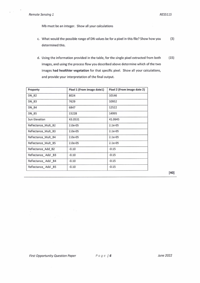
d. Using the information provided in the table, for the single pixel extracted from both
(15)
images, and using the process flow you described above determine which of the two
images had healthier vegetation for that specific pixel. Show all your calculations,
and provide your interpretation of the final output.
Property
DN_B2
DN_B3
DN_B4
DN_B5
Sun Elevation
Reflectance_Mult - B2
Reflectance_Mult_B3
Reflectance_Mult_B4
Reflectance_Mult_B5
Reflectance_Add_B2
Reflectance- Add - B3
Reflectance- Add - B4
Reflectance- Add - BS
Pixel 1 (From image datel)
8024
7629
6847
15228
43.0531
2.0e-05
2.0e-05
2.0e-05
2.0e-05
-0.10
-0.10
-0.10
-0.10
Pixel 2 (From image date 2)
10146
10952
12522
14995
41.0645
2.le-05
2.le-05
2.le-05
2.le-05
-0.15
-0.15
-0.15
-0.15
[40]
First Opportunity Question Paper
Page /6
June 2022