


 |
ODC721S - GEODESY - 2ND OPP - JAN 2024 |
|
|
1 Page 1 |
▲back to top |
n Am I BI A u n IVER s I TY
OF SCIEnCE Ano TECHnOLOGY
FACULTYOF ENGINEERINGAND THE BUILTENVIRONMENT
DEPARTMENTOF LANDAND SPATIALSCIENCES
QUALIFICATIONS:
BACHELOROF GEOMATICS
QUALIFICATIONSCODES:
07BGEO
COURSECODE:ODC721S
DATE: January 2024
DURATION: 3 HOURS
QUALIFICATIONLEVEL:
Level 7 - 07BGEO
COURSENAME: Geodesy
PAPER:THEORY
MARKS: 100
SECONDOPPORTUNITY\\ SUPPLEMENTARYEXAMINATION QUESTION PAPER
EXAMINER:
Mr J.C. Lewis
MODERATOR:
Dr K. Owolabi
INSTRUCTIONS
1. Answer all question.
2. Write clearly and neatly.
3. Number the answers clearly.
4. Make sure your Student Number is on the EXAMINATION BOOl<(s).
PERMISSiBLEMATERIAL
Calculator, ruler, pen
THIS QUESTION PAPERCONSISTSOF 3 PAGES(Including this front page)
|
|
2 Page 2 |
▲back to top |
Geodesy
ODC721S
1. Discussthe meaning and implications of Earth Tides, in the context of Geodesy.
(10 marks]
2. Discussthe meaning and major implications of the Vernal Equinox. Use a sketch if necessary.
(6 marks]
3. Explain the difference between a sphere, spheroid, and ellipsoid.
(4 marks]
4. Discussthe difference between a 'sidereal day' and a 'solar day'.
(5 marks]
5. Discussthe classification of coordinate systems used in Geodesy.
(10 marks]
6. Discussthe height system and vertical datum commonly used in Namibia. Briefly mention the
advantages and disadvantages of this system, compared to a more modern vertical datum.
(10 marks]
7. Briefly discuss the RA coordinate System.
(10 marks]
8. Briefly discuss the terms 'Geodetic Latitude', 'Astronomic Latitude,' and 'Deflection of the Vertical'.
Use a sketch if necessary.
(10 marks]
9. Explain how a national geodetic coordinate system is typically defined. How was this done for the
Namibian National Geodetic Datum?
(10 marks]
10. Explain and discuss meridian convergence. Your discussion should include an explanation of true
north, grid north, and geodetic azimuth, as well as a brief discussion of the use of and implications
of meridian convergence in land surveying.
(10 marks]
11. You have recorded the following observations from trig beacon Oaijobe, to unknown Point A, using
a gyro theodolite and EDM:
• Geodetic azimuth: 190°15'23"
• Horizontal distance: 7300.00m (international metre)
Discussand calculate the necessary corrections that must be applied to these observations, in order
to calculate the Lo2217 coordinates of Point A.
Note: You must calculate the final distance and direction that will be used for the polar calculation,
but you do not have to calculate the coordinates of Point A.
(15 marks]
Coordinates: {System: Lo2217}
Trig No. 29 (Daijobe):
Approximate coordinates of Point A:
Y+97 337.90
Y+98 600
X+672 615.20 MSL Elevation: 252.8m
X+679 800
MSL Elevation: 210m
Second Opportunity Question Paper
Page 2 of 3
January 2024
|
|
3 Page 3 |
▲back to top |
Geodesy
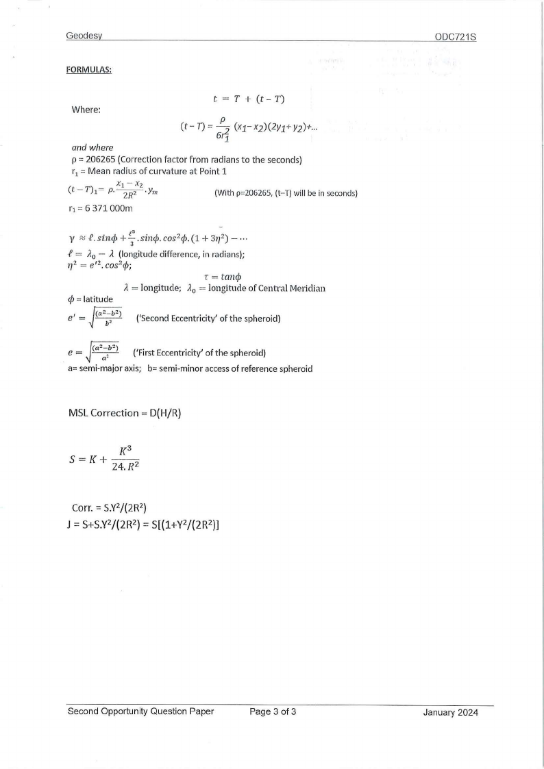
FORMULAS:
Where:
t = T + (t - T)
and where
p = 206265 (Correction factor from radians to the seconds)
r1 = Mean radius of curvature at Point 1
(t -T)1
=
p.
X1 -Xz
~-Ym
(With p=206265, (t-T) will be in seconds)
r1 = 6 371 000m
-
y e.sin</>+!:s.i.n.</>c.os 2 ¢. (1 + 31,2)- •••
3
-I!= Ao- ;i (longitude difference, in radians);
r,2 = e' 2. cos2¢;
r = tan</>
;i = longitude; Ao = longitude of Central Meridian
¢ = latitude
ff e'= -- 2
('Second Eccentricity' of the spheroid)
e = ff
('First Eccentricity' of the spheroid)
a= semi-major axis; b= semi-minor access of reference spheroid
MSL Correction= D(H/R)
ODC721S
Corr. = S.Y2/(2R 2)
J = S+S.Y2/(2R 2} = S[(1+Y2/(2R 2)]
Second Opportunity Question Paper
Page 3 of 3
January 2024