


 |
RES511S - REMOTE SENSING 1 - 2ND OPP - JULY 2022 |
|
|
1 Page 1 |
▲back to top |
nAmlBIA UnlVERSITY
OF SCIEnCE Ano
FACULTYOF ENGINEERINGAND SPATIALSCIENCES
DEPARTMENTOF ARCHITECTURE& SPATIALSCIENCES
QUALIFICATION(S): Bachelor of Geoinformation Technology; Diploma in Geomatics; Bachelor of
Geomatics
QUALIFICATION CODE (S): 07BGEI;
06DGEM;06DGEO;07BGEO
LEVEL: 5
COURSE CODE: RESSllS
COURSE NAME: REMOTESENSING1
SESSION: JULY2022
DURATION: 3 HOURS
PAPER: THEORY
MARKS: 100
SECOND OPPORTUNITY/SUPPLEMENTARY EXAMINATION QUESTION PAPER
EXAMINER:
Dr Nichola Knox
MODERATOR:
Ms Celeste Espach
INSTRUCTIONS
6. Answer ALL the questions.
7. Write clearly and neatly.
8. Number the answers clearly.
9. All calculations, unless otherwise specified, must be rounded off to the 3rd decimal.
10. For all calculations ensure that the formula's used are also provided in your answer.
PERMISSIBLE MATERIALS
3. All course material and written notes (Open-book examination)
4. Calculator, basic stationery
THIS QUESTION PAPER CONSISTS OF _5_ PAGES (Including this front page)
|
|
2 Page 2 |
▲back to top |
Remote Sensing 1
RES511S
Question 1- Short answer questions
1.1 Answer the following questions about satellite orbits:
a. What are the names and heights above the earth's surface of the three orbital height
(3)
regions that satellites can orbit in?
b. What are the primary satellite types that orbit at these different orbital heights? Provide
(6)
an example of one satellite platform that is currently operating in each of these different
orbital heights.
c. In which level/s of the atmosphere do each of these orbital heights occur?
(3)
1.2 Match the correct type of scattering to the description of how scattering occurs:
(3)
Scattering description
Types of scattering
1. Particles are smaller than the incoming radiation wavelength
A. Non-selective
2. Particles are about the same size as the incoming radiation
wavelength
B. Mie
3. Particles are larger than the incoming radiation wavelength
C. Specular
D. Diffuse
E. Raleigh
1.3 Select which option shows in the correct order correct examples associated with these three
(1)
application types of remote sensing: Terrestrial, Marine, and Atmospheric
a. Vegetation type detection, Weather forecasting, Sea Surface Temperature
b. Oil spill monitoring, cloud movement analysis, Chlorophyll a
c. Mineral mapping, current studies, rainfall monitoring
d. SST,LST,hurricane path modelling
[16]
Question 2 - Understanding & Interpretation
2.1 For this question, you will be required to use the two images (at the end of this script) and
Second Opportunity Question Paper
Page /2
JULY2022
|
|
3 Page 3 |
▲back to top |
Remote Sensing 1
RES511S
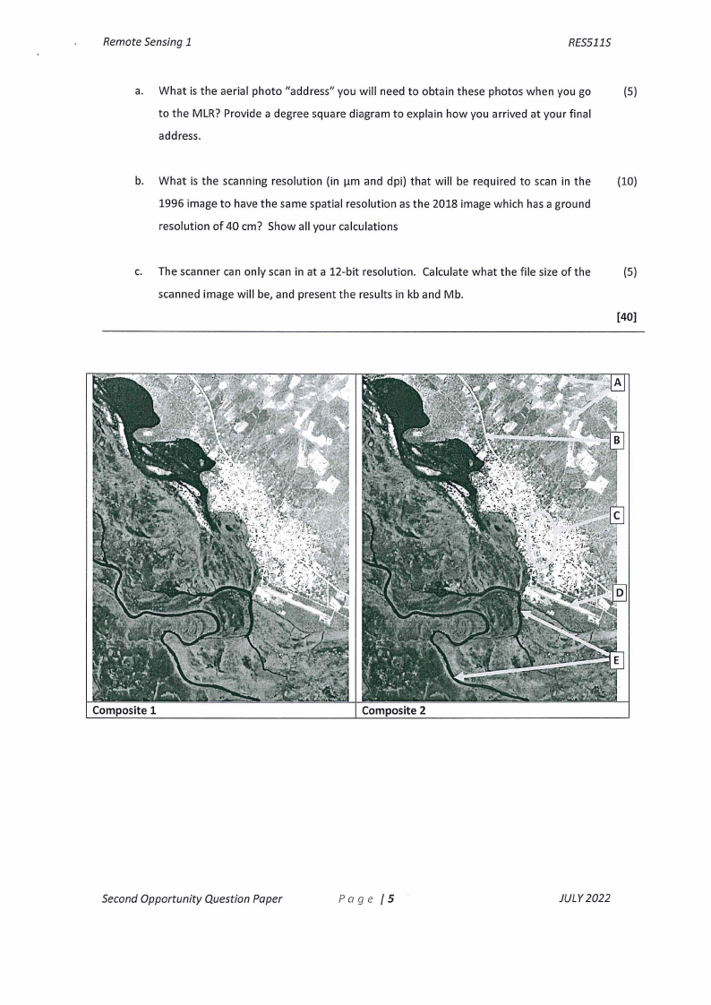
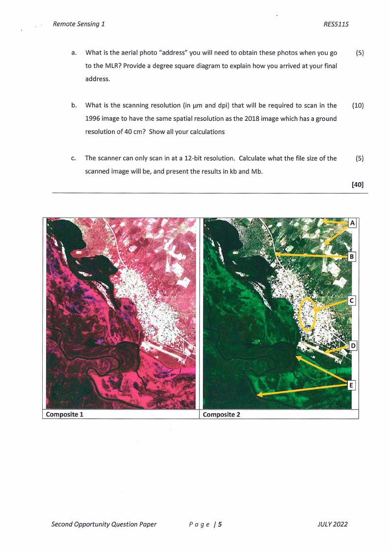
the information provided below to answer your questions. The colour composite images
provided were generated from a spectral and spatial subset of a Sentinel 2 image. The
image subset had 4 bands, and width of 490 columns and a height of 629 rows. The original
file name from this image was: "S2A_MSIL2A_20200415T081601_N0214_R121_ T34KFE"
a. Using Sentinel 2 as an example, explain in your own words what you understand about
the term a remote sensing platform and a remote sensing sensor?
(3)
b. Specifically which platform were these images acquired from? How did you determine
(2)
this?
c. What was the time and date when this image was acquired? How did you determine
(2)
this?
d. All four bands in the spectral subset are the same spatial resolution and different
(4)
combinations of bands were used to generate the different colour composite images.
Based on the 2 colour composite images provided below, which Sentinel 2 bands do you
believe are included in the image subset? Explain your answer.
e. Based on your above answer (2.ld), indicate what you believe the spatial resolution in
(2)
meters would be (no resampling is done on the original spectral bands) of these bands?
Explain how you arrived at this answer.
f. Based on the answer you provided in the above answer (2.le), calculate the image
(5)
footprint size (i.e. the length, width and area on the ground) that this image spatial
subset covered. Show how you calculated this, and express your answer in km/km 2•
g. Using the colour composites provided, at the end of the script, explain what is an image
(6)
colour composite. Identify what type of colour composites are provided, and explain (in
the order of the RGBchannels for creating displays) the order (i.e. which band is applied
to the red channel, etc) in which the spectral bands were applied to generate these
different colour composites.
h. In the Composite 2 image, provided at the end of this script, there are 5 terrestrial
(10)
features that have been pointed out (A-E). Identify what these features are, and explain
Second Opportunity Question Paper
Page /3
JULY 2022
|
|
4 Page 4 |
▲back to top |
Remote Sensing 1
RES511S
what specific image components you use to assist you in visually interpreting each of
them.
i. You download an image over this same area, once a month for 12 months in order to
(10)
determine at what times of the year cropping is taking place. Provide a basic outline on
what important processing steps will need to be done to these 12 images, and briefly
elaborate why you think these steps are necessary.
[44)
Question 3 - Calculations
3.1 Which has higher energy 420nm or 640THz? Show all your calculations (including formulas
(8)
and units) and explain your final answer.
3.2 You work at a company that flies and produces aerial photos. You have been requested to
fly a campaign to produce analogue aerial photos (standard size) at a scale of 1:15 000.
You will make use of a standard camera lens which has a focal length of 152 mm.
Considering this request answer the following questions and show all your calculations:
a. What is the height that you will have to fly at in order to produce this aerial photo?
(4)
Provide your answer in ft.
b. What area will be covered by a single photo? Provide your answer in km2•
(3)
c. How many photos will be required to fly an area that is 30 km long, and 6 km wide?
(5)
In your calculations, presume that you are not flying with any photo overlap, and
thus one photo can be immediately be placed directly alongside the next.
3.3 You wish to digitally compare an analogue aerial photo taken of Luderitz (Latitude: -26° 38'
53.02"5; Longitude: 15° 09' 33.98" E) in 1996 (1:35 000), and compare it with the digital
aerial photo taken in 2018, to determine how much growth has occurred in the town.
Considering this objective, answer the following questions and show all your calculations
used to derive your answers:
Second Opportunity Question Paper
Page /4
JULY2022
|
|
5 Page 5 |
▲back to top |
Remote Sensing 1
RES511S
a. What is the aerial photo "address" you will need to obtain these photos when you go
(5)
to the MLR? Provide a degree square diagram to explain how you arrived at your final
address.
b. What is the scanning resolution (in µm and dpi) that will be required to scan in the
(10)
1996 image to have the same spatial resolution as the 2018 image which has a ground
resolution of 40 cm? Show all your calculations
c. The scanner can only scan in at a 12-bit resolution. Calculate what the file size of the
(5)
scanned image will be, and present the results in kb and Mb.
[40]
Composite 1
Composite 2
Second Opportunity Question Paper
Page /5
JULY 2022
|
|
6 Page 6 |
▲back to top |
Remote Sensing 1
RES511S
a. What is the aerial photo "address" you will need to obtain these photos when you go
(5)
to the MLR? Provide a degree square diagram to explain how you arrived at your final
address.
b. What is the scanning resolution (in µm and dpi) that will be required to scan in the
(10)
1996 image to have the same spatial resolution as the 2018 image which has a ground
resolution of 40 cm? Show all your calculations
c. The scanner can only scan in at a 12-bit resolution. Calculate what the file size of the
(5)
scanned image will be, and present the results in kb and Mb.
[40)
Composite 1
Composite 2
Second Opportunity Question Paper
Page /5
JULY2022