


 |
GRS811S - GIS and REMORE SENSING IN PRACTICE - 2ND Opp - JULY 2022 |
|
|
1 Page 1 |
▲back to top |
nAmIBIA unIVERSITY
OF SCIEnCE Ano TECHn OLOGY
FACULTYOF HEALTH,APPLIEDSCIENCESAND NATURALRESOURCES
DEPARTMENTOF AGRICULTUREAND NATURALRESOURCES
QUALIFICATION: Bachelor of Natural Resource Management Honours
QUALIFICATION CODE: 09MNRM
LEVEL: 8
COURSECODE: GRS811S
COURSENAME: GISand remote sensing in practice
DATE:July 2022
PAPER: THEORY
DURATION: 3 Hours
MARKS: 85
SECONDOPPORTUNITY EXAMINATION QUESTION PAPER
EXAMINER(S)
MODERATOR:
Dr Vera De Cauwer
Ms Foibe Nelao Johannes
INSTRUCTIONS
l. Write clearly and neatly.
2. Number your answers clearly.
3. Make sure your student number appears on the answering script.
4. Include the formulas used for each calculation.
PERMISSIBLEMATERIALS
l. Calculator
THIS QUESTION PAPERCONSISTSOF 3 PAGES(Including this front page)
1
|
|
2 Page 2 |
▲back to top |

Question 1
[4]
What is the SMARTsystem? Explain briefly
Question 2
[16]
Convert the following coordinates to decimal format.
1. 16° 6.9' S, 23° 55.9' E
2. S 45° 45.6258', E 29° 15.5582'
3. 18° 19' 36" S, 21° 54' 2" W
4. S 28° 59', E 21° 8'
Question 3
[4]
Point A is situated at 19°55' S, 21°30' Eand point Bat 20°55' S,21°30' E.What is the distance in
metric units between the two points? Explain (and show your calculations)
Question 4
[2]
Why is the surveyed area by an UAV relatively small?
Question 5
[18]
Indicate if following statements are True or False. If false. correct the statement.
1. Electromagnetic radiation with a long wavelength has a low frequency.
2. X-rays contain more energy than radio waves.
3. Eachimage layer in a GIShas an attribute table.
4. Thermal radiation from the sun is emitted in the visible light range.
5. Green plants absorb green light.
6. Topography can be recorded by RADARsystems.
7. The distance between two meridians of longitude is a constant (always the same).
8. Coordinates of latitude represent the X-axis for the grid of latitude and longitude lines
covering the world.
9. Vector data can be imported into Google Earth if it is in klm format.
10. You can open a QGISproject (a file in qgz format) on a computer without having the GISdata
used in the project.
11. It is advised to always use illumination from the southwest to display hill shades on a map.
12. A contour line is a isopleth.
Question 6
[6]
What is cartography? Why is it such an important discipline?
Question 7
[3]
What is terrain relief? How can you display terrain relief on a map?
2
|
|
3 Page 3 |
▲back to top |
Question 8
[9]
Electromagnetic radiation consists of electromagnetic waves characterised by wavelength and
frequency.
1. Explain wavelength.
2. Explain frequency.
3. What is the relation between wavelength and frequency?
4. Give an example of electromagnetic radiation with a large wavelength.
5. Give an example of electromagnetic radiation with a high frequency.
Question 9
[S]
What is the difference between active and passive remote sensing sensors?
Question 10
(4]
What is the difference between geographical and projected coordinates?
Question 11
[9]
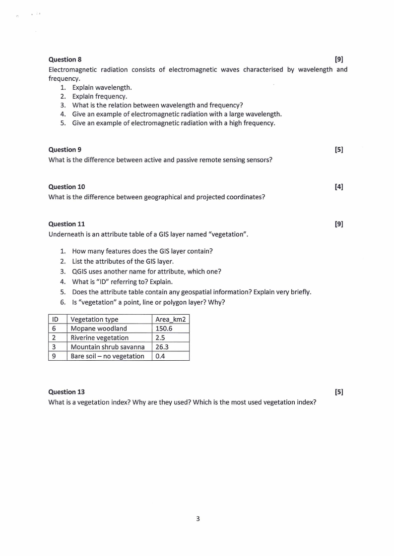
Underneath is an attribute table of a GIS layer named "vegetation".
1. How many features does the GISlayer contain?
2. List the attributes of the GISlayer.
3. QGISuses another name for attribute, which one?
4. What is "ID" referring to? Explain.
5. Does the attribute table contain any geospatial information? Explain very briefly.
6. Is "vegetation" a point, line or polygon layer? Why?
ID Vegetation type
Area km2
6 Mopane woodland
150.6
2 Riverine vegetation
2.5
3 Mountain shrub savanna 26.3
9 Bare soil - no vegetation 0.4
Question 13
[S]
What is a vegetation index? Why are they used? Which is the most used vegetation index?
3