


 |
BSV521S - BASIC SURVEYING - 1ST OPP - JUNE 2023 |
|
|
1 Page 1 |
▲back to top |
i·
nAmlBIA unlVERSITY
OF SCIEnCE Ano TECHnOLOGY
FACULTY OF ENGINEERING AND THE BUILT ENVIRONMENT
DEPARTMENT OF LAND AND SPATIAL SCIENCES
QUALIFICATIONS:
BACHELOROF GEOMATICS and DIPLOMA IN GEOMATICS
QUALIFICATIONS CODES:
07BGEO,06DGEO
QUALIFICATION LEVEL:
Level 7 - 07BGEO
Level 6 - 06DGEO
COURSE CODE: BSV521
COURSE NAME: Basic Surveying
DATE: June 2023
PAPER: THEORY
DURATION: 3 HOURS
MARKS: 100
EXAMINER:
MODERATOR:
FIRST OPPORTUNITY EXAMINATION QUESTION PAPER
Mr F. J. Louw
Mr S. Sinvula
INSTRUCTIONS
1. You MUST answer ALL QUESTIONS
2. Write clearly and neatly.
3. Number the answers clearly.
4. Make sure your Student Number is on the EXAMINATION BOOK(s).
5. MAKE SURE YOUR STUDENT NUMBER IS ON THE DATA SHEET AND
THAT YOU SUBMIT IT WITH YOUR EXAMINATION BOOK(S).
PERMISSIBLE MATERIALS
1. Calculator, ruler, pen, pencil, and eraser.
THIS QUESTION PAPER CONSISTS OF 8 PAGES (Including this front page and 3 Data Sheets)
|
|
2 Page 2 |
▲back to top |
Basic Surveying
BSV521S
Question 1
1.1. Surveying can be divided into fieldwork and office work, briefly explain BOTH.
(4)
1.2. List the TWO principal classifications of surveying. Fully explain BOTH.
(7)
1.3. Setting out is the process of using surveying equipment and techniques to transfer information
from a plan to the ground. Describe the THREEdistinct elements of setting out.
(3)
1.4. Briefly explain the FOURimportant aspects of a resection.
(4)
1.5. Briefly describe the term "Trigonometrical Levelling".
(2)
[20]
Question 2
2.1. Use the levelling observations given in Data Sheet 1 or Data Sheet 2 to determine the final heights
using ANYMETHODwhich provides a full arithmetic check. All usual checks must be done, and any
mis-closures need to be distributed. Please detach the data sheet and submit it with your
examination book.
(10)
2.2. Use the field observations at K15, to calculate the final observed directions.
(5)
@K15 HI= 1.655m
Point
Circle Left
Circle Right
f1CC
299° 02' 38"
119° 02' 34"
K2
309° 48' 06"
129° 47' 55"
Gate
255° 14' 53"
75° 15' 03"
f1RCCS
271° 46' 42"
91° 46' 44"
RO
299° 02' 33"
119° 02' 31"
2.3. Use the information below to calculate the final vertical directions at point K15.
(5)
@K15 HI= 1.655m
Point
Circle Left
Circle Right
f1CC
85° 56' 58"
274° 03' 08"
K2
92° 49' 17"
267° 10' 37"
Gate
94° 05' 59"
265° 54' 05"
[20]
First Opportunity Question Paper
Page 2 of 8
June 2023
|
|
3 Page 3 |
▲back to top |
Basic Surveying
BSV521S
Question 3
3.1. Use the following Formula and the observations at RPl, to answer the questions that follow.
Please note:
The Instrument Correction and Prism Constant, the Atmospheric Correction, and the Conversion to
German Legal Metre are already applied to all measured distances.
Combined Sea level & Scale Enlargement Factor= l+ [{y2/{2R2})-{H/R)], where R= 6 370km.
Coordinates
Name
fl cc
fl cc
V
- 9 053.130
- 8 555.090
X
+ 62 813.860
+ 62 481.930
Height
RPl
- 8 146.180 + 62 570.831
1666.665
.@..B.e1
Height of the Instrument is 1.658m .
Name
Final Observed Direction
Slope Distance
Zenith Angle
fl RCCS
fl cc
257° 44' 11"
285° 00' 07"
87° 45' 48"
as·45' 48"
Pl
323° 19' 48"
20.825m
91° 35' 35"
3.1.1.
3.1.2.
Calculate and apply all corrections to observations at RPl {directions & distances). {11)
Calculate the coordinates for Pl.
{4)
3.2. Use the following Formula to calculate the height of Hl.
{4)
~Hab= H1- Hsig+ Sab/Tan{Z) + {1-k).52/ {2R)
Ha= Hb- ~Hab
R = 6 370 000m)
k = 0.13
Co-ordinates
Point
V
X
z
fl EROS
-10 489.688
+60 272.255 1 810.685 {Ground Level)
The JOIN distance from Hl to f:J.EROSis 4104.000m
.@J:!!
HI= 1.780m
Point
Zenith Angle Height of Pillar
fl EROS
87° 46' 45"
1.200m {Top of Pillar)
[20]
First Opportunity Question Paper
Page 3 of 8
June 2023
|
|
4 Page 4 |
▲back to top |
Basic Surveying
BSV521S
Question 4
4.1. Calculate the final coordinates for the traverse points on Data Sheet 3. Use the said data sheet for
all your calculations. Use the Bowditch Rule to adjust the traverse. Please note that the directions
are oriented, and the distances are final horizontal distances. Please detach the data sheet and
submit it with your examination book.
(10)
4.2. Use the following observations at NEW, to calculate the Y and X coordinates for NEW.
(10)
Please note:
The Prism Constant, the Atmospheric Correction, the Conversion to German Legal Metre, and the
Combined Sea level & Scale Enlargement Scale Factor correction are already applied to all measured
distances.
Co-ordinates
Name
t:,.Moltke
ZB3214
y
-18 508.640
-26 178.133
X
+72 023.020
+60 627.395
Height
1800.000
@NEW
Point/Station
t:,.Moltke
ZB3214
HI= 1.655m
Final Observed Direction
29° 23' 01"
110° 54' 10"
Final Horizontal Distance
190.613m
Zenith Angle
87°35'28"
91 °07'32 II
[20)
Question 5
5.1. Use the information and observations below to calculate the coordinates for the point TOP, by
using the Q-point method of a resection calculation.
(20)
Co-ordinates
Name
y
X
!::,.OLYMPIA - 9 728.580 + 66 201.950
t:,.SWP
- 4 680.110 + 62 348.570
t:,.WACHTER - 13 105.120 + 52 799.350
First Opportunity Question Paper
Page 4 of 8
June 2023
|
|
5 Page 5 |
▲back to top |
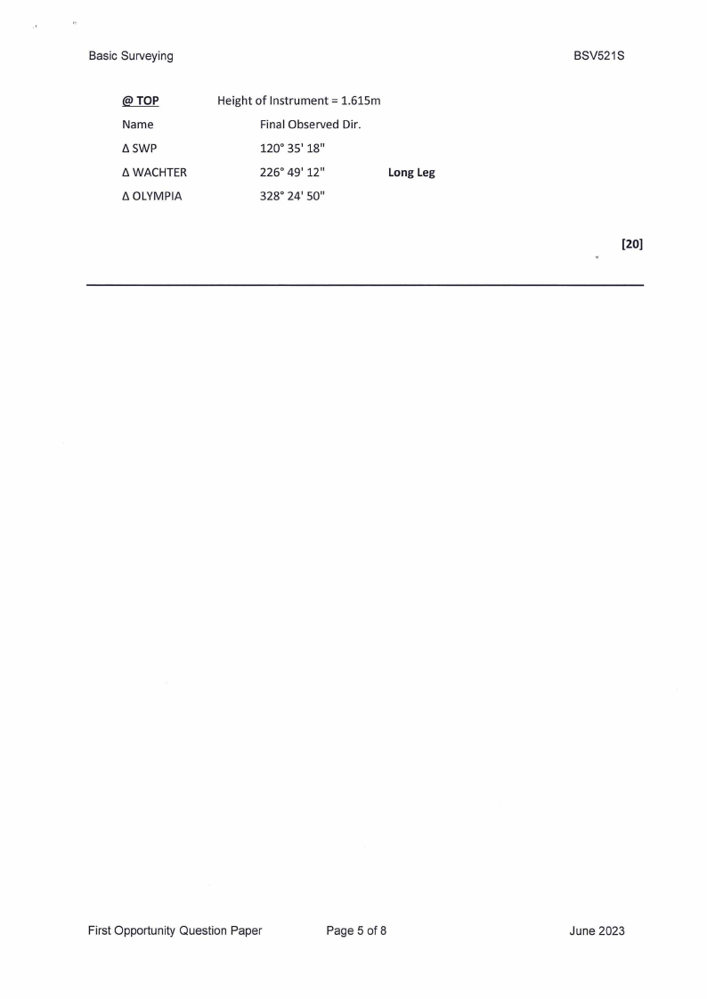
Basic Surveying
@TOP
Name
{). SWP
{). WACHTER
{). OLYMPIA
Height of Instrument= 1.615m
Final Observed Dir.
120° 35' 18"
226° 49' 12"
Long Leg
328° 24' 50"
BSV521S
[20)
First Opportunity Question Paper
Page 5 of 8
June 2023
|
|
6 Page 6 |
▲back to top |
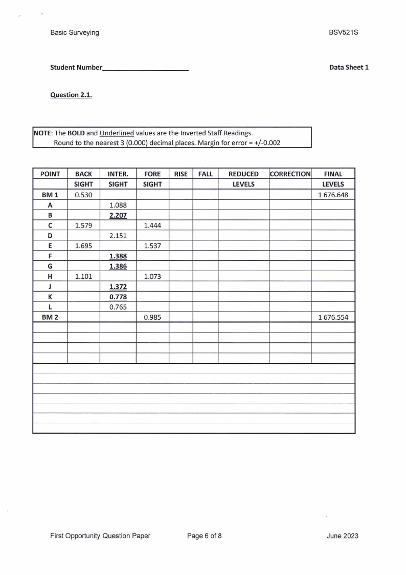
Basic Surveying
Student Number________
_
Question 2.1.
BSV521S
Data Sheet 1
NOTE: The BOLD and Underlined values are the Inverted Staff Readings.
Round to the nearest 3 {0.000) decimal places. Margin for error= +/-0.002
POINT
BMl
A
B
C
D
E
F
G
H
J
K
L
BM2
BACK
SIGHT
0.530
1.579
1.695
1.101
INTER.
SIGHT
1.088
2.207
2.151
1.388
1.386
1.372
0.778
0.765
FORE
SIGHT
RISE FALL
1.444
1.537
1.073
0.985
REDUCED
LEVELS
CORRECTION FINAL
LEVELS
1676.648
1676.554
First Opportunity Question Paper
Page 6 of 8
June 2023
|
|
7 Page 7 |
▲back to top |
Basic Surveying
Student Number ________
_
Question 2.1.
BSV521S
Data Sheet 2
NOTE: The BOLD and Underlined values are the Inverted Staff Readings.
Round to the nearest 3 (0.000) decimal places. Margin for error= +/-0.002
POINT
BMl
A
B
C
D
E
F
G
H
J
K
L
BM2
BACK
SIGHT
0.530
1.579
1.695
1.101
INTER.
SIGHT
1.088
2.207
2.151
1.388
1.386
1.372
0.778
0.765
FORE
SIGHT
1.444
1.537
1.073
0.985
COLL.
HEIGHT
REDUCED
LEVELS
CORRECTION
FINAL
LEVELS
1676.648
1676.554
First Opportunity Question Paper
Page 7 of 8
June 2023
|
|
8 Page 8 |
▲back to top |
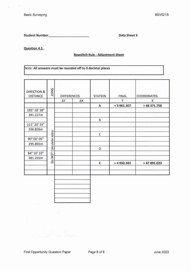
Basic Surveying
BSV521S
Student Number _________
_
Data Sheet 3
Question 4.1.
Bowditch Rule - Adjustment Sheet
Note: All answers must be rounded off to 3 decimal places
DIRECTION& Vzl
DISTANCE
0-,
DIFFERENCES
tJ.Y
tJ.X
185° 18' 38"
391.227m
111° 20' 33"
356.826m
1/)
·Co:
-,
90° 00' 05"
.(I.)...
295.892m
:u::l
uro
84° 10' 10"
381.265m
I-
0z
0
0
STATION
A
FINAL
y
+ 3 961.307
COORDINATES
X
+ 68 371.758
B
C
D
E
+ 4 932.565
+ 67 891.023
First Opportunity Question Paper
Page 8 of 8
June 2023