


 |
BSV521S - BASIC SURVEYING - 2ND OPP - JULY 2025 |
|
|
1 Page 1 |
▲back to top |
nAmlBIA unlVERSITY
OF SCIEnCE Ano TECHnOLOGY
FACULTYOF ENGINEERINGAND THE BUILTENVIRONMENT
DEPARTMENTOF LANDAND SPATIALSCIENCES
QUALIFICATIONS:
BACHELOROF GEOMATICS and DIPLOMA IN GEOMATICS
QUALIFICATIONSCODES:
07BGEO,06DGEO
QUALIFICATION LEVEL:
Level 7 - 07BGEO
Level 6 - 06DGEO
COURSENAME: Basic Surveying
COURSECODE:BSV521S
COURSELEVEL:5
DATE: July 2024
PAPER:THEORY
DURATION: 3 HOURS
MARKS: 100
SECONDOPPORTUNITY/SUPPLEMENTARYEXAMINATION QUESTION PAPER
EXAMINER:
Mr Frikkie Louw
MODERATOR:
Dr JosephOdumosu
INSTRUCTIONS
1. You MUST answer ALLQUESTIONS
2. Write clearly and neatly.
3. Number the answers clearly.
4. Make sure your Student Number is on the EXAMINATION BOOK(s}.
5. MAKE SUREYOUR STUDENTNUMBER IS ON ALLTHE DATA SHEETSAND
THAT YOU SUBMIT THEM WITH YOUR EXAMINATION BOOK(S).
PERMISSIBLEMATERIALS
1. Calculator, ruler, pen, pencil, and eraser.
THIS QUESTION PAPERCONSISTSOF 7 PAGES(Including this front page and 2 Data Sheets}
|
|
2 Page 2 |
▲back to top |
Basic Surveying
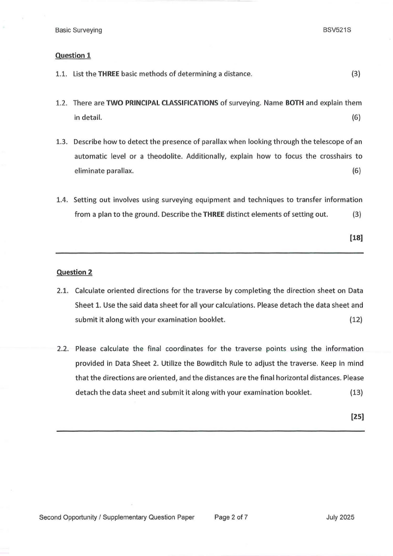
Question 1
1.1. List the THREEbasic methods of determining a distance.
BSV521S
(3)
1.2. There are TWO PRINCIPALCLASSIFICATIONSof surveying. Name BOTH and explain them
in detail.
(6)
1.3. Describe how to detect the presence of parallax when looking through the telescope of an
automatic level or a theodolite. Additionally, explain how to focus the crosshairs to
eliminate parallax.
(6)
1.4. Setting out involves using surveying equipment and techniques to transfer information
from a plan to the ground. Describe the THREEdistinct elements of setting out.
(3)
[18]
Question 2
2.1. Calculate oriented directions for the traverse by completing the direction sheet on Data
Sheet 1. Use the said data sheet for all your calculations. Please detach the data sheet and
submit it along with your examination booklet.
(12)
2.2. Please calculate the final coordinates for the traverse points using the information
provided in Data Sheet 2. Utilize the Bowditch Rule to adjust the traverse. Keep in mind
that the directions are oriented, and the distances are the final horizontal distances. Please
detach the data sheet and submit it along with your examination booklet.
(13)
[25]
SecondOpportunity/ SupplementaryQuestionPaper
Page 2 of 7
July 2025
|
|
3 Page 3 |
▲back to top |
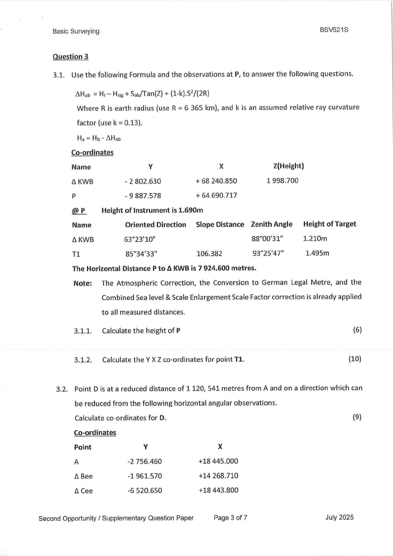
Basic Surveying
BSV521S
Question 3
3.1. Use the following Formula and the observations at P, to answer the following questions.
~Hab = H1- Hsig+ Sab/Tan(Z)+ {1-k).S2/{2R)
Where R is earth radius (use R = 6 365 km), and k is an assumed relative ray curvature
factor (use k = 0.13).
Ha= Hb- ~Hab
Co-ordinates
Name
/::.KWB
p
V
- 2 802.630
- 9 887.578
X
+ 68 240.850
+ 64 690.717
Z(Height)
1 998.700
@_.e_ Height of Instrument is 1.690m
Name
Oriented Direction Slope Distance Zenith Angle
t:.KWB
63°23'10"
88°00'31"
Tl
85°34'33"
106.382
93°25'47"
Height of Target
1.210m
1.495m
The Horizontal Distance P to fl KWB is 7 924.600 metres.
Note: The Atmospheric Correction, the Conversion to German Legal Metre, and the
Combined Sea level & Scale Enlargement Scale Factor correction is already applied
to all measured distances.
3.1.1. Calculate the height of P
(6)
3.1.2. Calculate the Y X Z co-ordinates for point Tl.
(10)
3.2. Point D is at a reduced distance of 1120, 541 metres from A and on a direction which can
be reduced from the following horizontal angular observations.
Calculate co-ordinates for D.
(9)
Co-ordinates
Point
V
X
A
-2 756.460
+18 445.000
/::.Bee
-1 961.570
+14 268.710
I::.Cee
-6 520.650
+18 443.800
Second Opportunity / Supplementary Question Paper
Page 3 of 7
July 2025
|
|
4 Page 4 |
▲back to top |
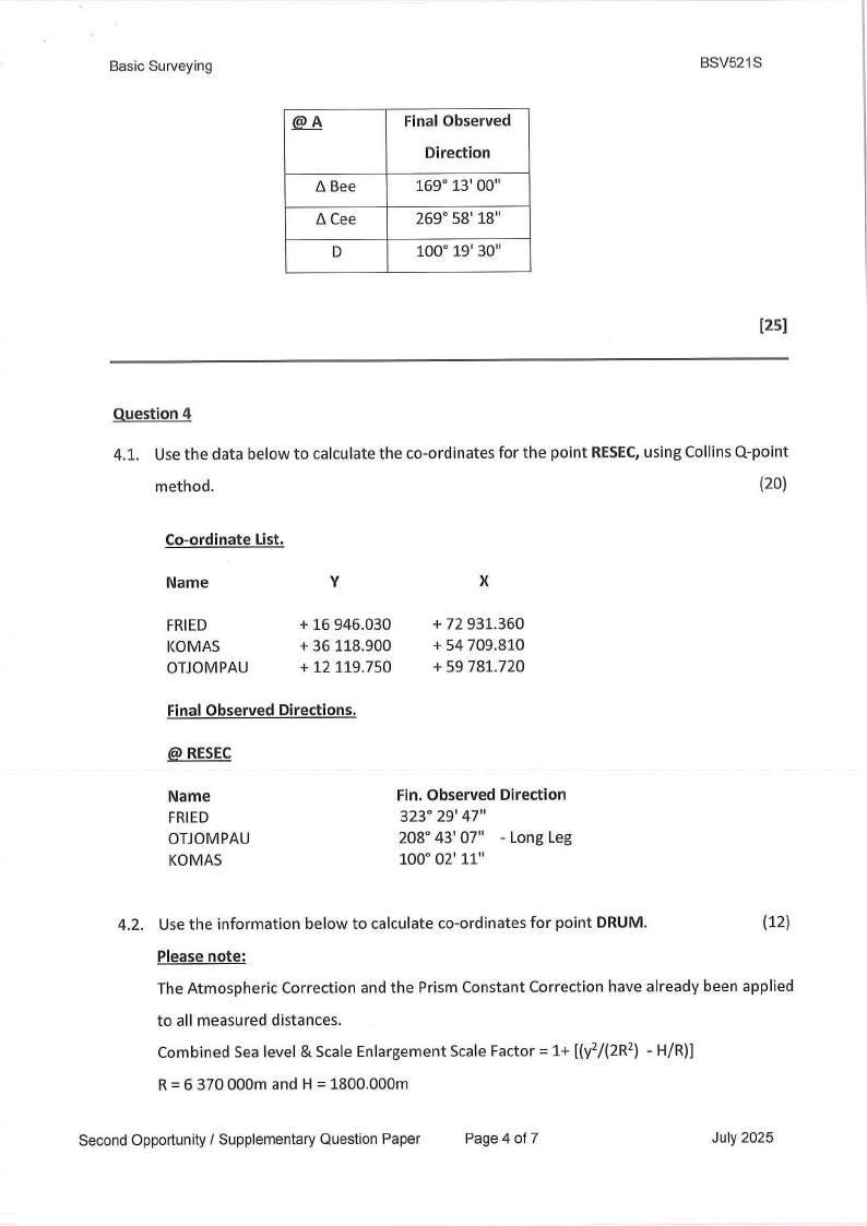
Basic Surveying
@._8
fl Bee
fl Cee
D
Final Observed
Direction
169° 13' 00"
269° 58' 18"
100° 19' 30"
BSV521S
[25]
Question 4
4.1. Use the data below to calculate the co-ordinates for the point RESECu, sing Collins Q-point
method.
(20)
Co-ordinate List.
Name
V
X
FRIED
KOMAS
OTJOMPAU
+ 16 946.030
+ 36 118.900
+ 12 119.750
+ 72 931.360
+ 54 709.810
+ 59 781.720
Final Observed Directions.
@ RESEC
Name
FRIED
OTJOMPAU
KOMAS
Fin. Observed Direction
323° 29' 47"
208° 43' 07'' - Long Leg
100° 02' 11"
4.2. Use the information below to calculate co-ordinates for point DRUM.
(12)
Please note:
The Atmospheric Correction and the Prism Constant Correction have already been applied
to all measured distances.
Combined Sea level & Scale Enlargement Scale Factor= 1+ [(y2/(2R 2) - H/R)]
R = 6 370 000m and H = 1800.000m
Second Opportunity/ Supplementary Question Paper
Page 4 of 7
July 2025
|
|
5 Page 5 |
▲back to top |
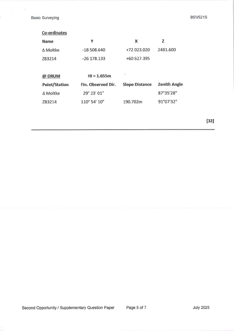
Basic Surveying
Co-ordinates
Name
ClMoltke
ZB3214
y
-18 508.640
-26 178.133
BSV521S
X
+72 023.020
+60 627.395
z
2481.600
@DRUM
Point/Station
fl Moltke
ZB3214
HI= 1.655m
Fin. Observed Dir.
29° 23' 01"
110° 54' 10"
Slope Distance
190.702m
Zenith Angle
87°35'28"'
91°07'32"
[32)
Second Opportunity/ Supplementary Question Paper
Page 5 of 7
July 2025
|
|
6 Page 6 |
▲back to top |
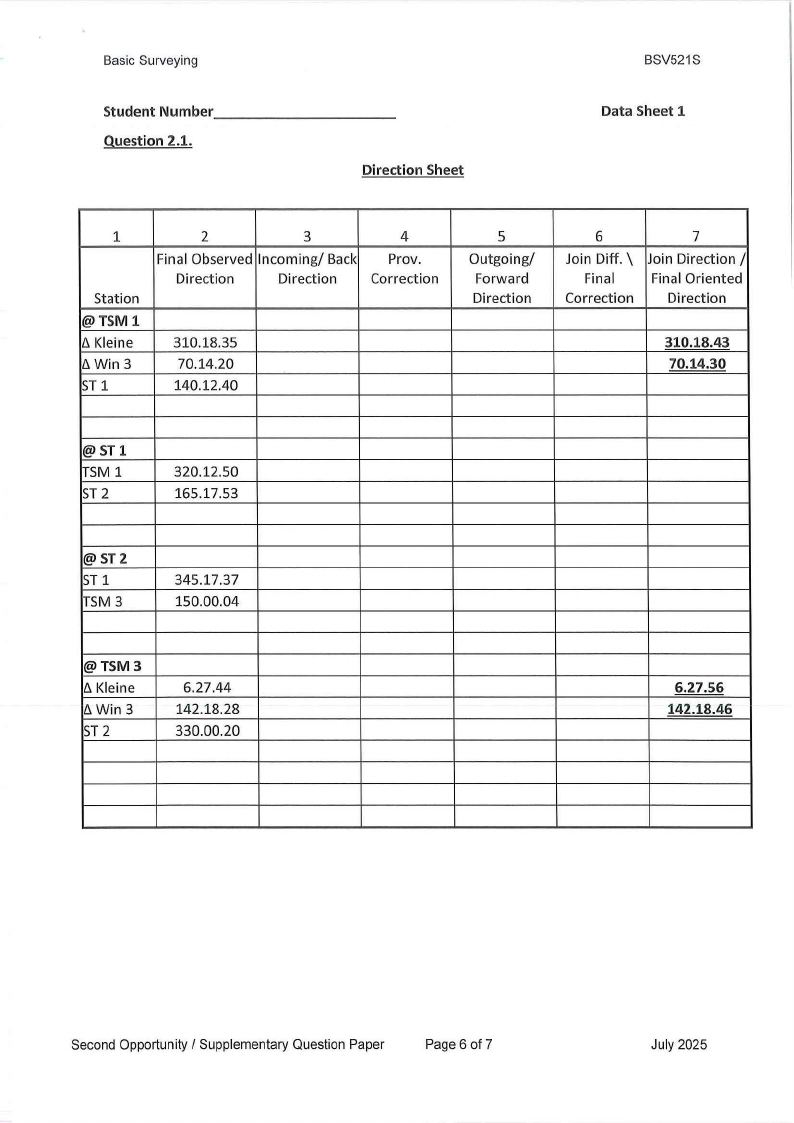
Basic Surveying
Student Number ----------
Question 2.1.
Direction Sheet
BSV521S
Data Sheet 1
1
Station
@TSM1
/j, Kleine
fj,Win3
ST 1
2
3
4
Final Observed Incoming/ Back Prov.
Direction
Direction
Correction
310.18.35
70.14.20
140.12.40
5
Outgoing/
Forward
Direction
6
Join Diff. \\
Final
Correction
7
Join Direction /
Final Oriented
Direction
310.18.43
70.14.30
@ST1
TSM 1
ST 2
320.12.50
165.17.53
@ST2
ST 1
TSM 3
345.17.37
150.00.04
@TSM3
/j, Kleine
/j, Win 3
ST 2
6.27.44
142.18.28
330.00.20
6.27.56
142.18.46
Second Opportunity/ Supplementary Question Paper
Page 6 of 7
July 2025
|
|
7 Page 7 |
▲back to top |
Basic Surveying
BSV521S
Student Number ----------
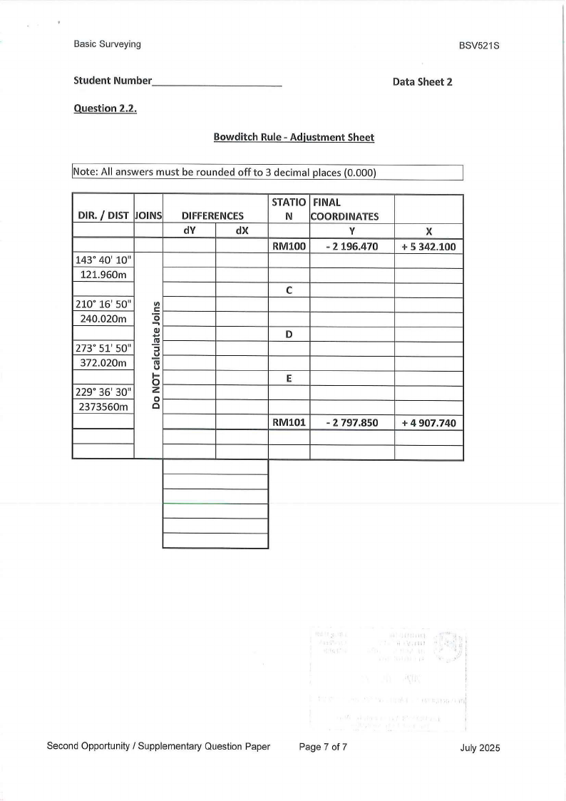
Question 2.2.
Data Sheet 2
Bowditch Rule - Adjustment Sheet
!Note: All answers must be rounded off to 3 decimal places (0.000)
DIR./ DIST JOINS
DIFFERENCES
dY
dX
143° 40' 10"
121.960m
210° 16' 50"
240.020m
VI
·..CQo..J: ..
273° 51' 50"
..!!!
:u:I
372.020m
nu ,
I-
229° 36' 30"
0z
0
2373560m
0
STATIC FINAL
N COORDINATES
V
RMl00
- 2196.470
C
D
E
RM101 - 2 797.850
X
+ 5 342.100
+ 4 907.740
11'
Second Opportunity / Supplementary Question Paper
Page 7 of 7
July 2025