


 |
BSV521S - BASIC SURVEYING - 2ND OPP - JAN 2020 |
|
|
1 Page 1 |
▲back to top |
NAMIBIA UNIVERSITY
OF SCIENCE AND TECHNOLOGY
FACULTY OF NATURAL RESOURCES AND SPATIAL SCIENCES
DEPARTMENT OF GEO-SPATIAL SCIENCES AND TECHNOLOGY
QUALIFICATIONS:
DIPLOMA IN GEOMATICS
BACHELOR OF GEOMATICS
QUALIFICATIONS CODES:
O6DGEM
07BGEM
COURSE LEVEL:
Level 5
COURSE CODE: BSV521S
COURSE NAME: Basic Surveying
SESSION: January 2020
DURATION: 3 HOURS
PAPER: Theory
MARKS: 100
SECOND OPPORTUNITY/SUPPLEMENTARY EXAMINATION QUESTION PAPER
EXAMINER:
Mr F. J. Louw
MODERATOR:
Mr S. E. Sinvula
INSTRUCTIONS
You MUST answer ALL the questions.
Write clearly and neatly.
Number the answers clearly.
Make sure your Student Number is on the EXAMINATION BOOK(s).
Make sure your Student Number is on all the Data Sheets and that
you submit them with your EXAMINATION BOOK(s).
PERMISSIBLE MATERIALS
1. Calculator, ruler, pencil and eraser.
THIS QUESTION PAPER CONSISTS OF 7 PAGES (Including this front page and 2 Data Sheets)
|
|
2 Page 2 |
▲back to top |
Basic Surveying
BSV521S
Question 1
1.1. Explain the following with neat sketches:
1.1.1. The three methods to measure a distance using a measuring tape.
(6)
1.1.2. Precise observations and accurate observations.
(4)
1.1.3.
Indicating the directions of increasing and decreasing of the co-ordinate values
for both Y and X for the Namibian coordinate systems.
(4)
1.2. Briefly describe ANY FOUR characteristics of Contours.
(4)
1.3. Why should intermediate sights onto important points be avoided in levelling?
(2)
[20]
Question 2
2.1. Calculate the traverse on Data Sheet 1. Use the said Data Sheet for all your calculations.
Use the Bowditch Rule to adjust the traverse. Please note that the directions are
oriented, and the distances are final.
(10)
2.2. Calculate oriented directions for the traverse by completing the direction sheet on Data
Sheet 2. Use the said Data Sheet for all your calculations.
(10)
[20]
2"4 Opportunity/Supplementary Question Paper
Page 2 of 7
January 2019
|
|
3 Page 3 |
▲back to top |
Basic Surveying
BSV521S
Question 3
Calculate the Y X Z co-ordinates for point $T101, by using the following information and the
observations at ST101.
(22)
AHab = Hi— Hsig + Sab/Tan(Z) + (1-k).S2/(2R)
Where R is earth radius (use R = 6 370 km), and k is an assumed relative ray curvature
factor (use k = 0.13).
Ha = Hp - AHab
Please note:
The Atmospheric Correction, the Conversion to German Legal Metre, and the Combined
Sea level & Scale Enlargement Scale Factor correction are already applied to all
measured distances.
Co-ordinates
Name
Y
ATare
+101 871.540
WP1
+101 456.605
X
+27 439.710
+32 040.196
Z
1685.150
Description
Top of Pillar
Working Station
@ ST101
Point
ATare
WP1
Height of Instrument is 1.785m
Fin. Observed Dir. Slope Distance Zenith Angle Height Target
163°31'26"
88°02'50"
0.000m
359°58'55"
376.252m
91°15'27"
2.055m
[22]
24 Opportunity/Supplementary Question Paper
Page 3 of 7
January 2019
|
|
4 Page 4 |
▲back to top |
Basic Surveying
BSV521S
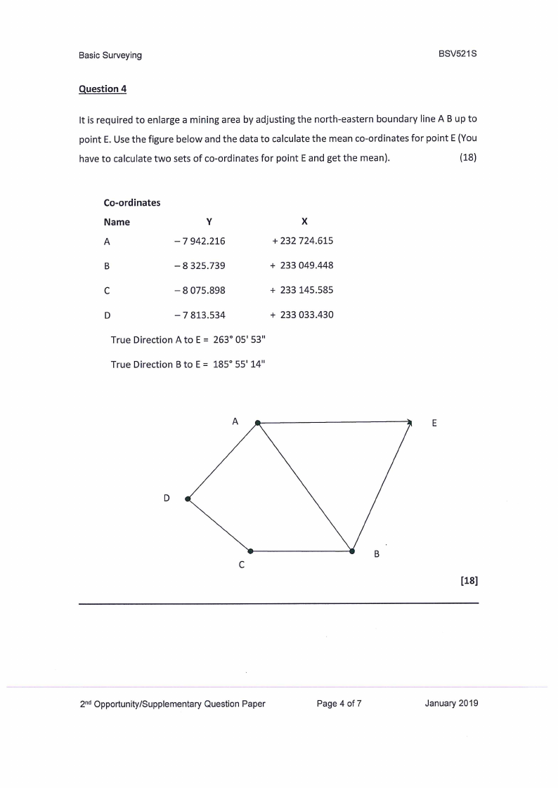
Question 4
It is required to enlarge a mining area by adjusting the north-eastern boundary line A B up to
point E. Use the figure below and the data to calculate the mean co-ordinates for point E (You
have to calculate two sets of co-ordinates for point E and get the mean).
(18)
Co-ordinates
Name
A
Y
—7 942.216
x
+ 232 724.615
B
— 8 325.739
+ 233 049.448
C
— 8 075.898
+ 233 145.585
D
— 7 813.534
+ 233 033.430
True Direction A to E = 263° 05' 53"
True Direction B to E= 185° 55'14"
[18]
2"4 Opportunity/Supplementary Question Paper
Page 4 of 7
January 2019
|
|
5 Page 5 |
▲back to top |
Basic Surveying
BSV521S
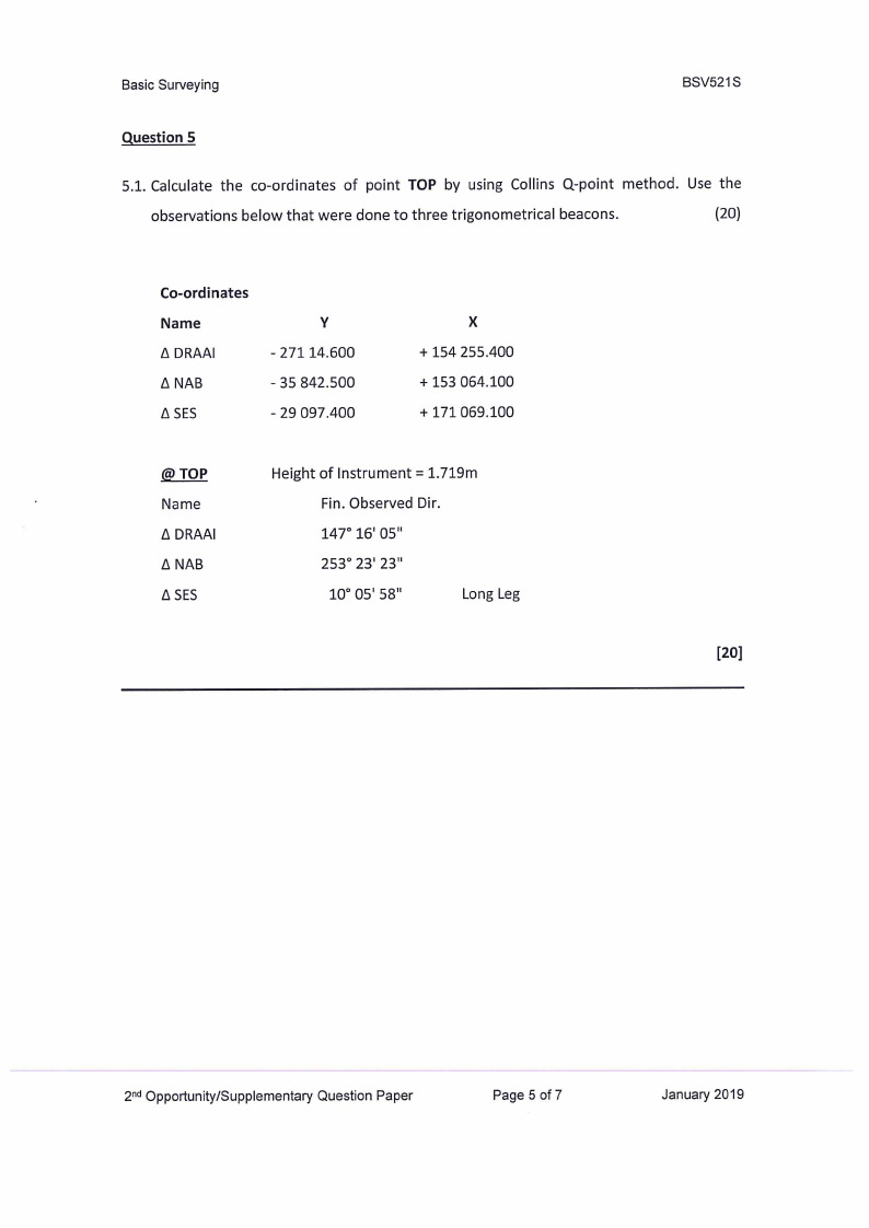
Question 5
5.1. Calculate the co-ordinates of point TOP by using Collins Q-point method. Use the
observations below that were done to three trigonometrical beacons.
(20)
Co-ordinates
Name
A DRAAI
A NAB
A SES
Y
- 271 14.600
- 35 842.500
- 29 097.400
X
+ 154 255.400
+ 153 064.100
+ 171 069.100
@ TOP
Name
A DRAAI
A NAB
A SES
Height of Instrument = 1.719m
Fin. Observed Dir.
147° 16' 05"
253° 23' 23"
10° 05' 58"
Long Leg
[20]
2°4 Opportunity/Supplementary Question Paper
Page 5 of 7
January 2019
|
|
6 Page 6 |
▲back to top |
Basic Surveying
Student Number:
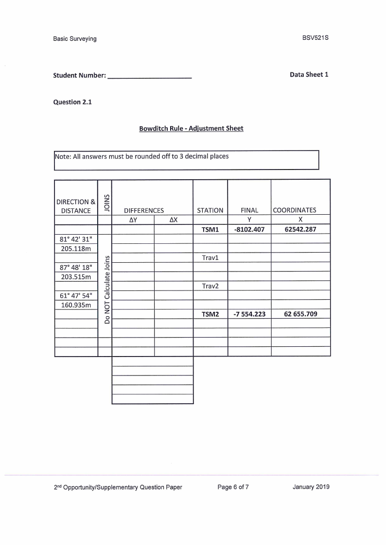
Question 2.1
Bowditch Rule - Adjustment Sheet
Note: All answers must be rounded off to 3 decimal places
BSV521S
Data Sheet 1
DIRECTION &
DISTANCE
81° 42' 31"
205.118m
87° 48' 18"
203.515m
61° 47' 54"
160.935m
DIFFERENCES
AY
AX
STATION
TSM1
FINAL
Y
-8102.407
COORDINATES
X
62542.287
TSM2
-7 554.223
62 655.709
2°¢ Opportunity/Supplementary Question Paper
Page 6 of 7
January 2019
|
|
7 Page 7 |
▲back to top |
Basic Surveying
BSV521S
Student Number:
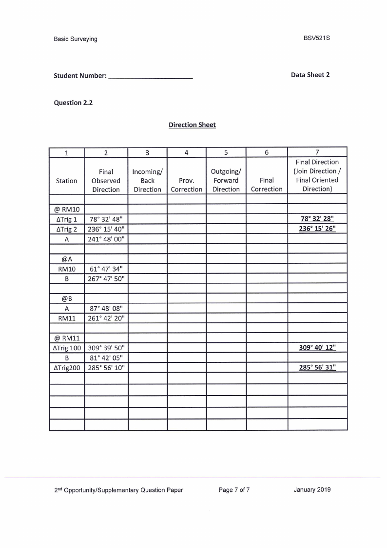
Data Sheet 2
Question 2.2
Direction Sheet
Final
Observed
Direction
Incoming/
Back
Direction
Prov.
Correction
Outgoing/
Forward
Direction
Final
Correction
7
Final Direction
(Join Direction/
Final Oriented
Direction)
@ RM10
ATrig 1 78° 32' 48"
ATrig 2 | 236° 15' 40"
A
241° 48' 00"
78° 32' 28"
15' 26"
@A
61° 47' 34"
267° 47' 50"
@B
A
RM11
87° 48' 08"
| 261° 42' 20"
@ RM11
ATrig 100 | 309° 39' 50"
B
81° 42' 05"
ATrig200 | 285° 56' 10"
309° 40'
° 56'
4"
24 Opportunity/Supplementary Question Paper
Page 7 of 7
January 2019