


 |
GES512S - GEOGRAPHIC INFORMATION SYSTEMS 1 - 1ST OPP - JUNE 2023 |
|
|
1 Page 1 |
▲back to top |
nAmtBIA untVERSITY
OF SCIEnCE Ano TECHnOLOGY
FACULTY OF ENGINEERING AND THE BUILT ENVIRONMENT
DEPARTMENT OF LAND AND SPATIALSCIENCES
QUALIFICATION: BACHELOR OF NATURAL RESOURCE MANAGEMENT, BACHELOR OF NATURAL
RESOURCE MANAGEMENT IN NATURE CONSERVATION, ADMINISTRATION, BACHELOR OF LAND
ADMINISTRATION, BACHELOR OF TOWN AND REGIONAL PLANNING, BACHELOR OF PROPERTY
STUDIES, DIPLOMA IN PROPERTYSTUDIES, BACHELOR OF REGIONAL & RURAL DEVELOPMENT
QUALIFICATION CODE: 07BNRS,
LEVEL: 5
07BNTC, 06DLAD, 07BLAM, 07BTAR,
06DPRS,08BPRS,07BRAR
COURSECODE: GES512S
COURSENAME: GEOGRAPHIC INFORMATION
SYSTEMS 1
DATE: JUNE 2023
SESSION: 1
DURATION: 3 HOURS
MARKS: 100
FIRST OPPORTUNITY EXAMINATION QUESTION PAPER
EXAMINER:
MS ROXANNEMURANGI
MODERATOR: MR MIGUEL VALLEJO
INSTRUCTIONS
1. Write your student number on the answer sheet used.
2. Answer ALL the questions.
3. Read each question carefully before attempting to answer.
4. Write clearly and neatly.
1. Ruler
2. Pen
3. Pencil
4. Eraser
MATERIALS PERMISSIBLE
This paper consists of four (4) pages (excluding this cover page)
|
|
2 Page 2 |
▲back to top |
Geographic Information Systems 1
Question 1
Define the following terms in the GIScontext:
1.1. Geographic phenomena
1.2. Datum
1.3. Ellipsoid
1.4. Map scale
1.5. Attribute table
GES512S
(2)
(2)
(2)
(2)
(2)
1101
Question 2
2.1. In your own words, discuss the term geographic information. Provide examples and
applications in which each of the mentioned examples may be used. Provide at least
five (5) examples.
(6)
2.2. We study geographic phenomena because we want to gain a better understanding of
our environment (geographic space) and events occurring there (de By 2004). In your
own words, discuss what a GISis.
(3)
2.3. A GIS constitutes of five key components: hardware, software, data, people and
methods and standards. Discussthe component data and three stages of working with
GIS data.
(8)
2.4. Describe how GISsoftware is different from other computer software.
(4)
First Opportunity Exam Question Paper
Page 2 of 5
June 2023
|
|
3 Page 3 |
▲back to top |
Geographic Information Systems 1
GES512S
2.5. There are five types of questions that a sophisticated GIS can answer. Briefly discuss
the questions what if (modelling)? and what is at? and provide one example for each
question.
(4)
[25]
Question 3
3.1. Differentiate between a feature, feature class and feature dataset.
(6)
3.2. Explain what a GIS layer is. Outline any five additional GIS principles.
(6)
3.3. What is a horizontal datum? Provide two uses of a horizontal datum.
(4)
3.4. Describe the UTM coordinate system. What type of developable surface is used for a
UTM projection?
(3)
3.5. What are the UTM zones, and where is the zone of origin?
(3)
3.6. How are negative coordinates avoided in a UTM coordinate system?
(3)
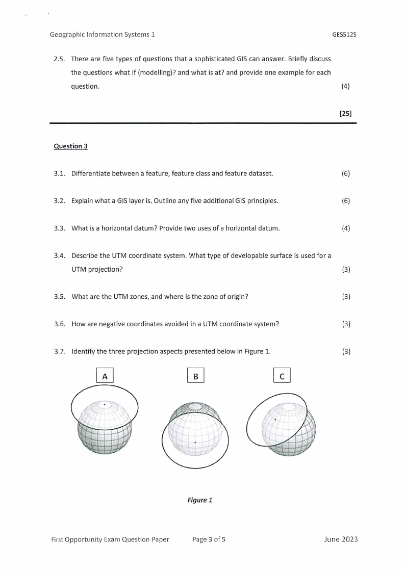
3.7. Identify the three projection aspects presented below in Figure 1.
(3)
Figure 1
First Opportunity Exam Question Paper
Page 3 of 5
June 2023
|
|
4 Page 4 |
▲back to top |
Geographic Information Systems 1
GES512S
3.8. Explain what conformal projection is. Provide two useful applications of a conformal
projection.
(4)
[32]
Question 4
4.1. A variety of methods exist for creating vector data including digitizing, GPS data
collection, geocoding, and scanning. Briefly discuss the digitizing technique and outline
two problems of paper map digitization.
(4)
4.2. A raster data model uses a matrix of pixels or cells arranged in rows and columns to
represent continuous phenomena. The accuracy of a raster depends on scale and
resolution. Briefly explain the term resolution.
(1)
4.3. List the three methods of raster data creation.
(3)
4.4. State why elevation is considered a continuous phenomenon.
(2)
[10]
First Opportunity Exam Question Paper
Page4 of 5
June 2023
|
|
5 Page 5 |
▲back to top |
Geographic Information Systems 1
Question 5
GES512S
5.1. Briefly explain the term spatial analysis. Provide four spatial analytical functions.
(5)
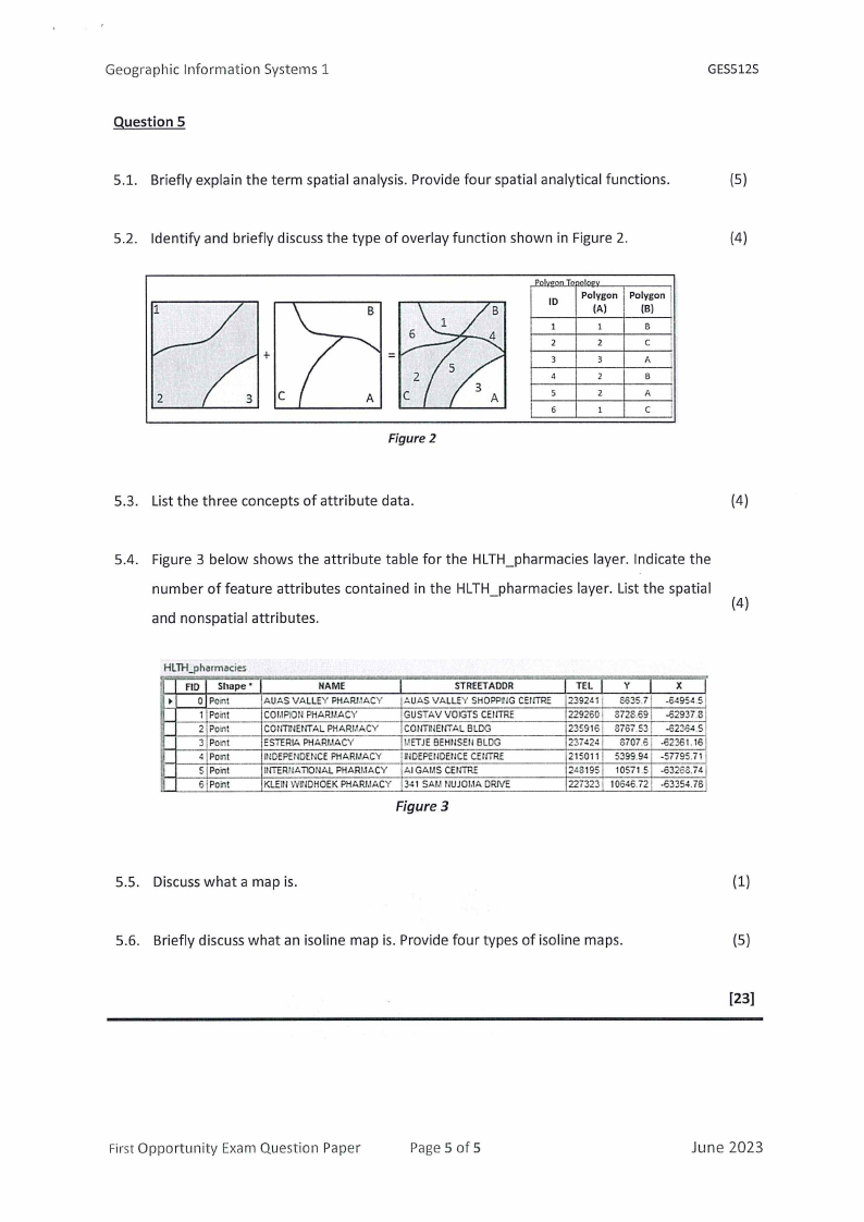
5.2. Identify and briefly discuss the type of overlay function shown in Figure 2.
(4)
+
=
2
C
Figure 2
ID
Polygon Polygon
(A)
(Bl
B
2
C
3
A
4
B
s
2
A
6
C
5.3. List the three concepts of attribute data.
(4)
5.4. Figure 3 below shows the attribute table for the HLTH_pharmacies layer. Indicate the
number of feature attributes contained in the HLTH_pharmacies layer. List the spatial
(4)
and nonspatial attributes.
HLTH-pharmacies
FID Shape•
0 Point
1 Point
2 Point
3 Point
41Point
5 Point
6 Point
NAME
AUAS VALLEY PHARJ,IACY
COI.IPlON PHARMACY
CONTINEtffAL PHARl.!ACY
ESTERJt, PHARl,IACY
INDEPENDENCEPHARl,IACY
lt·ITTRIIATIONAL PHARJ,IACY
KLEIN WUlDHOEK PHARJ,1ACY
STREETADDR
AUAS VALLEY SHOPPillG CEl!TRE
GUSTAVVOIGTS CEHTRE
COl·ITTlENTAL BLDG
J,IETJEBEHllSEll BLDG
UlDEPEIJOEtJCECWTRE
Al GAi.iS CENTRE
341 SAl,1 tlUJOl,IA DRIVE
Figure 3
TEL
239241
229260!
235916
237424
215011
2~8195
227323
y
8635.7
8726.69
8767.53
6707.6
5399.94
10571.5
10646.72
X
-64954.5
-62937.8
-<i2364.5
-62361.16
-57795.71
-<i32o8.74
-63354.78
5.5. Discusswhat a map is.
(1)
5.6. Briefly discuss what an isoline map is. Provide four types of isoline maps.
(5)
[23]
First Opportunity Exam Question Paper
Page5 of 5
June 2023