


 |
GES512S - GEOGRAPHIC INFORMATION SYSTEMS 1 - 2ND OPP - JULY 2023 |
|
|
1 Page 1 |
▲back to top |
nAmlBIA UnlVERSITY
OF SCIEnCE Ano TECHnOLOGY
FACULTY OF ENGINEERING AND THE BUILT ENVIRONMENT
DEPARTMENT OF LAND AND SPATIAL SCIENCES
QUALIFICATION: BACHELOR OF NATURAL RESOURCE MANAGEMENT, BACHELOR OF NATURAL
RESOURCE MANAGEMENT IN NATURE CONSERVATION, ADMINISTRATION, BACHELOR OF LAND
ADMINISTRATION, BACHELOR OF TOWN AND REGIONAL PLANNING, BACHELOR OF PROPERTY
STUDIES, DIPLOMA IN PROPERTYSTUDIES, BACHELOR OF REGIONAL & RURAL DEVELOPMENT
QUALIFICATION CODE: 07BNRS,07BNTC, LEVEL: 5
06DLAD, 07BLAM, 07BTAR, 06DPRS,
08BPRS, 07BRAR
COURSE CODE: GES512S
COURSE NAME: GEOGRAPHIC INFORMATION
SYSTEMS 1
DATE: JULY 2023
SESSION: 1
DURATION: 3 HOURS
MARKS: 100
SECOND OPPORTUNITY/ SUPPLEMENTARY EXAMINATION QUESTION PAPER
EXAMINER:
MS ROXANNEMURANGI
MODERATOR: MR MIGUEL VALLEJO
INSTRUCTIONS
1. Write your student number on each answer sheet used.
2. Answer ALL the questions.
3. Read each question carefully before attempting to answer.
4. Write clearly and neatly.
1. Ruler
2. Pen
3. Pencil
4. Eraser
MATERIALS PERMISSIBLE
This paper consists of four (4) pages (excluding this cover page
|
|
2 Page 2 |
▲back to top |
J
Geographic Information Systems 1
Question 1
Define the following terms in the GIScontext:
1.1. Map projection
1.2. Geo-referencing
1.3. Database
1.4. Map scale
1.5. Geographic analysis
1.6. Polygon overlay
1.7. Intersect
GES512S
(2)
(2)
(2)
(2)
(2)
(2)
(2)
{14}
Question 2
2.1. Define the term geographic phenomena. List the three key elements that define a
geographic phenomenon.
(5)
2.2. Explain hardware and people as components of GIS.
(4)
2.3. Outline two main advantages that GIS has over other types of information systems.
(3)
2.4. The four functions of GISare data entry, data storage and maintenance, spatial analysis
and manipulation, and data visualization. Briefly discuss data storage and
maintenance, as well as data analysis and manipulation.
(4)
Second Opportunity/ Supplementary Exam Question Paper
Page 2 of 5
[16]
July 2023
|
|
3 Page 3 |
▲back to top |
)
Geographic Information Systems 1
Question 3
GES512S
3.1. Explain what a coordinate system is. Provide the two main elements of a coordinate
system.
(3)
3.2. What is the main practical importance of a coordinate system?
(2)
3.3. Briefly explain what map projection is.
(2)
3.4. Map projections are categorized according to four characteristics. Name any three
characteristics.
(3)
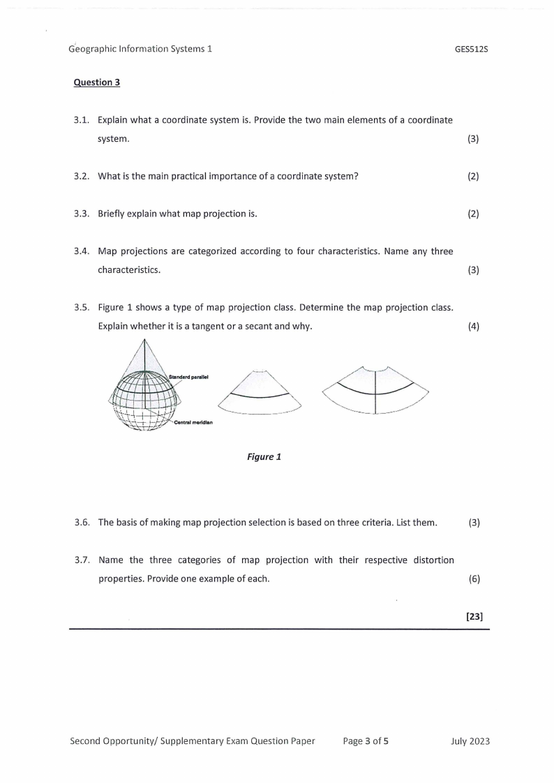
3.5. Figure 1 shows a type of map projection class. Determine the map projection class.
Explain whether it is a tangent or a secant and why.
(4)
Figure 1
3.6. The basis of making map projection selection is based on three criteria. List them.
(3)
3.7. Name the three categories of map projection with their respective distortion
properties. Provide one example of each.
(6)
[23]
Second Opportunity/ Supplementary Exam Question Paper
Page 3 of 5
July 2023
|
|
4 Page 4 |
▲back to top |
Geographic Information Systems 1
Question 4
GES512S
4.1. Name and briefly explain each of the three functions you can perform to understand
data characteristics in GIS.
(6)
4.2. Discuss how the vector data model differs from the raster data model in representing
spatial features. Provide an appropriate example of what each can represent.
(4)
4.3. Explain the raster data model as a means of representing GISdata.
(4)
4.4. Explain the concept of utilising counts and cell values within a raster data model.
(4)
4.5. Name four methods of vector data creation.
(4)
[22]
Question 5
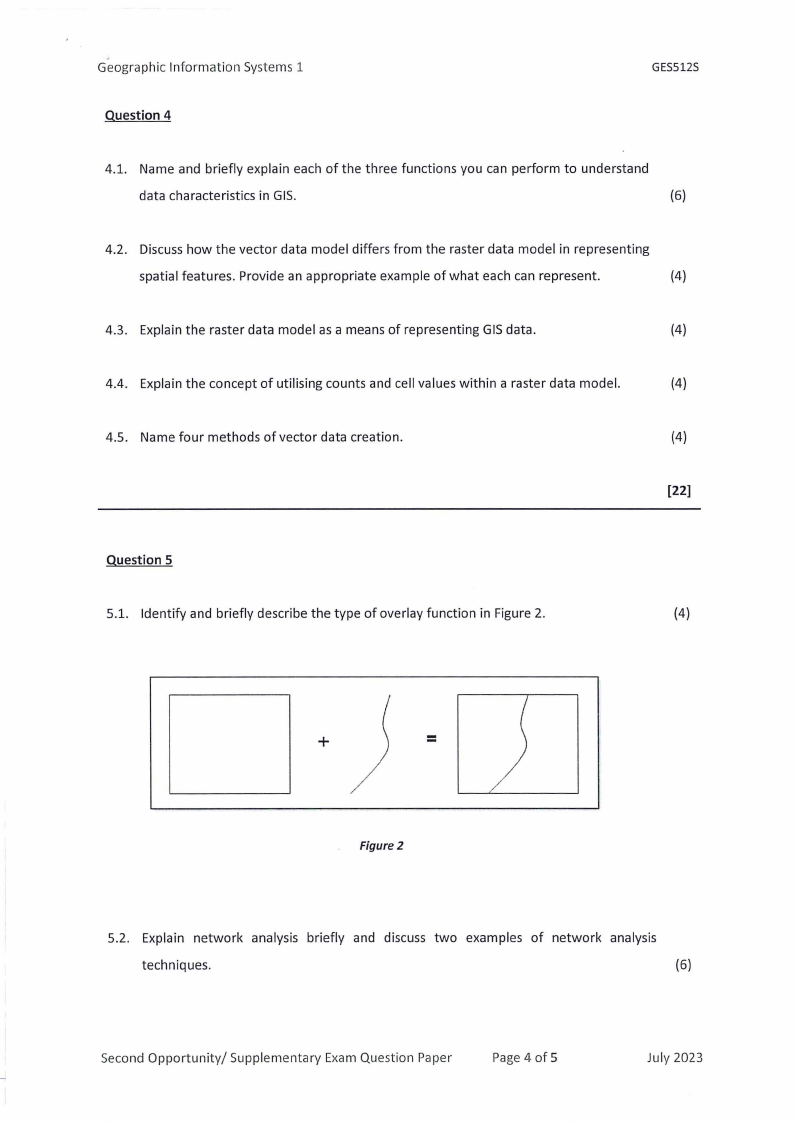
5.1. Identify and briefly describe the type of overlay function in Figure 2.
(4)
+
=
Figure 2
5.2. Explain network analysis briefly and discuss two examples of network analysis
techniques.
(6)
Second Opportunity/ Supplementary Exam Question Paper
Page4 of 5
July 2023
|
|
5 Page 5 |
▲back to top |
Geographic Information Systems 1
GES512S
5.3. Explain the selection by attribute query and what type of question does it answer?
(3)
5.4. Briefly discuss what a chorochromatic map is. Provide two examples of chorochromatic
maps.
(3)
5.5. Name four (4) rules that must be followed to classify quantitative data.
(4)
5.6. Classification decisions are influenced by five factors. What are these factors?
(5)
[25]
Second Opportunity/ Supplementary Exam Question Paper
Page 5 of 5
July 2023