


 |
GES512S - GEOGRAPHIC INFORMATION SYSTEMS 1 - 1ST OPP - JUNE 2025 |
|
|
1 Page 1 |
▲back to top |
n Am I BIA u n IVER s ITY
OF SCIEnCE Ano TECHnOLOGY
FACULTY OF ENGINEERING AND THE BUILT ENVIRONMENT
DEPARTMENT OF LAND AND SPATIALSCIENCES
QUALIFICATIONS:
BACHELOROF NATURALRESOURCEMANAGEMENT IN NATURECONSERVATION
BACHELOROF NATURALRESOURCEMANAGEMENT
QUALIFICATION CODES:
07BNTC
07BNRS
COURSECODE:GES512S
LEVEL:
Level7-07BNT~07BNRS
COURSENAME: GEOGRAPHICINFORMATION
SYSTEMS1
SESSION:JUNE2025
PAPER:THEORY
DURATION: 3 HOURS
MARKS: 100
FIRSTOPPORTUNITYEXAMINATION QUESTION PAPER
EXAMINER: Ms Roxanne Murangi
MODERATOR: Mr Erich Naoseb
INSTRUCTIONS
1. Write your student number and programme code on the answer sheet.
2. Answer ALLthe questions.
3. Read each question carefully before attempting to answer.
4. Write clearly and neatly.
1. Pen
2. Pencil
3. Eraser
4. Ruler
PERMISSIBLEMATERIALS
This question paper consistsof six (6) pages,includingthis cover page.
|
|
2 Page 2 |
▲back to top |
GPogr.:iphic lnfonnJtion Sy',\\P111s1
Question 1
(,E'SLJS
Answer the multiple-choice questions listed below. Pleaseselect the ONE most relevant to
the following questions. Indicate the correct answer on the answer sheet.
1.1. Data that describe the characteristics of spatial features.
(1)
A. Attribute data
B. Ancillary data
C. Auxiliary data
D. Associative data
1.2. A systematic arrangement of parallels and meridians on a plane surface.
(1)
A. Meridians
B. Equator
C. Surface
D. Map projection
1.3. What is the purpose of the "Select by Location" tool in GIS?
(1)
A. To choose features based on their attribute values
B. To pick features based on their spatial relationship to other features
C. To select features randomly for sampling
D. To identify features with incomplete attribute data
1.4. The following are the major ways to represent the world or geographic phenomena
in QGIS,except.
(1)
A. Features (collection of lines, points, and polygons)
B. Attributes (associated features)
C. Spreadsheet without coordinates attached to the data
D. Remotely sensed data or imagery
First Opportunity Question Paper
Page 2 of 6
Jw1e 2025
|
|
3 Page 3 |
▲back to top |
Geographic lnformalion Sy~;tems1
1.5. Which of the following are examples of common map elements?
(1)
A. Label, variables, and symbols
B. Database, theme, distortion lines
C. Inset, scale, frame, and legend
D. Points, lines, and polygons
[5]
Question 2
2.1. In your own words, briefly discuss what GISis. List the three (3) major components of
a GIS.
(7)
2.2. Briefly describe what Geospatial data is. Provide any three (3) examples of geospatial
data.
(4)
2.3. A GIS has four (4) functions. Briefly discuss any two functions and provide two
examples for each.
(4)
2.4. A city intends to build a new hospital. How can GIS assist them in selecting the ideal
location? Provide at least five (4) spatial datasets that will be used to determine the
optimal site for the new hospital.
(4)
2.5. Identify the labelled parts of Figure 1 extracted from ArcCatalog below and briefly
explain the purpose of the parts identified.
(6)
fir<;t Opportunity Queslion Paper
Page 3 of 6
June 2025
|
|
4 Page 4 |
▲back to top |
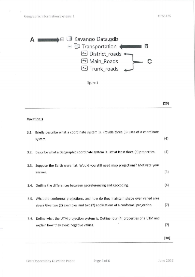
C,Pographiclnf-onnation Syslems 'I
Gl:S'..ilA
A
8 LJ KavangoData.gdb
J- 8 G:PTransportation
B
8 District_roads
Main_Roads
C
8 Trunk_roads
Figure 1
[25]
Question 3
3.1. Briefly describe what a coordinate system is. Provide three {3) uses of a coordinate
system.
(4)
3.2. Describe what a Geographic coordinate system is. List at least three (3) properties.
(4)
3.3. Suppose the Earth were flat. Would you still need map projections? Motivate your
answer.
(4)
3.4. Outline the differences between georeferencing and geocoding.
(4)
3.5. What are conformal projections, and how do they maintain shape over varied area
sizes?Give two (2) examples and two (2) applications of a conformal projection.
(7)
3.6. Define what the UTM projection system is. Outline four (4) properties of a UTM and
explain how they avoid negative values.
(7)
[30]
First Opportunity Question Paper
Pc1ge4 of 6
June 2025
|
|
5 Page 5 |
▲back to top |
G~:ographiclnfonmnion Sy\\lPrns.J
Question 4
4.1. Briefly describe the difference between thematic rasters and image rasters.
c,r:ss12.s
(4)
4.2. A wildlife conservation team is tasked with mapping and monitoring the migration
patterns of endangered animals across Etosha National Park. They plan to use GISto
create detailed maps that show migration routes, the locations of watering holes, and
protected areas to better manage the park's resources and improve conservation
efforts.
a) What vector data collection methods would suit a wildlife conservation project?
Provide at least one (1) example of the vector data types (points, lines, or
polygons) that could be collected using each method to support this conservation
effort.
(6)
4.3. Name and briefly describe any three (3) functions you can perform to understand the
data characteristics in GIS.
(6)
4.4. Describe how the raster data model represents GISdata.
(4)
(20)
Question 5
5.1. Outline and describe the three (3) concepts of attributes.
(6)
5.2. Explain the Selection by Location Query works. List three (3) possible options that you
can use in a Selection by Location Query.
(4)
5.3. What do the main classification decisions refer to during the map production?
(3)
5.4. Write a valid SQL expression to select 11Cities11 with people between 1800 and 3000
using a field called POP2000 from the Citizens layer.
(3)
First Opportunity Question Paper
Page 5 of 6
June 202'.J
|
|
6 Page 6 |
▲back to top |
Cieogr;:iphiclnfon,1c1tio11'-iysiems 1
S.S. Indicate what each of the following terms are used to represent:
a) Contours
(1)
b) Isotherms
{1)
c) lsobaths
{1)
d) lsochrones
(1)
(20)
Fir~t Opporl1111ity Question Paper
Page 6 of6
June 2025