


 |
GES512S - GEOGRAPHIC INFORMATION SYSTEMS 1 - 2ND OPP - JULY 2025 |
|
|
1 Page 1 |
▲back to top |
nAmlBIA un1VERSITY
OF SCIEnCE Ano TECHnOLOGY
FACULTY OF ENGINEERING AND THE BUILT ENVIRONMENT
DEPARTMENT OF LAND AND SPATIALSCIENCES
QUALIFICATIONS:
BACHELOROF NATURALRESOURCEMANAGEMENT IN NATURECONSERVATION
BACHELOROF NATURALRESOURCEMANAGEMENT
QUALIFICATION CODES:
07BNTC
07BNRS
COURSECODE:GES512S
LEVEL:
Level 7 - 07BNTC,07BNRS
COURSENAME: GEOGRAPHICINFORMATION
SYSTEMS1
SESSION:JULY2025
PAPER:THEORY
DURATION: 3 HOURS
MARKS: 100
SECOND OPPORTUNITY/SUPPLEMENTARY EXAMINATION QUESTION PAPER
EXAMINER:
Ms Roxanne Murangi
MODERATOR: Mr Erich Naoseb
INSTRUCTIONS
1. Write your student number and programme code on the answer sheet.
2. Answer ALLthe questions.
3. Read each question carefully before attempting to answer.
4. Write clearly and neatly.
1. Pen
2. Pencil
3. Eraser
4. Ruler
PERMISSIBLEMATERIALS
This paper consists of five (5) pages (including this cover page).
|
|
2 Page 2 |
▲back to top |
Geographic lnformr1tio11Syste1n<:;I
Question 1
Answer the multiple-choice questions listed below. Please select the ONE most relevant to
the following questions. Indicate the correct answer on the answer sheet.
1.1. How does GIS enhance decision-making processes?
(1)
A. By providing real-time data only
B. By enabling spatial analysis and visualisation of data
C. By limiting accessto data
D. By focusing solely on historical data
1.2. What is the primary function of a Geographic Information System (GIS)?
(1)
A. To manage information related to features on the Earth's surface
B. To manage human resources data
C. To manage general information within an organisation
D. To manage financial data
1.3. What is the purpose of the "Select by Location" tool in GIS?
(1)
A. To choose features based on their attribute values
B. To choose features based on their spatial relationship to other features
C. To select features randomly for sampling
D. To identify features with complete attribute data
1.4. Which type of map projection is most suitable for mapping regions or hemispheres,
but is seldom used for mapping the entire world?
(1)
A. Equivalent Map Projection
B. Azimuthal Map Projection
C. Cylindrical Map Projection
D. Conical Map Projection
Second Opportunity/Supplementary Question Paper Page 2 of 5
July 2025
|
|
3 Page 3 |
▲back to top |
Geographic lnforrn,1tion '.:>ysterns1
(~f:SS'l:/.S
1.5. Which of the following represents the correct set of coordinate classifications in GIS? (1)
A. Geographic, geometric systems
B. Geographic, projected systems
C. Spherical, projected systems
D. Geographic, spherical systems
[5]
Question 2
2.1. Outline the differences between data and information. Provide two (2) examples for
each.
(6)
2.2. A GIS can play a very useful role for local governments. Local Governments are
responsible for planning and delivering services to citizens. You are tasked with
implementing a GISfor the Bethanie Town Council. Your first task is to convince the
Bethanie Town Council that GIS is an ideal tool for planning and decision-making.
Write a short memo to the Council explaining:
a) What a GIS is.
(4)
b) What can GIS do for local government planning?
(4)
c) The advantages of using GIS instead of traditional paper maps and manual
analysis. Outline at least four (4) benefits.
(4)
2.3. Briefly describe the term Geographic phenomena and outline the three (3)
characteristics of geographic phenomena. Outline and explain the two (2) forms to
categorise them. Provide two examples for each of the two forms.
(12)
2.4. Name and describe the two (2) types of GIS concepts. Provide one (1) example for
each concept.
(6)
Secolld Opportunity/Supplementary Question Paper Page 3 of 5
July 2025
|
|
4 Page 4 |
▲back to top |
C:ieogrc1phiclnfonna1 iun Systems 1
2.5. How does a GIS software (e.g., QGISfor Desktop) differ from Google Maps?
GFSS l25
(4)
(40)
Question 3
3.1. What are the three (3) most important factors to consider when choosing a map
projection?
(3)
3.2. Briefly outline the differences between geographic and projected coordinate systems.. (8)
3.3. You are planning a hiking trip to the Fish River Canyon. You have a map that shows
the trail distances and elevations.
a) What is a datum, and why is it important for this map?
(4)
b} What are the two main types of datums, and how do they differ?
(4)
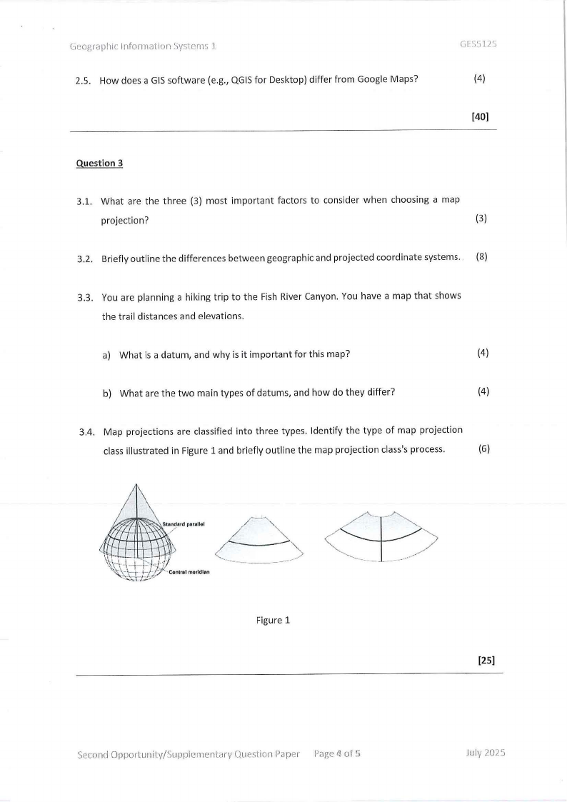
3.4. Map projections are classified into three types. Identify the type of map projection
class illustrated in Figure 1 and briefly outline the map projection class's process.
(6)
_______.,-
.......
Figure 1
Second Opportunity/Supplementary Question Paper P;:ige4 of 5
[25)
July 2025
|
|
5 Page 5 |
▲back to top |
Gf'ographic Information Syslems ·1
Question 4
GLS511'i
4.1. Vector overlay can be done in different forms. List and briefly explain the vector-based
overlays.
(6)
4.2. Assume you need a map of all the primary schools in the Kavango region. You
downloaded a shapefile called schools from the Digital Namibia website, which shows
all the schools in Namibia. What GIS operation (s) will you apply on the school layer
to retrieve only the primary schools in the Kavango region? Motivate your answer.
(4)
4.3. Describe buffering in geographic information systems (GIS). Provide three (3) distinct
examples of how buffering can be applied in spatial analysis.
(4)
4.4. Differentiate between spatial attributes and non-spatial attributes.
(4)
4.5. Outline any three (3) factors that will influence the map's scale selection.
(3)
4.6. List and describe the three (3) different types of thematic maps. Provide two (2)
examples of each, as well as the data type that was used to display the data.
(9)
(30)
Second Opportunity/Supplementary Question Paper Page 5 of S
July 2025