


 |
TGE510S - TOURISM GEOGRAPHY - 1ST OPP - JUNE 2025 |
|
|
1 Page 1 |
▲back to top |

n Am I BI A u n IVE RSITY
OF SCIEnCE Ano TECHnOLOGY
FACULTY OF COMMERCE, HUMAN SCIENCES AND EDUCATION
DEPARTMENT OF HOSPITALITY AND TOURISM
QUALIFICATION: BACHELORSDEGREEIN TOURISM; INNOVATION AND DEVELOPMENT
QUALIFICATION CODE: 07BTID MODE: FM
COURSE CODE: TGE510S
COURSE NAME: TOURISM GEOGRAPHY
SESSION: JUNE 2025
DURATION: 2 HOURS
PAPER:1
MARKS: 100
EXAMINER:
15T OPPORTUNITY EXAMINATION QUESTION PAPER
Ms. U. Tjitunga
MODERATOR: Ms. E. Kuwa
INSTRUCTIONS
1. Answer ALLthe questions and start each question on a new page.
2. Read all questions carefully before answering.
3. Number answers according to the numbering structure provided in the question
paper.
THIS QUESTION PAPER CONSISTS OF 4 PAGES (Including this front page)
|
|
2 Page 2 |
▲back to top |
Question 1
(10x2=20)
Write one correct answer
1.1The line on the exact opposite of the Prime Meridian.
1.2 As you travel from west to east, does it get later or earlier?
1.3 How many time zones are there in the world?
1.4 A _______
is exactly half of the earth.
1.5 The invisible line at O degrees latitude is called the ___ _
1.6 What shape is the planet Earth?
1.7 The equator breaks the Earth into what two hemispheres?
1.8 Antarctica, Australia, and most of South America are in what hemisphere?
1.9 The Tropic of _____
is a line of latitude that runs through North America, the
northern point of Africa, and Asia.
1.10 In which hemisphere would the Antarctic Circle be found?
Question 2
(Sx3=15)
Climate is the long-term condition of a particular region. The climate changes in a particular
region are based on the atmosphere and environmental conditions of that region. Identify
and describe the factors that affect the climate of a place.
Question 3
(Sx2=10)
There are several key elements that should be included each time a map is created in order
to aid the viewer in understanding the communications of that map and to document the
source of the geographic information used. Describe the different elements of a map.
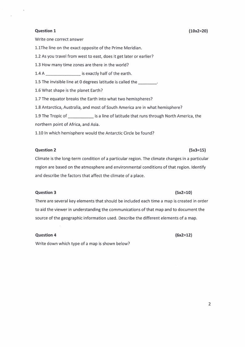
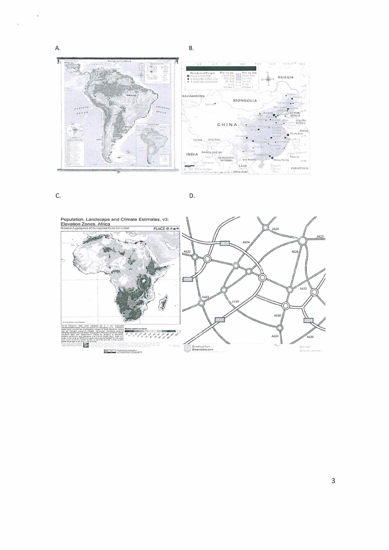
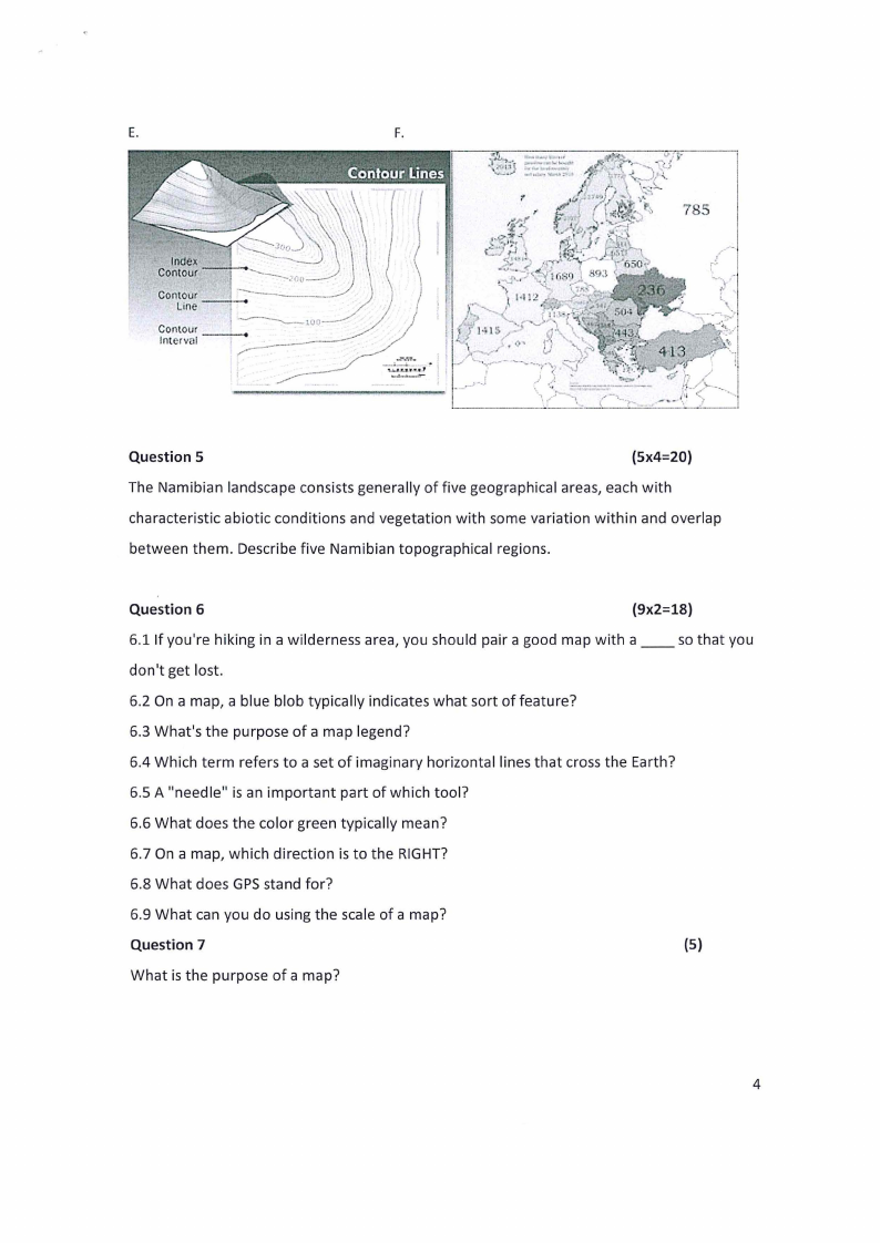
Question 4
Write down which type of a map is shown below?
(6x2=12)
2
|
|
3 Page 3 |
▲back to top |
A.
B.
11,,.,,1,.,, ol !),.u,ilo
or,.,,rl!0,1,l,N•1
• •l r,V~.\\'QI.\\.~; O('(l_ll~l;)
• t ,,1,.i.r,:.,.,1. ,-,._.n,ocu
IKAZJ\\KltSl'AN
r- . ..,.,..,..
t
CH IN A
UHifTAN
. . .. :,),.,,,, In"•
'
f'U'
\\
• 11,,1,a.,;
, TJOfrn1
r •• •• • •u,-~!_>nc.,
..
<J<
Sovm
t•'•l(()r.[i",
.sh,,,,.,1;~~"~r,
I ~II .! I
. ,.· ,· INOIA
r.t1
• 1 ~., •, f,lYl•iJr,1/,1:
,
1uu11,.1r,i /· v1cnu,,,
I0
.' ,I
' '·'"· ••
....
1
,
Lt,QS
'~•~-,..'.~•~-•-t~;•t•~•.•-~,.,•,
•,1
,
"IHf,t~~~-,~
1,,..,. ,..,1; •.
r" ·••11u,,ul\\u,.'u1'""·"'
.., :·•, •1.
•:,
;"tlllli'Pl."J(S
C.
D.
Population, Landscape and Climate Estimates, v3:
Elevation Zones Africa
;,~i-:~'.'~:~~~"j~;<~'-~:.';--.~-?fw.~J ;;;.~~:?.
._..,._..~..·-·l:r:!·.·.,... ..
~-------·.-;;-.
L,.
(
3
|
|
4 Page 4 |
▲back to top |
E.
F.
..•l.,,._. :::. ....,.-..~. · ,.,
•(•~Jl-i[ . .-..,..._J •
..__J ... ·--~~ ,
~rt-.'(,
·~,
U':-;-·
l.'•j
n·,J )/'\\.
t
785
..., .
.t>-',~\\l•I-
'/ l·Hf> _,_:.·• •
.,,
~~~---.
.-,· ._ -.----
'!......,._.1_._.£_.S_._•~,,'."..'
.1'
- _,._J .
V
....-....,___;,_"io--,~,:,,
))
. '.,
---:--:=--~-,---
'._I('.J--..._""l,- { .._. r--.J--
•
.,I--~,(/ ~---\\.-
- '.,li
Question 5
(5x4=20)
The Namibian landscape consists generally of five geographical areas, each with
characteristic abiotic conditions and vegetation with some variation within and overlap
between them. Describe five Namibian topographical regions.
Question 6
(9x2=18)
6.1 If you're hiking in a wilderness area, you should pair a good map with a __ so that you
don't get lost.
6.2 On a map, a blue blob typically indicates what sort of feature?
6.3 What's the purpose of a map legend?
6.4 Which term refers to a set of imaginary horizontal lines that cross the Earth?
6.5 A "needle" is an important part of which tool?
6.6 What does the color green typically mean?
6.7 On a map, which direction is to the RIGHT?
6.8 What does GPSstand for?
6.9 What can you do using the scale of a map?
Question 7
(5)
What is the purpose of a map?
4