


 |
IGD411S - INTRODUCTION TO GEOSPATIAL DATA - 1ST OPP - JUNE 2023 |
|
|
1 Page 1 |
▲back to top |
nAm I BI A un IVERSITY
OF SCIEnCE Ano TECHn OLOGY
FACULTY OF ENGINEERING AND THE BUILT ENVIRONMENT
DEPARTMENTOF LANDAND SPATIALSCIENCES
QUALIFICATION: BACHELOROF NATURAL RESOURCEMANAGEMENT (NATURE CONSERVATION),
BACHELOR OF GEOINFORMATION TECHNOLOGY, BACHELOR OF LAND ADMINISTRATION, BACHELOR OF
PROPERTY STUDIES HONOURS, BACHELOR OF REGIONAL AND RURAL DEVELOPMENT, BACHELOR OF
TOWN AND REGIONAL PLANNING, DIPLOMA IN PROPERTYSTUDIES
QUALIFICATION CODE: 07BNRS, 07BGEI,
07BLAM, 08BPRS, 08BOPS, 07BRAR, LEVEL:4
07BTAR, 06DIPS, 06DPRS
COURSE: INTRODUCTION TO
GEOSPATIAL DATA
COURSECODE: IGD411S
SESSION: JUNE 2023
PAPER:
THEORY
DURATION: 2 HOURS
MARKS:
80
FIRSTOPPORTUNITYEXAMINATION QUESTION PAPER
EXAMINER: Ms D. Husselmann
MODERATOR: Mr E. Naoseb
THIS QUESTION PAPERCONSISTSOF 5 PAGES(Including this front page)
INSTRUCTIONS
1. Answer ALL the questions.
2. Write clearly and neatly.
3. Number the answers clearly.
4. Answers to calculations must be rounded off to three decimal places, excluding
answers to co-ordinate conversions
PERMISSIBLEMATERIALS
1. Examination paper.
2. Examination script.
3. Calculators and other drawing equipment.
|
|
2 Page 2 |
▲back to top |
Introduction to Geospatial Data
Question 1
1.1. What do the following acronyms stand for?
IGD4115
(5)
a. MSL
b. TIN
c. DTM
d. UTM
e. GPS
1.2. State whether the following is True or False.
(5)
a. Topographic maps are reference maps that mostly contain height information like
contour lines and spot heights.
b. A spatial point is defined by an exact location in space. It has volume, area and length.
c. A camera is a remote sensing device.
d. Having a smaller scale, allows more detail to be shown on maps.
e. The more satellites visible to a GPSreceiver, the more accurate the determined position
becomes.
(10)
Question 2
2.1. Draw two pictures displaying how a point will be displayed using
(2)
a. a vector data model and
b. a raster data model
2.2. What type of co-ordinates are used to show horizontal position for each of the following co-
ordinate systems?
(4)
a. Geographic co-ordinate system
b. Projected co-ordinate system
First Opportunity Question Paper
Page 2 of 5
June 2023
|
|
3 Page 3 |
▲back to top |
Introduction to Geospatial Data
2.3. Does the earth have a regular shape? Yes/ No
2.4. Calculate the straight-line distance from 10° 56' 20" Eto 38° 47' 29" Eat 71° 58' 39" S.
IGD411S
(1)
(4)
(11)
Question 3
3.1. The following points represent vertices on Erf number 205, Orwetoveni, Otjozondjupa
Region. Calculate the area of the erf.
(8)
Point
y
X
A
-8670.380
-62120.790
B
-8674.620
-62145.930
C
-8724.030
-62136.460
D
-8723.740
-62131.320
E
-8703.540
-62134.900
3.3. Convert the following geographical coordinates into degrees, minutes and seconds.
(6)
a. 22.639°S
17.963°E
b. 23.542°S
18.275°E
3.4. A tower is 2 km due north of a church. A windmill is 5 km east of the tower. A map is to be
drawn with a scale of 1: 25 000. What will be the distance on the map between the church
and the tower?
(3)
To::iwer•
[17)
Question 4
4.1 List five map elements.
(5)
4.2 List two differences between small scale maps and large scale maps.
(4)
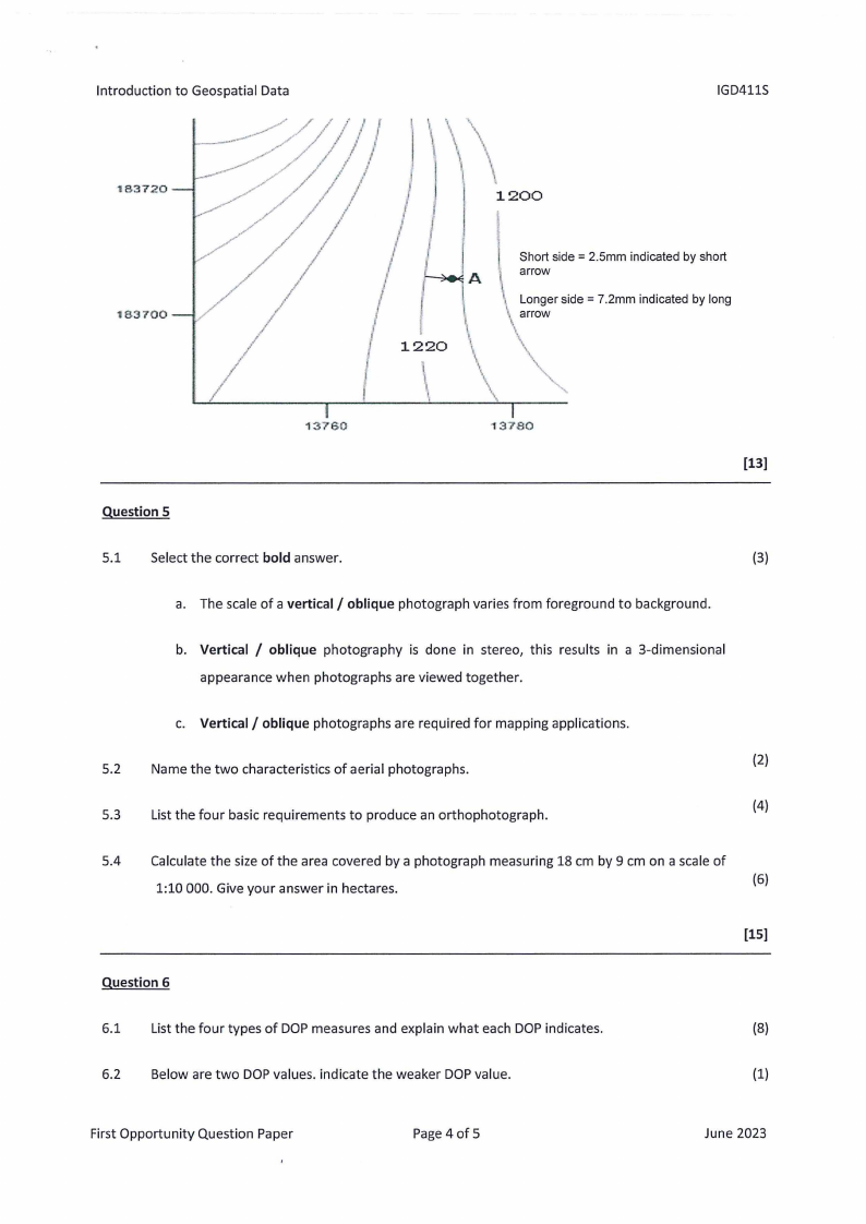
4.3 The following is part of a contour map of a planned recreational facility in Otjomuise,
Windhoek. Estimate the elevation of point A.
(4)
First Opportunity Question Paper
Page 3 of 5
June 2023
|
|
4 Page 4 |
▲back to top |
Introduction to Geospatial Data
IGD411S
183720
183700
13760
1200
1220
Short side = 2.5mm indicated by short
A l arrow
\\ Longer side= 7.2mm indicated by long
arrow
\\
\\\\
\\
\\
...
13780
Question 5
5.1 Select the correct bold answer.
(3)
a. The scale of a vertical/ oblique photograph varies from foreground to background.
b. Vertical / oblique photography is done in stereo, this results in a 3-dimensional
appearance when photographs are viewed together.
c. Vertical/ oblique photographs are required for mapping applications.
5.2 Name the two characteristics of aerial photographs.
(2)
5.3 List the four basic requirements to produce an orthophotograph.
(4)
5.4 Calculate the size of the area covered by a photograph measuring 18 cm by 9 cm on a scale of
1:10 000. Give your answer in hectares.
(6)
[15)
Question 6
6.1 List the four types of DOP measures and explain what each DOP indicates.
(8)
6.2 Below are two DOPvalues. indicate the weaker DOPvalue.
(1)
First Opportunity Question Paper
Page4 of 5
June 2023
|
|
5 Page 5 |
▲back to top |
Introduction to Geospatial Data
DOP value of 2
DOP value of 9
6.3 List any five error sources of GPS/GNSSerror sources, excluding human error.
IGD411S
(5)
[14]
First Opportunity Question Paper
Page 5 of 5
June 2023