


 |
IGD411S - INTRODUCTION TO GEOSPATIAL DATA - 1ST OPP - JUNE 2025 |
|
|
1 Page 1 |
▲back to top |
nAmlBIA UnlVERSITY
OF SCIEnCE Ano TECHn OLOGY
FACULTYOF ENGINEERINGAND THE BUILT ENVIRONMENT
DEPARTMENTOF LANDAND SPATIALSCIENCES
QUALIFICATION: BACHELOROF NATURAL RESOURCEMANAGEMENT (NATURE CONSERVATION),
BACHELOR OF GEOINFORMATION TECHNOLOGY, BACHELOR OF LAND ADMINISTRATION, BACHELOR OF
PROPERTY STUDIES HONOURS, BACHELOR OF REGIONAL AND RURAL DEVELOPMENT, BACHELOR OF
URBAN AND REGIONAL PLANNING, DIPLOMA IN PROPERTYSTUDIES
QUALIFICATION CODE: 07BNRS, 07BGEI,
07BLAM, 08BOPS, 07BORR, 07BURP,
06DIPS
QUALIFICATIONLEVEL:07BNRS - 7, 07BGEI - 7, 07BLAM - 7,
08BOPS - 8, 07BORR - 7, 07BURP - 7, 06DIPS - 6
COURSE: INTRODUCTION TO
GEOSPATIAL DATA
COURSECODE: IGD411S
SESSION: JUNE 2025
PAPER:
THEORY
DURATION: 2 HOURS
MARl{S:
80
FIRSTOPPORTUNITYEXAMINATION QUESTION PAPER
EXAMINER: Ms D. Husselmann
MODERATOR:Mr E. Naoseb
THIS QUESTIONPAPERCONSISTSOF 6 PAGES{Including this front page)
INSTRUCTIONS
1. Answer ALL the questions.
2. Write clearly and neatly.
3. Number the answers clearly.
4. Answers to calculations must be rounded off to three decimal places, excluding
answers to co-ordinate conversions.
PERMISSIBLEMATERIALS
1. Examination paper.
2. Examination script.
3. Calculator and other drawing equipment.
|
|
2 Page 2 |
▲back to top |
Introduction to Geospatial Data
Question 1
Select only the letter considered to be the correct answer.
IGD411S
(10)
1.1. A spatial point is a concept used to define an exact location in space. It has ...
a. volume
b. area
c. length
d. none of the above
1.2. Lines of latitude give direction ...
a. East- West
b. North - South
c. South only
d. none of the above
1.3. Meridians are lines of longitude that are ...
a. equally spaced
b. furthest apart at the poles and converge at the equator
c. furthest apart at the equator and converge at the poles
d. none of the above
1.4. Magnetic declination is the difference between ...
a. true north and magnetic north
b. grid north and magnetic north
c. true north and grid north
d. none of the above
1.5. TIN stands for ...
a. Triangulated Interval Network
b. Triangular Inverse Network
c. Triangulated Irregular Network
d. none of the above
1.6. We want to map Namibia using the concept of map series. This allows for ...
a. having a larger scale, allowing more detail to be shown
b. having a larger scale, allowing less detail to be shown
c. having a smaller scale, allowing more detail to be shown
d. none of the above
1.7. The process of studying and gathering the information required in identifying the various
cultural and natural features on an aerial photograph is called ...
a. photo inferring
b. photo sensing
First Opportunity Question Paper
Page2 of 6
June 2025
|
|
3 Page 3 |
▲back to top |
Introduction to Geospatial Data
c. photo interpretation
d. none of the above
IGD411S
1.8. Remote Sensing is the science of acquiring information about the earth's surface ...
a. by being in contact with it
b. without being in contact with it
c. by both being in contact with it and without being in contact with it
d. none of the above
1.9. GPSreceiver compares signals from at least ... GPSsatellites and computes distance to them.
a. 2
b. 4
c. 6
d. None of the above
1.10. Two different types of GPSpositioning modes are:
a. absolute positioning and stand-alone positioning
b. differential GPSand Relative GPS
c. absolute positioning and autonomous positioning
d. none of the above
(10]
Question 2
2.1.
Match each word with the correct description/statement using the appropriate letter and (5)
number.
WORD
A. Geospatial Data
B. Raster
C. Generalisation
D. Geoid
E. Ellipsoid
DESRCRIPTION/ STATEMENT
1. When the earth is visualised "as is" by using images
2. The irregular ellipsoidal shape of the earth
3. Spatial Data that is referenced to the earth
4. The most convenient mathematical model for
measuring locations
5. Reduces the amount of details in a map.
2.2. There are two types of maps; a. maps that show as much of the landscape elevations, roads, {2)
towns etc as possible and b. maps designed to depict a specific theme/topic. Name them
respectively.
2.3. Mention:
(3)
a. A co-ordonate system that uses lines of latitude and longitude to determine locations
b. A co-ordinate system that makes use of a flat, two dimensional representation of the
earth to determine co-ordinates.
First Opportunity Question Paper
Page 3 of 6
June 2025
|
|
4 Page 4 |
▲back to top |
Introduction to Geospatial Data
c. A co-ordinate system that define position by using direction/bearing and distance
IGD411S
2.4. Complete the sentence:
(3)
a. Referencing geodetic fo-ordinates to the wrong ... can result in position errors of hundreds
of meters.
b. Map projections are used to convert the i. ... earth to a ii. ... surface.
2.5. Calculate the straight-line distance from 56° 20' 10" Sto 47° 29' 38" S.
(3)
(16]
Question 3
3.1. The farm Lazyboy located in the Omaheke region has the co-ordinates below. Calculate the (5)
area of the farm.
y
A
+ 322.10
B
+ 320.50
C
+ 262.30
D
+ 236.70
E
+ 294.90
X
+ 725.20
+ 731.40
+ 758.60
+ 704.80
+677.00
3.2. Convert the following geographical coordinates into degrees, minutes and seconds.
(6)
a. 22° 36' 49" S
b. 17° 9' 53" E
3.3. Calculate the scale if the length of the Bl road is 11 cm on the map and 15 km in reality. (4)
Round your scale off to the nearest 1000th place.
(15]
Question 4
4.1 Name six map elements.
(6)
4.2 There are two methods of showing height, what is each called?
(2)
a. Mere height values at selected descrete points.
First Opportunity Question Paper
Page4 of 6
June 2025
|
|
5 Page 5 |
▲back to top |
Introduction to Geospatial Data
b. Imaginary lines that joins points of equal elevation.
IGD411S
4.3 Given a rise of 45 m and a rund of 88 m, calculate your slope in a. degrees and b. percentage. (4)
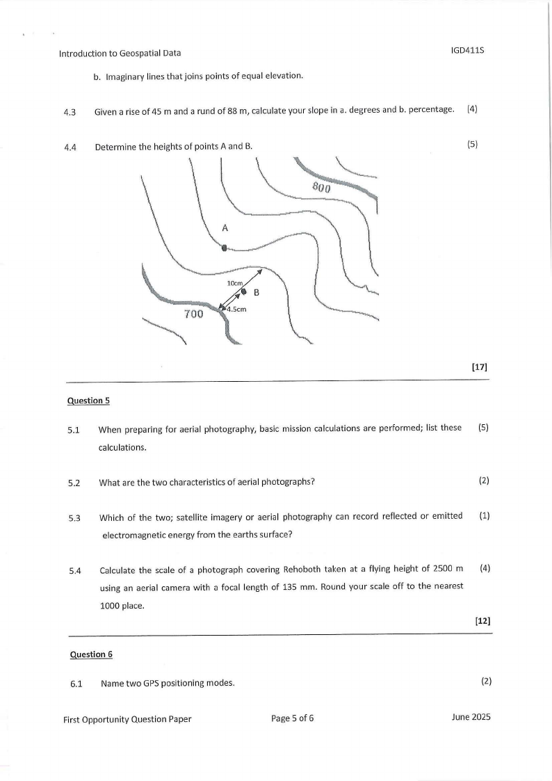
4.4 Determine the heights of points A and B.
(5)
10cm
•B
[17]
Question 5
5.1 When preparing for aerial photography, basic mission calculations are performed; list these (5)
calculations.
5.2 What are the two characteristics of aerial photographs?
(2)
5.3 Which of the two; satellite imagery or aerial photography can record reflected or emitted (1)
electromagnetic energy from the earths surface?
5.4 Calculate the scale of a photograph covering Rehoboth taken at a flying height of 2500 m (4)
using an aerial camera with a focal length of 135 mm. Round your scale off to the nearest
1000 place.
[12]
Question 6
6.1 Name two GPSpositioning modes.
(2)
First Opportunity Question Paper
Page 5 of 6
June 2025
|
|
6 Page 6 |
▲back to top |
Introduction to Geospatial Data
6.2 Name the three components that make up a GPSsystem.
IGD411S
(3)
6.3 What is the minimum number of satellites required to compute a reliable GPSposition?
(1)
6.4 What does DOP stand for?
(1)
6.5 Below are two DOPvalues. indicate the Stronger DOPvalue.
(1)
DOP value of 2
DOP value of 9
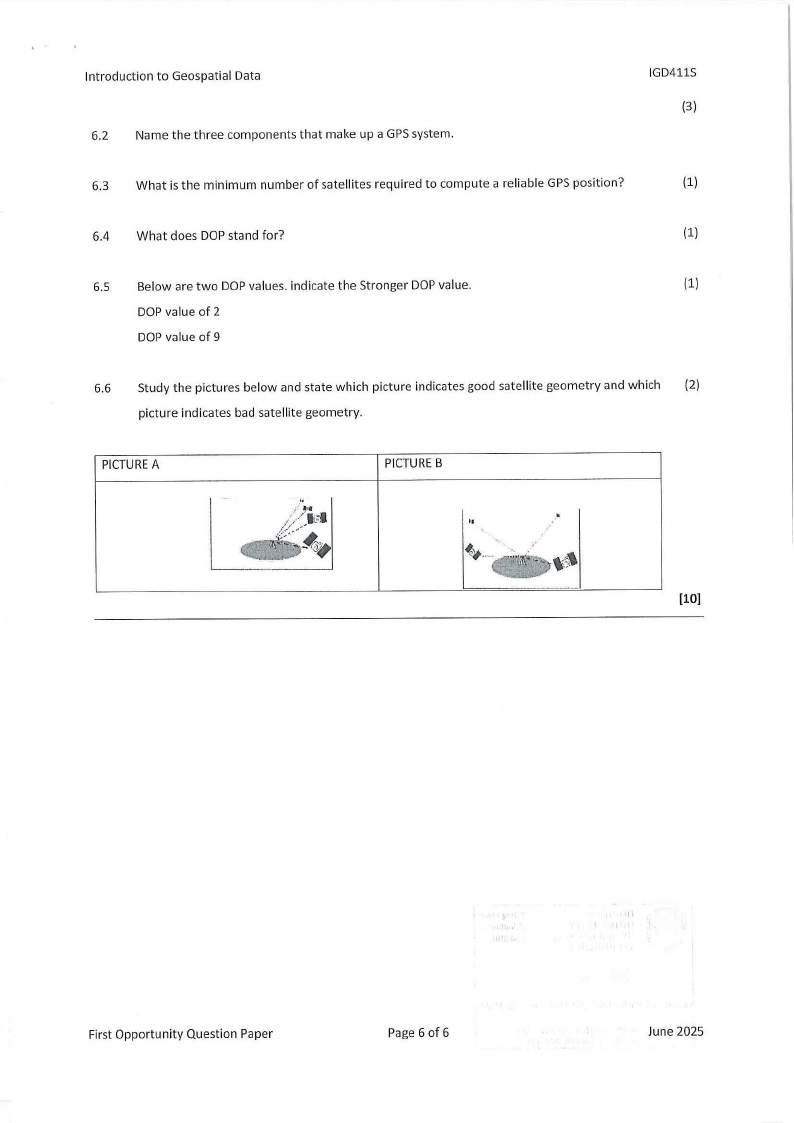
6.6 Study the pictures below and state which picture indicates good satellite geometry and which (2)
picture indicates bad satellite geometry.
PICTUREA
PICTUREB
"
(10]
First Opportunity Question Paper
Page 6 of 6
June 2025