


 |
GDG621S - GEODEMOGRAPHICS - 2ND OPP - JULY 2025 |
|
|
1 Page 1 |
▲back to top |
n Am I BI A u n IVER s ITY
OF SCIEnCE Ano TECHnOLOGY
FACULTYOF ENGINEERINGAND THE BUILTENVIRONMENT
DEPARTMENOTF LANDANDSPATIALSCIENCES
QUALIFICATION:BACHELOROF GEOINFORMATIONTECHNOLOGY
QUALIFICATIONCODE:07BGEI
COURSECODE: GDG621S
SESSION:
DURATION:
JUNE 2025
3 HOURS
QUALIFICATIONLEVEL:7
COURSENAME: GEODEMOGRAPHICS
PAPER:
MARKS:
THEORY
100
SECONDOPPORTUNITY/SUPPLEMENTARYEXAMINATION QUESTIONPAPER
EXAMINER:
Ms Ivonne Makanda
MODERATOR:
Ms Celeste Espach
THIS QUESTIONPAPER CONSISTSOF (3) PAGES
(Excluding this front page)
INSTRUCTIONS
1. Write clearly and neatly
2. Answer ALLthe questions.
3. Number the answers clearly.
PERMISSIBLEMATERIALS
1. Examination paper.
2. Examination script.
3. Calculator, ruler, pencils, eraser
|
|
2 Page 2 |
▲back to top |
Geodemographics
Question 1
GDG621S
1.1. Explain the importance of geodemographic cluster segmentation. How does it benefit
businesses and government services?
(4)
1.2. RStudio Basics
a) Write an R command on how you would create a data frame with two
columns: "Region" (values: "Khomas", "Oshana", "Erongo", "Zambezi") and
"Population" (values: 1000, 2500, 1800, 2200).
(2)
b} Write an R command to calculate the mean population from the data frame
you created.
(2)
c) Write an R command to find the median population from the data frame.
(2)
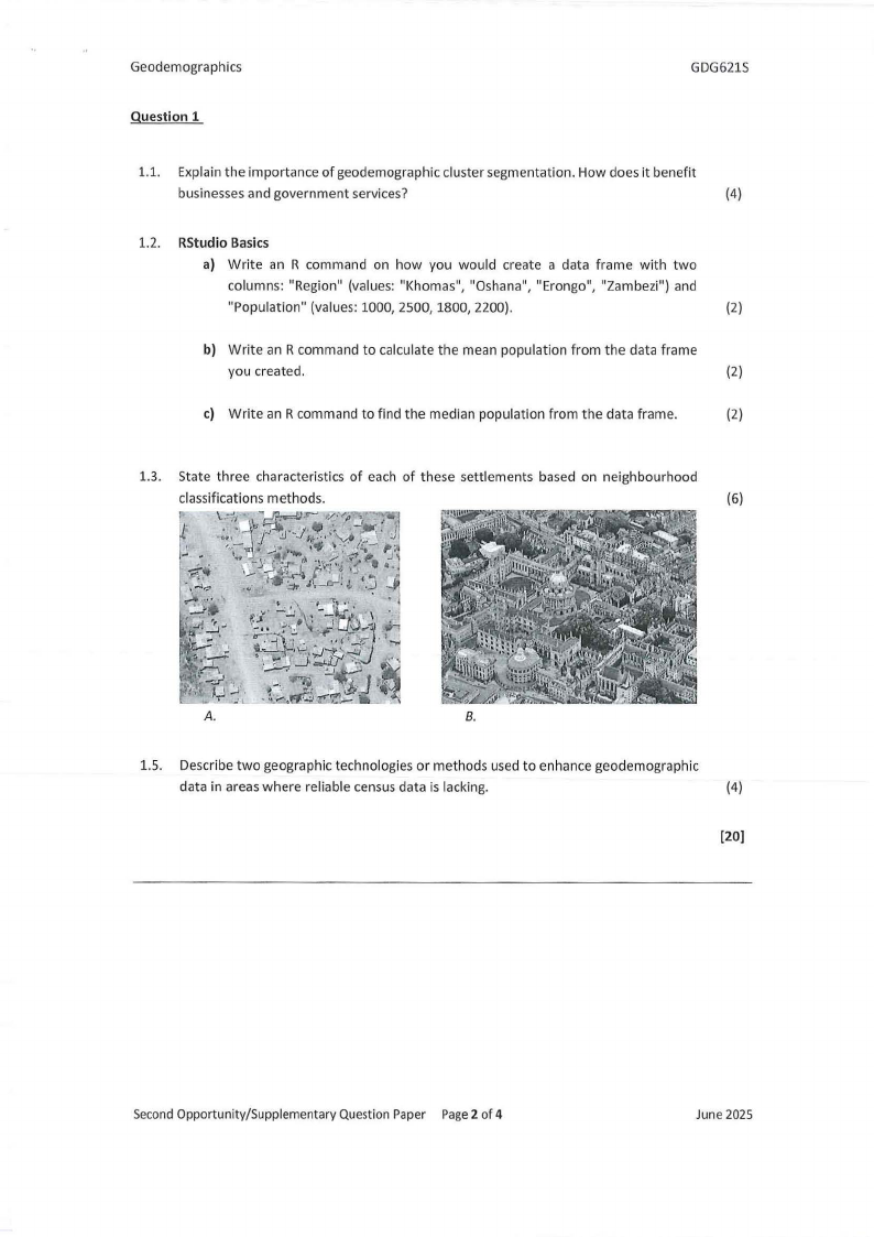
1.3. State three characteristics of each of these settlements based on neighbourhood
classifications methods.
(6)
..!
,j ·.1•~J•.:• -,',-_•..) . \\.~. ,, ~\\; 7~.-
V· ,-,,,,. "
~- ,. -•u,,,-'l
"-,
'
I. . . •
\\•,·
/:--
.. _.J" ......
.....
-~,
J..
\\: s-k-i:~-i~f·~~:";• •.
. "" ~- :::,, I
'•J:;,,<..:".'JI
A.
B.
1.5. Describe two geographic technologies or methods used to enhance geodemographic
data in areas where reliable census data is lacking.
(4)
(20)
SecondOpportunity/Supplementary Question Paper Page2 of 4
June 2025
|
|
3 Page 3 |
▲back to top |
Geodemographics
GDG621S
Question 2
2.1. Explain the importance of geodemographic cluster segmentation. How does it benefit
businesses and government services?
(6)
2.2. Discuss one advantage and one disadvantage of using GPS technology in
geodemographic fieldwork.
(4)
2.3. Explain the importance of defining neighbourhood units and inner characteristics in
geodemographic studies.
(6)
2.4. Outline the steps involved in building a geodemographic classification system from
census data.
(5)
2.5. What are two reasons why census-based geodemographic systems may differ
between developed and developing countries?
(4)
(25)
Question 3
3.1. What are two key preparatory steps required before conducting field-based
geodemographic data collection?
(4)
3.2. Describe three spatial factors that influence retail location strategy.
(6)
3.3. Scenario:
A retail pharmacy chain in Namibia wants to expand its services beyond Windhoek
into smaller towns and rural areas. The company has access to demographic and
health data, including poverty rates, education levels, accessto services, and mobile
coverage. It wants to use a geodemographic approach to:
• Select optimal store locations,
• Understand the needs of different communities, and
• Support the Ministry of Health and Social Services (MoHSS) by improving
medicine accessibility.
As a geodemographic consultant, you are asked to prepare a brief strategy using
geodemographic principles.
Second Opportunity/Supplementary Question Paper Page3 of 4
June 2025
|
|
4 Page 4 |
▲back to top |
Geodemographics
GDG621S
Question:
Using the scenario above, explain how geodemographic methods and data (including
census, remote sensing, and deprivation indicators) can be used to:
a) Segment and profile communities.
b) Identify optimal store locations.
c) Support the Ministry of Health and Social Services' equitable medicine distribution.
d) Discusstwo limitations of relying only on census data for this purpose.
{20)
[30]
Question 4
4.1. What is Body Mass Index (BMI) and why is it considered a direct measure of
deprivation? Mention one limitation.
(5)
4.2. Define inequality. What does a high Gini coefficient indicate about a country's
economic structure?
(4)
4.3. List and describe any four domains of the Multiple Deprivation Index (MDI) used in
Namibia.
(8)
4.4. Describe trade area analysis. Compare the three theoretical models used to
approximate customer patronage.
{8)
[25]
Second Opportunity/Supplementary Question Paper Page4 of 4
June 2025