


 |
GRS62S1 - APPLICATION OF GIS AND REMOTE SENSING IN AGRICULTURE - 1ST OPP - NOV 2022 |
|
|
1 Page 1 |
▲back to top |
nAm I BI A u n IVE RS ITV
OF SCIEn CE Ano TECHn OLOGY
FACULTYOF HEALTH,NATURALRESOURCESAND APPLIEDSCIENCES
DEPARTMENTOF AGRICULTUREAND NATURALRESOURCESSCIENCES
QUALIFICATION: Bachelor of Agriculture
QUALIFICATIONCODE: 07BAGA
COURSECODE: GRS621S
DATE:November2022
DURATION: 3 Hours
LEVEL:6
COURSENAME: Applications of GISand Remote Sensing
in Agriculture
PAPER: THEORY
MARKS: 85
FIRSTOPPORTUNITY EXAMINATION QUESTION PAPER
EXAMINER(S)
MODERATOR:
Prof. Vera De Cauwer
Dr Jonathan Kamwi
INSTRUCTIONS
1. Write clearly and neatly.
2. Number your answers clearly.
3. Make sure your student number appears on the answering script.
4. Include the formulas used for each calculation.
PERMISSIBLEMATERIALS
1. Calculator
THIS QUESTIONPAPERCONSISTSOF 4 PAGES(Including this front page)
1
|
|
2 Page 2 |
▲back to top |
Question 1
[6]
a) Explain what a GIS is.
b) What can you do with a GIS?
Question 2
[12]
Convert the following coordinates to decimal format.
1. 20° 18.9' S, 15° 54.8' E
2. S 25° 25.1251', E 19 ° 19.2581'
3. 18° 59' 55" s, 23° 4' 22" w
Question 3
[6]
You start a new project in QGISand you add roads.km I and regions.shp to the project. The file
extension "shp" stands for ........... Next to regions.shp, two other files are needed to open regions:
.......................a. nd ............................The files roads and regions are two ......................................of your
GIS project. Both files contain data in ....................format.
Question 4
[4]
What is the difference between geographical and projected coordinates?
Question 5
[18]
Indicate if following statements are True or False. If false, correct the statement.
1. A GPScollects geospatial data.
2. Visible light contains less energy than radio waves.
3. A vector line consists of minimum two vertices.
4. Vector data are made out of pixels.
5. Satellite images record the light absorbed by objects.
6. Chlorophyll absorbs green light.
7. Longitude varies from 0° at Greenwich to 180° east or west.
8. UTM (Universal Transverse Mercator) is a projected coordinate system.
9. A GPSreceiver allows to determine the exact location for any spot on earth.
10. Topographic maps always show contour lines.
11. Coordinates of latitude are represented on the X-axis of a map.
12. Electromagnetic radiation travels at the speed of sound (343 m/s).
13. Humans emit infrared radiation.
Question 6
[9]
How can you obtain GIS data for your study area?
2
|
|
3 Page 3 |
▲back to top |
Question 7
[3]
a) What is the difference between accuracy and precision of a distance measurement in a GIS?
b) If we measure a distance of 1205.1 m: what is the precision?
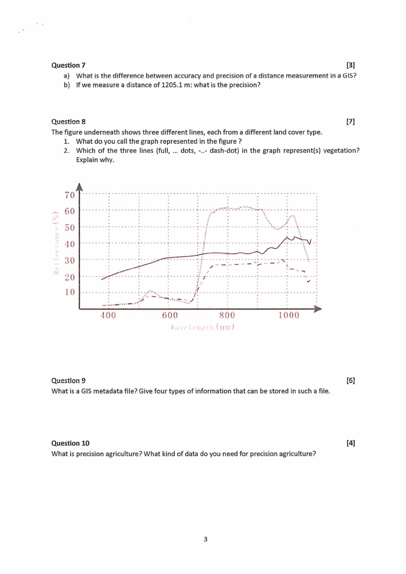
Question 8
[7]
The figure underneath shows three different lines, each from a different land cover type.
1. What do you call the graph represented in the figure?
2. Which of the three lines (full, ... dots, -..- dash-dot) in the graph represent(s) vegetation?
Explain why.
70
,0
. . .. - .. - ... : ..... : - - . - .. - - ... . - - ......
'
' - .. .:-.·.-,,·,·..·.:.::.; ..·.-·:.:._:.':. ...:...·.·.....-.....
-:...-.,-.
.......
··.,
:.
::-o -------- .-------:-------. ---.---- --i .. -....:-. ---.. -- ----:..:..,-.; ...\\._-... :
-:
,10
•••••••••••
-
•••
'~-
........................
.
..: •
..;
.................................
·..-.,
....
.
..
30
20
!O
,100
600
I ( 00
Question 9
[6]
What is a GIS metadata file? Give four types of information that can be stored in such a file.
Question 10
[4]
What is precision agriculture? What kind of data do you need for precision agriculture?
3
|
|
4 Page 4 |
▲back to top |
(.
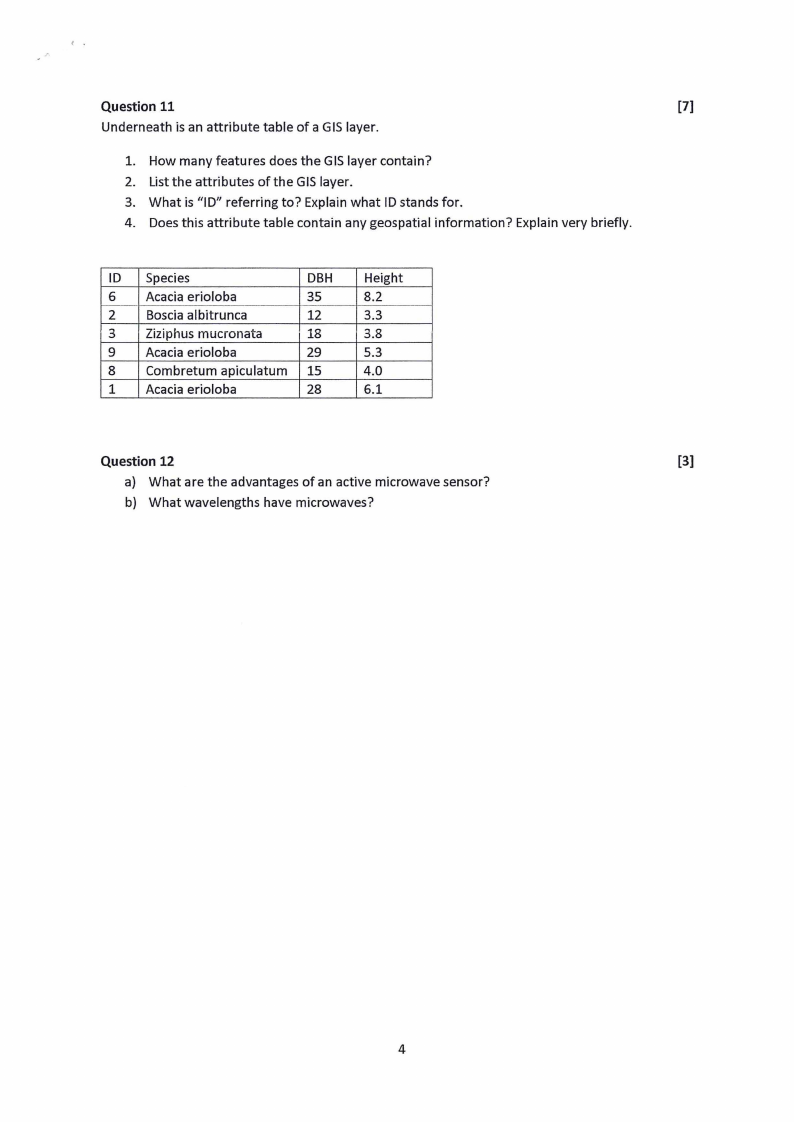
Question 11
[7]
Underneath is an attribute table of a GIS layer.
1. How many features does the GIS layer contain?
2. List the attributes of the GIS layer.
3. What is "ID" referring to? Explain what ID stands for.
4. Does this attribute table contain any geospatial information? Explain very briefly.
ID Species
DBH
6 Acacia erioloba
35
2 Boscia albitrunca
12
3 Ziziphus mucronata
18
9 Acacia erioloba
29
8 Combretum apiculatum 15
1 Acacia erioloba
28
Height
8.2
3.3
3.8
5.3
4.0
6.1
Question 12
[3]
a) What are the advantages of an active microwave sensor?
b) What wavelengths have microwaves?
4