


 |
GRS62S1 - APPLICATION OF GIS AND REMOTE SENSING IN AGRICULTURE - 2ND OPP - JAN 2023 |
|
|
1 Page 1 |
▲back to top |
r
.i
nAmlBIA UnlVERSITY
OF SCIEnCE Ano TECHnOLOGY
FACULTOYFHEALTHN; ATURALRESOURCAENSDAPPLiEDSCiENCES
DEPARTMENTOFAGRICULTUREAND NATURALRESOURCESCIENCES
QUALIFICATION: Bachelor of Agriculture
QUAiJFitA'fioNGODE6: 7BAGA
COURSECODE: GRS621S
DATE:January 2023
DURATION: 3 Hours
LEVEL6:
COURSENAME: Applications of GISand Remote Sensing
in Agriculture
PAPER: THEORY
MARKS: 85
SECOND OPPORTUNITY EXAMINATION QUESTION PAPER
EXAMINER(S)
MODERATOR:
Prof. Vera De Cauwer
Dr Jonathan Kamwi
iNSfRUctioNs
1. Write clearly and neatly.
2. Number your answers clearly.
3. Makesureyour studentnumoerappearsontheanswerinsgcript.
4. inGlude the formulas used for eaGhGalGulation,
PERMISSIBLE MATERIALS
i. Caicuiator
THIS QUESTIONPAPERCONSISTSOF 3 PAGES(Including this front page)
1
|
|
2 Page 2 |
▲back to top |
Question 1
[4]
What is the difference between spatial and geospatial data? Explain briefly
Question 2
[16]
Convert the following coordinates to decimal format.
1. 16° 6.9' S, 23° 55.9' E
2. S 45° 45.6258', E 29° 15.5582'
3. 18° 19' 36" s, 21° 54' 2" w
4. S 28° 59', E 23° 8'
Question 3
[6]
What is the difference between vector and raster data?
Question 4
What does GPSstand for? Describe in detail what it is and how it works.
Question 5
[18]
Indicate if following statements are True or False. If false, correct the statement.
l. Electromagnetic radiation with a long wavelength has a low frequency.
2. A satellite image contains geospatial information in vector format.
3. Polygons are composed of at least 2 vertices that are connected.
4. Each cell of a raster image stores a single value.
5. Green plants absorb green light.
6. The location 1,215,000 m E, 581,355 m Sis expressed in geographical coordinates.
7. Coordinates of latitude represent the X-axis for the grid of latitude and longitude lines
covering the world.
8. You can not open a QGIS project on a computer without having the GIS data used in the
project.
9. The latitude at the equator is 90°.
10. GPSdata is vector data and most often in gpx format.
11. The EISis a local data repository that contains GIS data.
12. A map scale of 1:250,000 is larger than a map scale of 1:25,000.
Question 6
[7]
Why is it important to assess the quality of GIS data? What are the key components to evaluate
geospatial data quality?
Question 7
[3]
What is terrain relief? How can you display terrain relief on a map?
2
|
|
3 Page 3 |
▲back to top |
Question 8
[5]
What is the difference between active and passive remote sensing sensors?
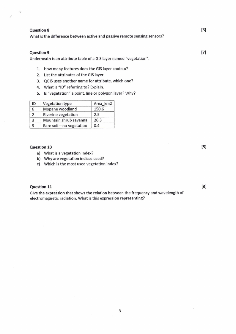
Question 9
[7]
Underneath is an attribute table of a GIS layer named "vegetation".
1. How many features does the GIS layer contain?
2. List the attributes of the GIS layer.
3. QGISuses another name for attribute, which one?
4. What is "ID" referring to? Explain.
5. Is "vegetation" a point, line or polygon layer? Why?
ID Vegetation type
Area km2
6 Mopane woodland
150.6
2 Riverine vegetation
2.5
3 Mountain shrub savanna 26.3
9 Bare soil - no vegetation 0.4
Question 10
[5]
a) What is a vegetation index?
b) Why are vegetation indices used?
c) Which is the most used vegetation index?
Question 11
[3]
Give the expression that shows the relation between the frequency and wavelength of
electromagnetic radiation. What is this expression representing?
3