


 |
BSV521S - BASIC SURVEYING - 2ND OPP - JULY 2022 |
|
|
1 Page 1 |
▲back to top |
nAmlBIA UnlVERSITY
OF SCIEn CE Ano TECHn OLOGY
FACULTYOF ENGINEERINGAND SPATIALSCIENCES
DEPARTMENTOF ARCITECTUREAND SPATIALSCIENCES
QUALIFICATIONS:
BACHELOROF GEOMATICS and DIPLOMA IN GEOMATICS
QUALIFICATIONSCODES:
07BGEO,06DGEO
QUALIFICATION LEVEL:
Level 7 - 07BGEO
Level 6 - 06DGEO
COURSECODE: BSV521
COURSENAME: Basic Surveying
DATE: July 2022
PAPER:THEORY
DURATION: 3 HOURS
MARKS: 100
SECONDOPPORTUNITY/SUPPLEMENTARYEXAMINATION QUESTION PAPER
EXAMINER:
Mr F. J. Louw
MODERATOR:
Mr S. Sinvula
INSTRUCTIONS
1. You MUST answer ALLQUESTIONS
2. Write clearly and neatly.
3. Number the answers clearly.
4. Make sure your Student Number is on the EXAMINATION BOOK(s).
5. MAKE SUREYOUR STUDENTNUMBER IS ON ALLTHE DATA SHEETSAND
THAT YOU SUBMIT THEM WITH YOUR EXAMINATION BOOK(S).
PERMISSIBLEMATERIALS
1. Calculator, ruler, pencil and eraser.
THIS QUESTION PAPERCONSISTSOF 6 PAGES(Including this front page and 2 Data Sheets)
|
|
2 Page 2 |
▲back to top |
Basic Surveying
BSV521S
Question 1
1.1. Distinguish between Precise Observations and Accurate Observations.
(2)
1.2. Distinguish between the terms Grid and Graticule.
(2)
1.3. Why should intermediate sights onto important points be avoided during levelling?
(2)
1.4. Briefly describe ANY FOURcharacteristics of Contours.
(4)
1.5. What are the purposes of a Reference Object (R/O)?
(3)
1.6. Name the THREErequirements of a Reference Object(R/O).
(3)
1.7. There are two principal classifications of surveying, name ANY ONE and fully explain it.
(2)
1.8. Briefly explain how a surveyor would take a level reading under a bridge. What is this method
called?
(2)
[20]
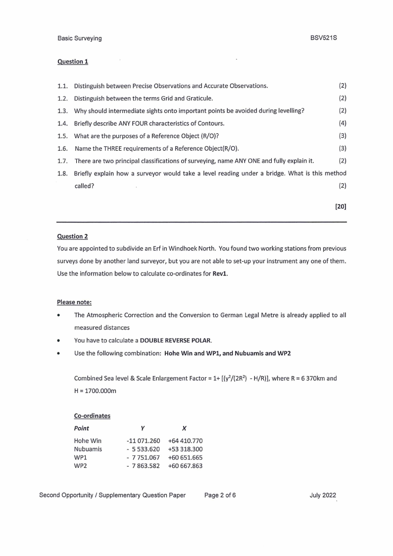
Question 2
You are appointed to subdivide an Erf in Windhoek North. You found two working stations from previous
surveys done by another land surveyor, but you are not able to set-up your instrument any one of them.
Use the information below to calculate co-ordinates for Revl.
Please note:
• The Atmospheric Correction and the Conversion to German Legal Metre is already applied to all
measured distances
• You have to calculate a DOUBLEREVERSEPOLAR.
•
Use the following combination: Hohe Win and WPl, and Nubuamis and WP2
Combined Sea level & Scale Enlargement Factor= 1+ [(y2/(2R2) - H/R)], where R = 6 370km and
H = 1700.000m
Co-ordinates
Point
Hohe Win
Nubuamis
WPl
WP2
y
-11 071.260
- 5 533.620
- 7 751.067
- 7 863.582
X
+64410.770
+53 318.300
+60 651.665
+60 667.863
Second Opportunity / Supplementary Question Paper
Page 2 of6
July 2022
|
|
3 Page 3 |
▲back to top |
Basic Surveying
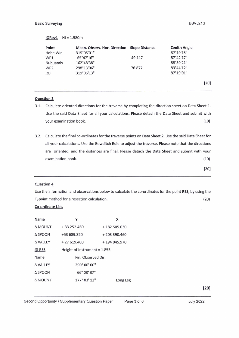
@Revl HI = 1.580m
Point
Hohe Win
WP1
Nubuamis
WP2
RO
Mean. Observ. Hor. Direction
319°05'01"
65°47'16"
162°48'38"
298°13'06"
319°05'13"
Slope Distance
49.117
76.877
BSV521S
Zenith Angle
87°19'15"'
87°42'17"'
88°59'21"
89°44'12"
87°19'01"'
[20)
Question 3
3.1. Calculate oriented directions for the traverse by completing the direction sheet on Data Sheet 1.
Use the said Data Sheet for all your calculations. Please detach the Data Sheet and submit with
your examination book.
(10)
3.2. Calculate the final co-ordinates for the traverse points on Data Sheet 2. Use the said Data Sheet for
all your calculations. Use the Bowditch Rule to adjust the traverse. Please note that the directions
are oriented, and the distances are final. Please detach the Data Sheet and submit with your
examination book.
(10)
[20)
Question 4
Usethe information and observations below to calculate the co-ordinates for the point RES,by using the
Q-point method for a resection calculation.
(20)
Co-ordinate List.
Name
y
X
t:,.MOUNT
+ 33 252.460
+ 182 505.030
!:,.SPOON
+53 689.320
+ 203 390.460
t:,V. ALLEY
+ 27 619.400
+ 194 045.970
Height of Instrument= 1.853
Name
Fin. Observed Dir.
t:,V. ALLEY
290° 00' 00"
t:,.SPOON
66° 08' 37"
t:,.MOUNT
177° 03' 12"
Long Leg
[20]
Second Opportunity / Supplementary Question Paper
Page 3 of 6
July 2022
|
|
4 Page 4 |
▲back to top |
Basic Surveying
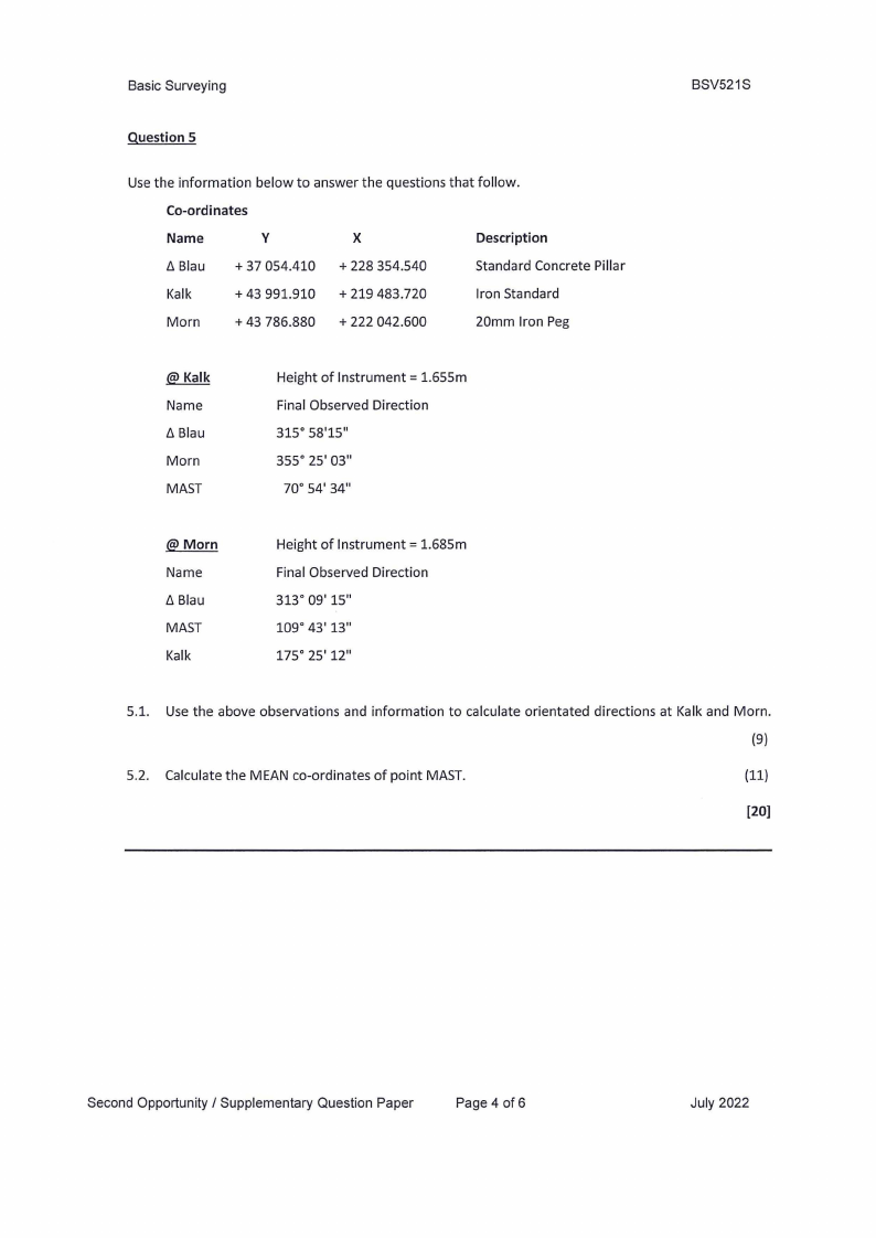
Question 5
Use the information below to answer the questions that follow.
Co-ordinates
Name
y
X
Description
t::,B. lau + 37 054.410 + 228 354.540
Standard Concrete Pillar
Kalk
+ 43 991.910 + 219 483.720
Iron Standard
Morn
+ 43 786.880 + 222 042.600
20mm Iron Peg
BSV521S
Name
t::,B. lau
Morn
MAST
Height of Instrument= 1.655m
Final Observed Direction
315° 58'15"
355° 25' 03"
70° 54' 34"
@Morn
Name
t::,B. lau
MAST
Kalk
Height of Instrument= 1.685m
Final Observed Direction
313° 09' 15"
109° 43' 13"
175° 25' 12"
5.1. Use the above observations and information to calculate orientated directions at Kalk and Morn.
(9)
5.2. Calculate the MEAN co-ordinates of point MAST.
(11)
[20]
Second Opportunity / Supplementary Question Paper
Page 4 of6
July 2022
|
|
5 Page 5 |
▲back to top |
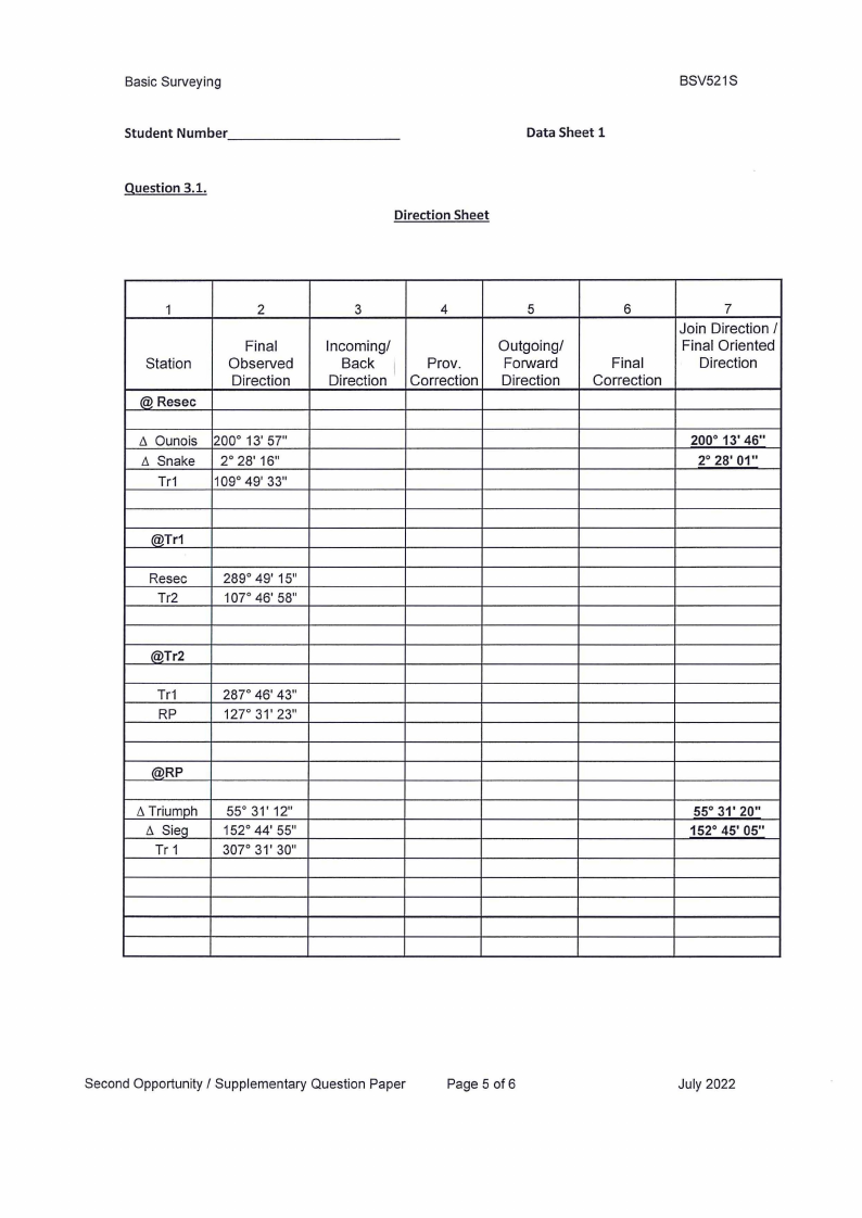
Basic Surveying
Student Number _________
Question 3.1.
_
Data Sheet 1
Direction Sheet
BSV521S
1
Station
@ Resec
2
Final
Observed
Direction
t::,.Ounois
t::,. Snake
Tr1
200° 13' 57''
2° 28' 16"
109° 49' 33"
3
4
5
Incoming/
Back
Direction
Prov.
Correction
Outgoing/
Forward
Direction
6
Final
Correction
7
Join Direction /
Final Oriented
Direction
200° 13' 46"
2° 28' 01"
®Tr1
Resec
Tr2
289° 49' 15"
107° 46' 58"
®Tr2
Tr1
RP
287° 46' 43"
127° 31' 23"
(@RP
t::,T. riumph
t::,. SieQ
Tr 1
55° 31' 12"
152° 44' 55"
307° 31' 30"
55° 31' 20"
152° 45' 05"
Second Opportunity / Supplementary Question Paper
Page 5 of 6
July 2022
|
|
6 Page 6 |
▲back to top |
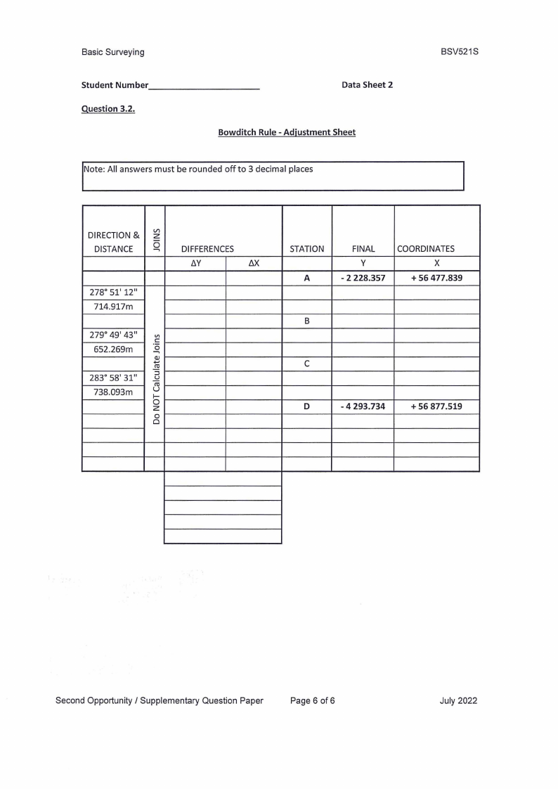
Basic Surveying
Student Number _________
Question 3.2.
_
Data Sheet 2
Bowditch Rule - Adjustment Sheet
Note: All answers must be rounded off to 3 decimal places
BSV521S
DIRECTION& zl/l
DISTANCE 0--,
DIFFERENCES
l::i.Y
/j.X
278° 51' 12"
714.917m
279° 49' 43" V)
652.269m
·aC
--,
.Q.) ,
.!!!
283° 58' 31"
:::::s
.5d
738.093m
u(0
f-
0z
0
0
STATION
A
FINAL
y
- 2 228.357
COORDINATES
X
+ 56 477.839
B
C
D
- 4 293.734
+ 56 877.519
Second Opportunity / Supplementary Question Paper
Page 6 of 6
July 2022