


 |
GES512S - GEOGRAPHIC INFORMATION SYSTEMS 1 - 1ST OPP - NOV 2023 |
|
|
1 Page 1 |
▲back to top |
nAmlBIA untVERSITY
OF SCIEn CE Ano TECHn OLOGY
FACULTY OF ENGINEERING AND THE BUILT ENVIRONMENT
DEPARTMENTOF LAND AND SPATIALSCIENCES
QUALIFICATIONS:
DIPLOMA IN GEOMATICS, BACHELOR OF GEOMATICS, BACHELOR OF GEOINFORMATION
TECHNOLOGY,DIPLOMA IN LAND ADMINISTRATION, BACHELOROF LAND ADMINISTRATION,
BACHELOROF TOWN AND REGIONALPLANNING, BACHELOROF PROPERTYSTUDIES,DIPLOMA IN
PROPERTYSTUDIES,BACHELOROF REGIONAL& RURALDEVELOPMENTBACHELOROF NATURAL
RESOURCEMANAGEMENT, BACHELOROF NATURAL RESOURCEMANAGEMENT IN NATURE
CONSERVATION
QUALIFICATIONSCODES:
LEVEL: 5
06DGEO,07BGEO,06DLAD, 07BLAM,
07BTAR,06DPRS,08BPRS,07BRAR,
07BNRS, 07BNTC
COURSECODE:GESS12S
COURSENAME: GEOGRAPHICINFORMATION
SYSTEMS1
DATE: NOVEMBER 2023
SESSION: 1
DURATION: 3 HOURS
MARKS: 100
FIRST OPPORTUNITY EXAMINATION QUESTION PAPER
EXAMINER:
MS ROXANNEMURANGI
MODERATOR: MR MIGUEL VALLEJO
INSTRUCTIONS
1. Write your student number on each answer sheet used.
2. Answer ALLthe questions.
3. Read each question carefully before attempting to answer.
4. Write clearly and neatly.
PERMISSIBLEMATERIALS
1. Pen
2. Pencil
3. Ruler and Eraser
This paper consists of four (4) pages (excluding this cover page)
|
|
2 Page 2 |
▲back to top |
Geographic Information Systems 1
Question 1
Define the following terms in the GIScontext:
1.1. Topography
1.2. Polygon overlay
1.3. Datum
1.4. Geographic analysis
1.5. Geocode
GES512S
(2)
(2)
(2)
(2)
(2)
[10]
Question 2
2.1. You have been contracted to provide GIS consultancy service to Erongo Regional
Council on acquiring a Geographical Information System (GIS)software. Your first task
is to convince the Chief Regional Officer and his three officials that GISis an ideal tool
for planning and decision-making. Write a short memo to the Council explaining:
a) What GISis.
(3)
b) The different functions of a GIS.
(8)
c) Provide five advantages of using GISinstead of traditional paper maps and manual
analysis.
(5)
2.2. A sophisticated GIS can answer five types of questions. Briefly discuss the questions
"What if (modelling)?", "Where it is?", and "What is at?". Provide one example for
each question.
(6)
First Opportunity Exam Question Paper
Page 2 of 5
November 2023
|
|
3 Page 3 |
▲back to top |
Geographic Information Systems 1
GES512S
2.3. Differentiate between spatial data and non-spatial data. Provide two examples for
each.
(4)
2.4. Explain the two types of GIS concepts.
(4)
2.5. Explain what a GISlayer is. Outline any five additional GISprinciples.
(6)
[36]
Question 3
3.1. What is the difference between a coordinate and a coordinate axis?
(2)
3.2. Explain the differences between geographic and projected coordinate systems.
(8)
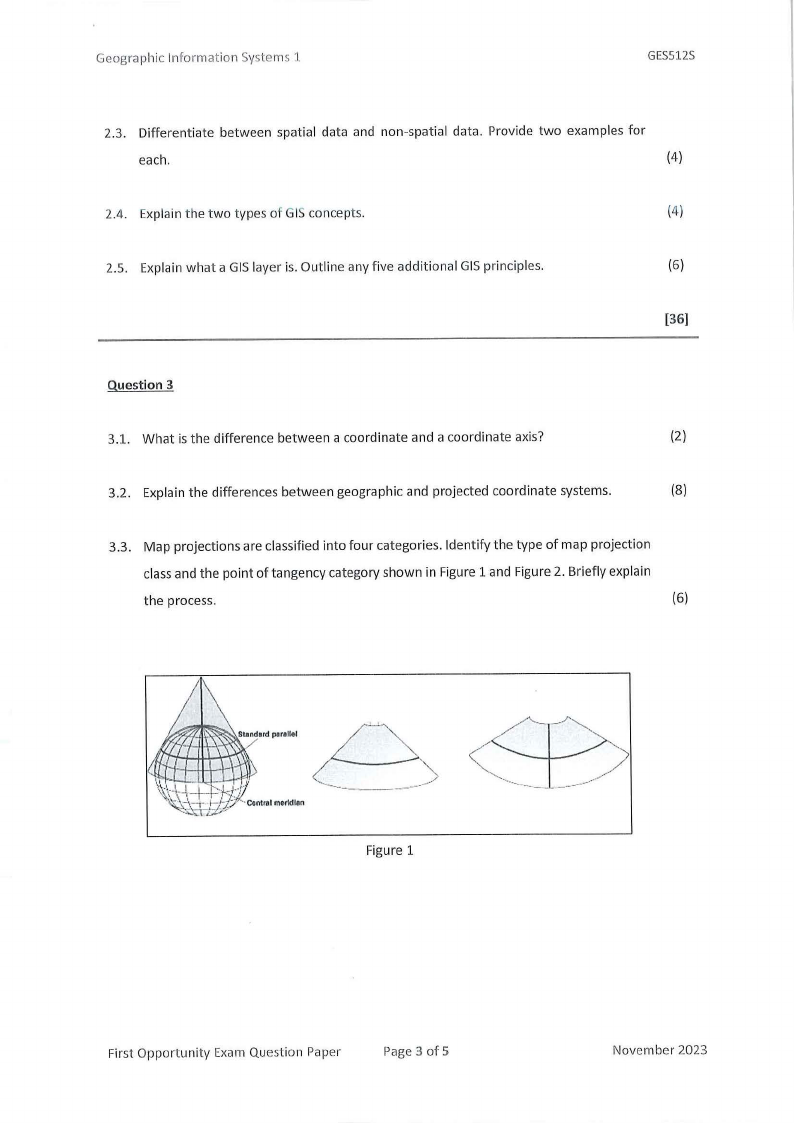
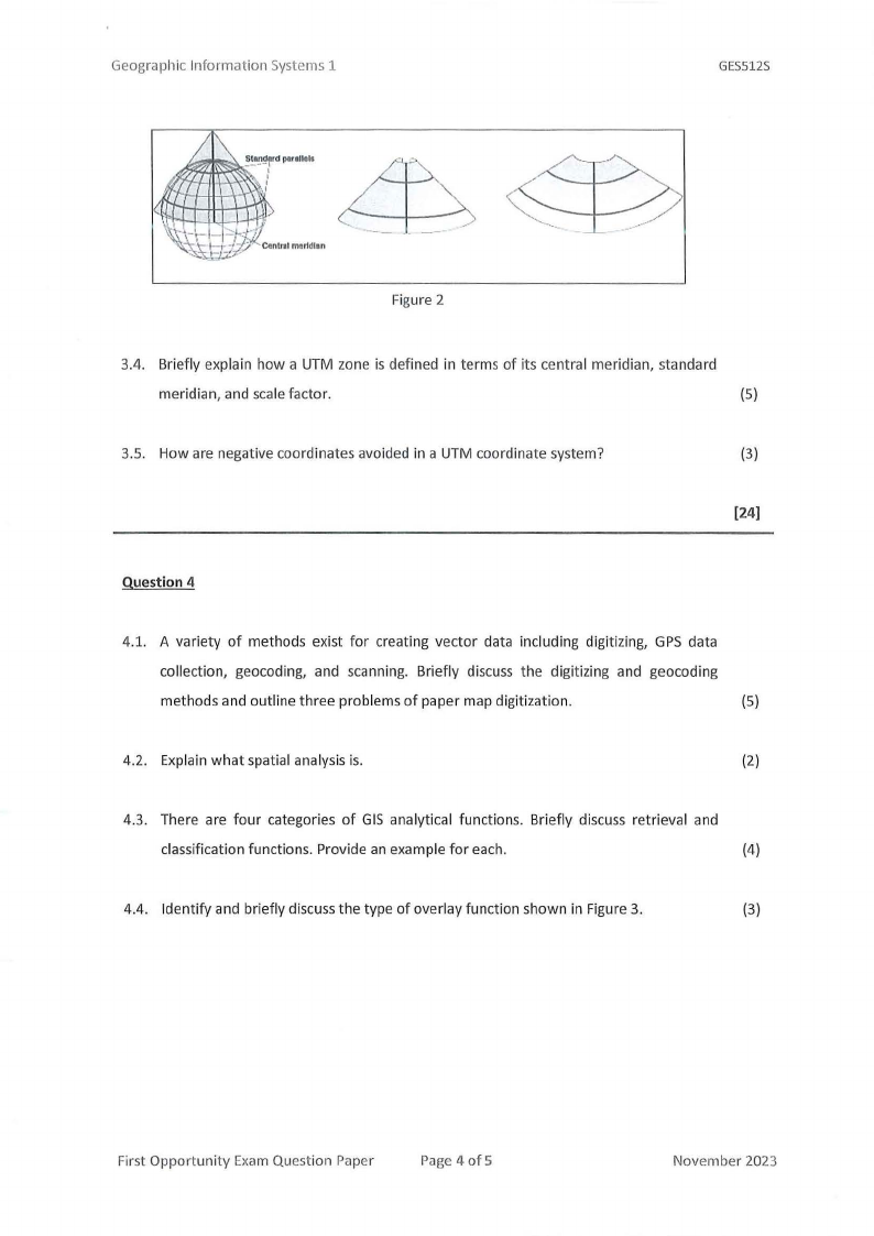
3.3. Map projections are classified into four categories. Identify the type of map projection
classand the point of tangency category shown in Figure 1 and Figure 2. Briefly explain
the process.
(6)
Figure 1
First Opportunity Exam Question Paper
Page 3 of 5
November 2023
|
|
4 Page 4 |
▲back to top |
Geographic Information Systems 1
GES512S
Figure 2
3.4. Briefly explain how a UTM zone is defined in terms of its central meridian, standard
meridian, and scale factor.
(5)
3.5. How are negative coordinates avoided in a UTM coordinate system?
(3)
[24]
Question 4
4.1. A variety of methods exist for creating vector data including digitizing, GPS data
collection, geocoding, and scanning. Briefly discuss the digitizing and geocoding
methods and outline three problems of paper map digitization.
(5)
4.2. Explain what spatial analysis is.
(2)
4.3. There are four categories of GIS analytical functions. Briefly discuss retrieval and
classification functions. Provide an example for each.
(4)
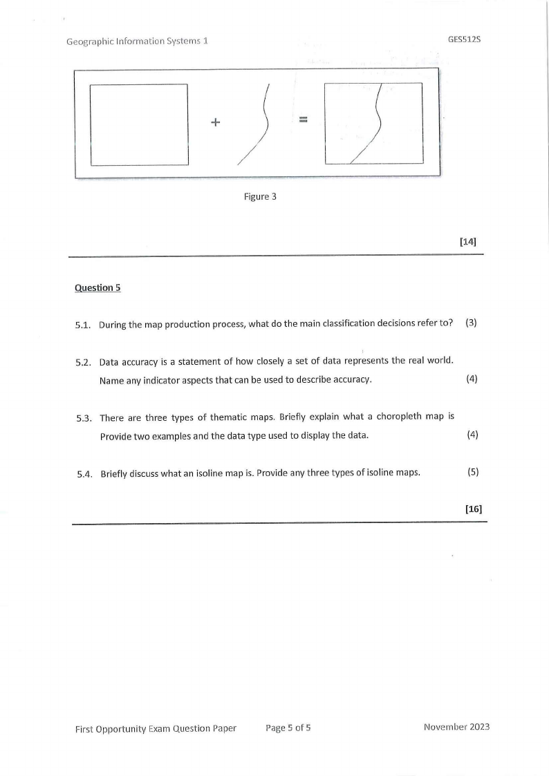
4.4. Identify and briefly discuss the type of overlay function shown in Figure 3.
(3)
First Opportunity Exam Question Paper
Page 4 of 5
November 2023
|
|
5 Page 5 |
▲back to top |
Geographic Information Systems 1
GES512S
+
=
/
Figure 3
[14]
Question 5
5.1. During the map production process, what do the main classification decisions refer to? (3)
5.2. Data accuracy is a statement of how closely a set of data represents the real world.
Name any indicator aspects that can be used to describe accuracy.
(4)
5.3. There are three types of thematic maps. Briefly explain what a choropleth map is
Provide two examples and the data type used to display the data.
(4)
5.4. Briefly discuss what an isoline map is. Provide any three types of isoline maps.
(5)
[16]
First Opportunity Exam Question Paper
Page 5 of 5
November 2023