


 |
GES512S - GEOGRAPHIC INFORMATION SYSTEMS 1 - 2ND OPP - DEC 2025 |
|
|
1 Page 1 |
▲back to top |
n Am I BI A u n IVER s I TY
OF SC IEnCE Ano TECHnOLOGY
FACULTY OF ENGINEERING AND THE BUILT ENVIRONMENT
DEPARTMENT OF LAND AND SPATIAL SCIENCES
QUALIFI CATION S:
DIPLOMA IN PROPERTY STUDIES, DIPLOMA IN GEOMATICS, BACHELOR OF GEOMATICS, BACHELOR
OF PROPERTY STUDIES, BACHELOR OF LAND ADMINISTRATION, BACHELOR OF GEOINFORMATION
TECHNOLOGY, BACHELOR OF REGIONAL AND RURAL DEVELOPMENT, BACHELOR OF TOWN & REG.
PLANNING, BACHELOR OF URBAN AND REGIONAL PLANNING
QUALIFICATION CODES:
LEVEL:
06DIPS, 06DPRS, 06DGEO, 07BLAM, 07BGEO, Level 6 - 06DIPS, 06DPRS, 06DGEO
07BGE I, 07BORR, 07BRAR, 07BTAR, 07BURP, Level 7 - 07BLAM, 07BGEO, 07BGEI, 07BORR,
08BOPS, 08BPRS
07BRAR, 07BTAR, 07BURP
Level 8 - 08BOPS, 08BPRS
COURSE CODE: GES512S
COURSE NAME: GEOGRAPHIC INFORMATION
SYSTEMS 1
SESSION: DECEMBER 2025
PAPER: THEORY
DURATION: 3 HOURS
MARKS: 100
SECOND OPPORTUNITY/ SUPPLEMENTARY EXAMINATION QUESTION PAPER
EXAMINER
Mr Ryan Benade
MODERATOR:
Mr Erich Naoseb
THIS QUESTION PAPER CONSISTS OF (6) PAGES
(Excluding this front page)
INSTRUCTIONS
1. Write clearly and neatly
2. Answer ALL the questions.
3. Number the answers clearly.
PERMISSIBLE MATERIALS
1. Examination paper.
2. Examination script.
3. Calculator, ruler, pencils, eraser
|
|
2 Page 2 |
▲back to top |
(,eogr,1pl\\ir. Information Systems 1
Question 1
GES512S
Answer the multiple-choice questions listed below. Please select the ONE most relevant to the
fol lowing questions. Indicate the correct answer on the answer sheet.
1.1 GIS is defined as:
(1)
A. A tool for drawing maps only
B. A computer-based system for capturing, storing, ana lysing and displaying spatial data
C. A statistical package for processing numerical data
D. A network of sate llites for positioning
1.2 Which of the following is not a component of a GIS?
(1)
A. Hardware
B. Software
C. People
D. Climate
1.3 Discrete phenomena include:
(1)
A. Temperature
B. Rainfall
C. Rivers and pa rcels
D. Elevation
1.4 In a raster data model, the smallest unit of data is called:
(1)
A. Node
B. Pixel
C. Vertex
D. Polygon
Second Opportunity/Supplementary Question Paper
Page 2 of 7
December 2025
|
|
3 Page 3 |
▲back to top |
Geogr aphir Information Systems 1
GCS512S
1.5 A map projection that preserves area is called:
(1)
A. Conformal projection
B. Azimuthal projection
C. Equivalent projection
D. Mercator projection
1.6 The unique identifier linking attribute data to spatial data is:
(1)
A. Foreign key
B. Projection
C. Datum
D. FID
1.7 Which GISfunction finds features within a specified distance of another feature?
(1)
A. Overlay analysis
B. Proximity analysis
C. Network analysis
D. Rasterisation
1.8 Which of the following is not an essential element of a map?
(1)
A. Legend
B. North arrow
C. Title
D. Paragraph text
1.9 Large-scale maps are:
(1)
A. More detailed, covering small areas
B. Less detailed, covering large areas
C. Always thematic maps
D. Always topographic maps
Second Opportunity/Supplementary Question Paper
Page 3 of 7
December 2025
|
|
4 Page 4 |
▲back to top |
Geographic lnforrnr1lion Sy~tems 1
1.10. The main national mapping agency of Namibia is:
A. NASA
8. Directorate of Survey and Mapping
C. Namibia Meteorological Services
D. United Nations Cartography Division
Gl~517.S
(1)
[10]
Question 2
2.1 GIS can be used to address 5 different types of questions. List and explain any three kinds of
(6)
questions that GIS can answer.
2.2 List and describe four functions of a Geographic Information System.
(8)
2.3 What is the role of false easting and false northing in map projections and why are they
(2)
applied in coordinate systems?
2.4 Discuss the limitations of using a Geographic Coordinate System for distance and area
(4)
calcu lations and explain how a Projected Coordinate System overcomes these issues.
[20]
Question 3
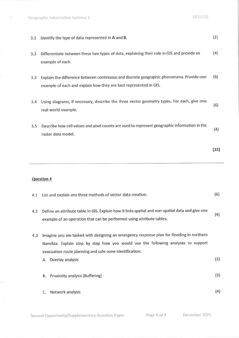
A
B
{=-::J,~ Id
T)\\'.M'
2 ,. -
lB'°"'b
◄ ;\\<AN
S Tttff\\NN
6 C4m<!tho<n
7 !K>,lbf""
H"9hl(m)
"''"'
18 Fr\\.llt,ng
IS •~hy
H U~tutt
12 Hullhy
10 H"lthy
20 IIHlh'/
ll I1,~,hy
Figure 1 shows two representations of data used in a Geographic Information System
Second Opportunity/Supplementary Question Paper
Page 4 of 7
December 2025
|
|
5 Page 5 |
▲back to top |
Geographic lnfurrnr1tio11 Systems 1
GESS12S
3.1 Identify the type of data represented in A and B.
(2)
3.2 Differentiate between these two types of data, explaining their role in GIS and provide an
(4)
example of each.
3.3 Explain the difference between continuous and discrete geographic phenomena. Provide one (6)
example of each and explain how they are best represented in GIS.
3.4 Using diagrams, if necessary, describe the three vector geometry types. For each, give one
(6)
real-world example.
3.5 Describe how cell values and pixel counts are used to represent geographic information in the
(4)
raster data model.
[22)
Question 4
4.1 List and explain any three methods of vector data creation.
(6)
4.2 Define an attribute table in GIS. Explain how it links spatial and non-spatial data and give one
(4)
example of an operation that can be performed using attribute tables.
4.3 Imagine you are tasked with designing an emergency response plan for flooding in northern
Namibia. Explain step by step how you would use the following analyses to support
evacuation route planning and safe-zone identification:
A. Overlay analysis
(3)
B. Proximity analysis (Buffering)
(3)
C. Network analysis
(4)
Second Opportunity/Supplementary Question Paper
Page 5 of 7
December 2025
|
|
6 Page 6 |
▲back to top |
Geographic l11formation Systems 1
GESS12S
[20]
Quest ion 5
5.1 Imagine you are creating a GIS map of health facilities in Namibia. Distinguish between
qualitative and quantitative data you would collect and explain how each type could be (4)
represented cartographically.
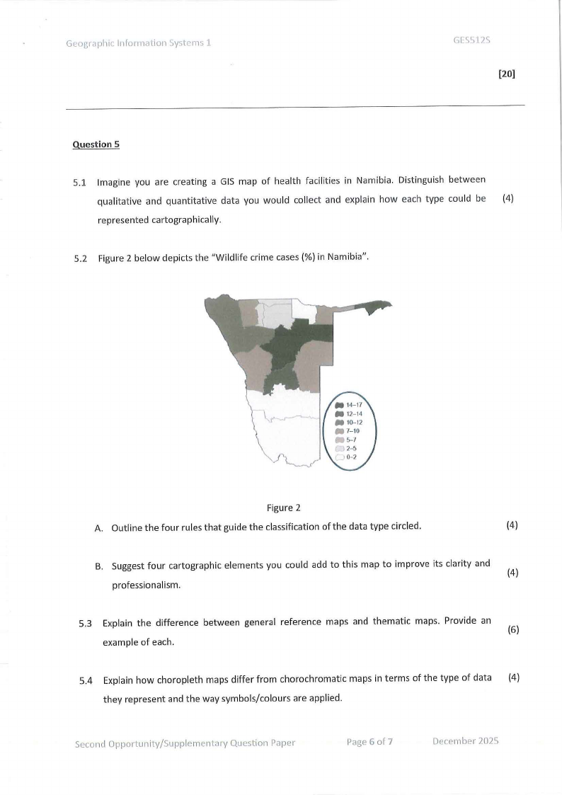
5.2 Figure 2 below depicts the "Wildlife crime cases(%) in Namibia".
Figure 2
A. Outline the four rules that guide the classification of the data type circled.
(4)
B. Suggest four cartographic elements you could add to this map to improve its clarity and
(4)
professionalism.
5.3 Explain the difference between general reference maps and thematic maps. Provide an
(6)
example of each.
5.4 Explain how choropleth maps differ from chorochromatic maps in terms of the type of data (4)
they represent and the way symbols/colours are applied.
Second Opportunity/Supplementary Question Paper
Page 6 of 7
December 2025
|
|
7 Page 7 |
▲back to top |
Geogt c1phic l11fomwlio11 Syst em s l
GLS512S
5.5 Describe the principles of cartographic design. Explain how any three of these improve map
(6)
communication
[28]
Second Opportunity/Supplementary Question Paper
Page 7 of 7
December 2025