


 |
GES512S - GEOGRAPHIC INFORMATION SYSTEMS 1 - 1ST OPP - NOV 2025 |
|
|
1 Page 1 |
▲back to top |
nAmlBIA UnlVERSITY
OF SCIEnCE Ano TECHnOLOGY
FACULTY OF ENGINEERING AND THE BUILT ENVIRONMENT
DEPARTMENT OF LAND AND SPATIAL SCIENCES
QUALIFICATIONS:
DIPLOMA IN PROPERTY STUDIES, DIPLOMA IN GEOMATICS, BACHELOR OF GEOMATICS, BACHELOR
OF PROPERTY STUDIES, BACHELOR OF LAND ADMINISTRATION, BACHELOR OF GEOINFORMATION
TECHNOLOGY, BACHELOR OF REGIONAL AND RURAL DEVELOPMENT, BACHELOR OF TOWN & REG.
PLANNING, BACHELOR OF URBAN AND REGIONAL PLANNING
QUALIFICATION CODES:
LEVEL:
06DIPS, 06DPRS, 06DGEO, 07BLAM, 07BGEO, Level 6 - 06DIPS, 06DPRS, 06DGEO
07BGEI, 07BORR, 07BRAR, 07BTAR, 07BURP, Level 7 - 07BLAM, 07BGEO, 07BGEI, 07BORR,
08BOPS, 08BPRS
07BRAR,07BTAR,07BURP
Level 8 - 08BOPS, 08BPRS
COURSE CODE: GESS12S
COURSE NAME: GEOGRAPHIC INFORMATION
SYSTEMS 1 (LEVELS)
SESSION: NOVEMBER 2025
PAPER: THEORY
DURATION: 3 HOURS
MARKS: 100
EXAMINER
FIRST OPPORTUNITY EXAMINATION QUESTION PAPER
Mr Ryan Benade
MODERATOR:
Mr Erich Naoseb
THIS QUESTION PAPER CONSISTS OF (5) PAGES
(Excluding this front page)
INSTRUCTIONS
1. Write clearly and neatly
2. Answer ALL the questions.
3. Number the answers clearly.
PERMISSIBLE MATERIALS
1. Examination paper.
2. Examination script.
3. Calculator, ruler, pencils, eraser
|
|
2 Page 2 |
▲back to top |
Geographic Information Systems 1
GES512S
Question 1
Answer the multiple-choice questions listed below. Please select the ONE most relevant to the
following questions. Indicate the correct answer on the answer sheet.
1.1. Which of the following defines a Geographic Information System?
(1)
A. A system for designing only paper maps
B. A computer-based tool for capturing, storing, analysing and displaying geospatial data
C. A storage database with no spatial reference
D. A simple drawing of geographic features
1.2. Which of the following is not a component of a Geographic Information System?
(1)
A. People
B. Data
C. Hardware
D. Climate
1.3. Which of the following is true about map projections?
(1)
A. All projections preserve shape, distance, direction and area simultaneously
B. They are mathematical transformations from 3D to 2D surfaces
C. They remove all distortion completely
D. They can only be conic
1.4. Namibia's Lo coordinate system is based on?
(1)
A. Gauss Conformal Projection
B. Mercator Projection
C. Robinson Projection
D. Albers Equal Area
1.5. In GIS, vector data is used for representing :
(1)
A. Elevation grids
B. Land cover classes from satellite imagery
C. Roads, parcels and rivers
D. Continuous phenomena such as rainfall
First Opportunity Question paper
Page 2 of 6
November 2025
|
|
3 Page 3 |
▲back to top |
Geographic Information Systems 1
1.6. Which of the following is an advantage of raster data?
A. Compatible with remotely sensed imagery
B. More compact storage for discrete features
C. Maintains topology more easily
D. Requires less storage in all cases
1.7. Which of the following operators is used in Boolean overlay functions?
A. IF-ELSE
B. XOR
C. COUNTIF
D. SUMPRODUCT
1.8. A buffer around boreholes to protect water sources is an example of:
A. Proximity analysis
B. Connectivity analysis
C. Overlay operation
D. Classification
1.9. Which of the following statements about large-scale maps is correct?
A. They cover larger areas with less detail
B. They show more detail of smaller areas
C. They cannot represent elevation
D. They are always thematic
1.10. Which of the following data is considered qualitative?
A. Soil type
B. Temperature in °C
C. Population numbers
D. Income in N$
GES512S
(1)
(1)
(1)
(1)
(1)
[10]
First Opportunity Question paper
Page 3 of 6
November 2025
|
|
4 Page 4 |
▲back to top |
Geographic Information Systems 1
Question 2
GES512S
2.1 Differentiate between spatial and non-spatial data in GIS. Give one example of each.
(4)
2.2 Match the GIS/Cartography concepts in Column A with their correct descriptions in Column B. (4)
Column A (Concepts)
A. Datum
B. Projection information
C. FID
D. Topology
Column B (Descriptions)
1. Rules describing connectivity, adjacency
and containment among features
2. Details of the coordinate system that
allows correct map alignment
3. Unique ID linking each row in the table
to a geographic feature
4. Mathematical model of the earth used
as a reference for coordinates
Answer
A➔
B➔
c➔
D➔
2.3 Define the following terms :
A. Digitising
(2)
B. Rasterisation
(2)
C. Geocoding
(2)
D. GIS
(2)
E. Feature class
(2)
F. Georeferencing
(2)
[20]
Question 3
3.1 Identify and briefly describe any four GIS applications in Namibia.
First Opportunity Question paper
Page 4 of 6
(8)
November 2025
|
|
5 Page 5 |
▲back to top |
Geographic Information Systems 1
GES512S
3.2 Explain the difference between a Geographic Coordinate System and a Projected Coordinate (6)
System, with one example of each.
3.3 Differentiate between vector and raster data models in terms of structure, phenomena (6)
represented and applications.
[20]
Question 4
4.1 Name three common types of spatial queries that can be performed in GIS attribute tables.
(3)
4.2 In GIS, name and explain any three functions of the attribute table
(6)
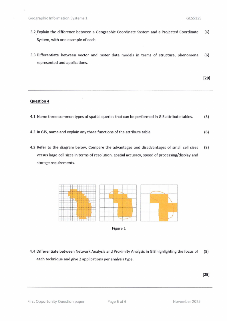
4.3 Refer to the diagram below. Compare the advantages and disadvantages of small cell sizes (8)
versus large cell sizes in terms of resolution, spatial accuracy, speed of processing/display and
storage requirements.
III II I
II II I
II
l~ l'--"lt-t--1--+-->-+--i
f-- - - •• - • !-·.--r-+--,---,----,
,.... -t-,.:;. • • : : . . .~ L~
1--H!--H-+-+_ , . . . . ~ 1-
1--1-t-+-t-t- r- ,- . . . . . f--
1--Hrl-l-+-+-H- : : : : : ii=
~ T t--t-+-++--+-<--Hi :
:::
: I '-1 •• Cf' 1
I
I
Figure 1
4.4 Differentiate between Network Analysis and Proximity Analysis in GIS highlighting the focus of (8)
each technique and give 2 applications per analysis type.
[25]
First Opportunity Question paper
Page 5 of 6
November 2025
|
|
6 Page 6 |
▲back to top |
Geographic Information Systems 1
Question 5
GES512S
The Ministry of Lands wants to produce maps for different purposes:
i) A detailed cadastral map of plots in Katutura
ii) A regional land use planning map for Erongo Region
iii) A national overview map of Namibia's vegetation zones
5.1 Identify the most appropriate scale for each map.
(3)
5.2 State four factors that influence the choice of scale when designing these maps.
(4)
5.3 List the 5 map elements that are typically present on a map.
(5)
5.4 Explain the concept of map generalisation and discuss any two techniques used in the process. (6)
For each technique, provide a suitable example of where it would be applied in Namibia.
5.5 Discuss the importance of map projections in cartography and GIS. Give examples of projection (7)
types appropriate to Namibia.
[25]
First Opportunity Question paper
Page 6 of 6
November 2025