


 |
GRS811S - GIS AND REMOTED SENSING IN PRACTICE - 2ND OPP - JULY 2023 |
|
|
1 Page 1 |
▲back to top |
n Am I BI A 'Un IVER s I TY
OF SCIEnCE RnD TECHnOLOGY
FACULTY OF HEALTH, NATURAL RESOURCES AND APPLIED SCIENCES
SCHOOL OF AGRICULTURE AND NATURAL RESOURCE SCIENCES
DEPARTMENT OF NATURAL RESOURCE SCIENCES
QUALIFICATION: BACHELOR OF NATURAL RESOURCE MANAGEMENT HONOURS
QUALIFICATION CODE: 09MNRM
LEVEL: 8
COURSE CODE: GRS811S
COURSE NAME: GIS AND REMOTE SENSING IN
PRACTICE
DATE: JULY 2023
DURATION: 3 HOURS
MARKS: 84
SECOND OPPORTUNITY EXAMINATION QUESTION PAPER
EXAMINER(S) Prof. Vera De Cauwer
MODERATOR: Ms. Foibe Nelao Johannes
INSTRUCTIONS
1. Number your answers clearly.
2. Show your detailed working for each calculation.
PERMISSIBLE MATERIALS
1. Calculator
THIS QUESTION PAPER CONSISTS OF 2 PAGES (Excluding this front page)
|
|
2 Page 2 |
▲back to top |
Question 1
[8]
a) What is the difference between vector and raster data?
b) Give an example of a vector file and a raster file.
Question 2
[22)
Indicate if the following statements are True or False. If false, correct the statement.
1. Electromagnetic radiation with a long wavelength has a low frequency.
2. A satellite image contains geospatial information in vector format.
3. Longitude varies from 0° at Greenwich to 180° east or west.
4. Electromagnetic radiation travels at the speed of sound (343 m/s).
5. Satellite images record the light absorbed by objects.
6. It is advised to always use illumination from the southwest to display hill shades on a
map.
7. Coordinates of latitude represent the X-axisfor the grid of latitude and longitude lines
covering the world.
8. You can not open a QGISproject on a computer without having the GISdata used in
the project.
9. The latitude at the equator is 90°.
10. GPSdata is vector data and most often in gpx format.
11. UAV's are unmanned aerial vehicles that normally fly at lower altitudes than
aeroplanes.
12. If you double-click a shape file in file explorer, it will not open.
13. An isohyet is a line that joins points of equal elevation.
14. Sentinel is a satellite sensor collecting multispectral data at low resolution.
Question 3
[5]
What is a GISmetadata file? Give three types of information that can be stored in such a
file.
Question 4
[SJ
What is the difference between active and passive remote sensing sensors? Give one
example of both.
Question 5
[10)
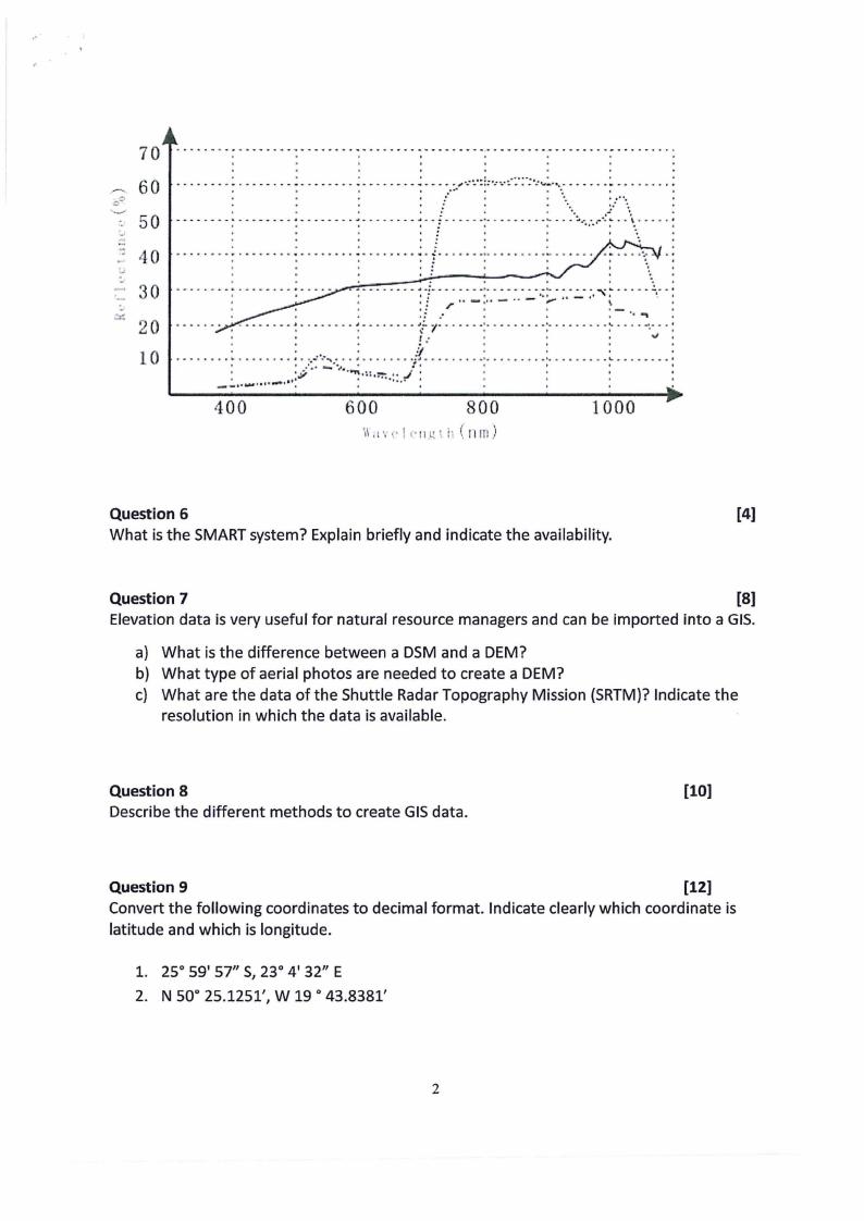
The following figure shows three different lines, each from a different land cover type.
1. What do you call the graph represented in the figure?
2. What land cover type does each of the three lines (full, ... dots, -..- dash-dot) in the
graph represent? Explain in detail why (for each line).
|
|
3 Page 3 |
▲back to top |
70
_,,...., 60
=,=·
··'·•_-,--50
·--- 40
-~
-
.-:-,--:: 30
20
10
..........................-
. . '
..........-
-
........-
........-
-
....-
......-
........-.
............-. ....
- ......- ..........-. -... - ....
..
. .I
•
I
'
.I
.I
I
'
.
. . . . . . .. - - .. - - .... : . - - - - .... : . - - .... - - .. ' - - - - - - .. - .. - ....,•-·4· '"'·:.•.·:'L··..--·-·:-..-:.:.·..:·.-..:..•...:........ ..... - ...... :
•
o
:
I
•
••
i ,•••
•
t
I
,•
•
•
•,
~•:
...
- --- -----: ..---..-- -: -------.. - . ------ --f - .----:----..--. -~--:-~..~-..-.-: .. \\.,. ....:
:f
-.................................................... .:.....................
·-. . .... .
\\
........-._.
...
•!
•
.
•
.-......-..-..-:....-.
.!
.:....-.- t.
.;
:: :.!-:_.:-:.:.:.-=:::._: ;·,...i .-..
--.
!,-
.
•:
..
.
.
.; .·
:--.-~ .
..- ..- . . .. . .... - - - - - ...... - - - .. - . - - - ..- - ~~1:.·. - ... - - ·:· ..- ..- - - . -:·-. - - - ..- ... - .... --.-... :
.
•.
•.
.-l ..
•.
.•
''
._, ''
·--·-· L~.:.~~.:.).l:·~-:·,·:·)··~··,·;:,··;·_-···:·=:··-·.·/··1···-·--···:
400
600
800
',\\ •1\\ i • I P 11l! , !· ( rI rn)
1000
Question 6
[4)
What is the SMARTsystem? Explain briefly and indicate the availability.
Question 7
[8]
Elevation data is very useful for natural resource managers and can be imported into a GIS.
a) What is the difference between a DSM and a DEM?
b) What type of aerial photos are needed to create a DEM?
c) What are the data of the Shuttle Radar Topography Mission (SRTM)?Indicate the
resolution in which the data is available.
Question 8
[10)
Describe the different methods to create GISdata.
Question 9
[12)
Convert the following coordinates to decimal format. Indicate clearly which coordinate is
latitude and which is longitude.
1. 25° 59' 57" S, 23° 4' 32" E
2. N 50° 25.1251', W 19 ° 43.8381'
2