


 |
GMN621S - GEOINFORMATION MANAGEMENT - 2ND OPP - JAN 2020 |
|
|
1 Page 1 |
▲back to top |
NAMIBIA UNIVERSITY
OF SCIENCE AND TECHNOLOGY
FACULTY OF NATURAL RESOURCES AND SPATIAL SCIENCES
DEPARTMENT OF GEO-SPATIAL SCIENCES AND TECHNOLOGY
QUALIFICATION:
BACHELOR OF GEOINFORMATION TECHNOLOGY
BACHELOR OF LAND ADMINISTRATION
QUALIFICATION CODE:
LEVEL: 6
07GITB
07BLAD
COURSE CODE: GMN621S
COURSE NAME: GEOINFORMATION MANAGEMENT
SESSION:
JANUARY 2020
PAPER:
THEORY
DURATION:
3 HOURS
MARKS:
100
SECOND OPPORTUNITY/SUPPLEMENTARY EXAMINATION QUESTION PAPER
EXAMINER(S)
DR LAMECK MWEWA
MODERATOR:
DR THOMAS CHRISTIANSEN
INSTRUCTIONS
Fill in the exam sheet. Write your student number on each answer
sheet used.
This exam paper has five questions. Answer ALL the questions.
Read each question carefully before attempting to answer.
Write clearly and neatly.
PERMISSIBLE MATERIALS
1. Non-programmable Calculator
2. Ruler, Pen, Pencil, Eraser (rubber), Standard Normal Distribution Tables
(attached)
THIS QUESTION PAPER CONSISTS OF (5) PAGES (Excluding this front page)
|
|
2 Page 2 |
▲back to top |
Geoinformation Management
Question 1: GIS Implementation
GMN621S
The establishment of a GIS is a complex process which needs careful planning, based on a thorough
analysis of the respective institution and its requirements. This is influenced by the type, purpose
and level of GIS implementation.
1.1. Give four reasons why proper planning of GIS is needed.
(4)
1.2. List four main types of GIS implementation levels in an organisation. For each, explain what
reasons could trigger the “Thinking about Implementing a GIS” at that level.
(8)
1.3. The GIS planning and implementation methodology can be subdivided into four main phases
and nine planning stages. Name and briefly explain the four phases.
(8)
[20]
Question 2: GIS Project Planning and tools
2.1. If you are hired as a consultant to implement a multi-user GIS for a very large organisation. List
six main GIS aspects (or components) that you will need to consider in the planning process. _— (6)
2.2. The Logical Framework is an approach to project planning that was developed as a tool for
detailed planning with clearly defined objectives that can be measured by using appropriate
indicators. List the ten steps in the development of a logical framework in their correct logical
sequence. (no explanations please).
(10)
2.3. Draw a blank logical framework template (use any style that is commonly used).
(4)
[20]
Second Opportunity/Supplementary Exam
Page 1of5
January 2020
|
|
3 Page 3 |
▲back to top |
Geoinformation Management
GMN621S
Question 3: GIS Data Characteristics and Quality Aspects
The quality of an GIS analysis depends on the quality of data and the skills of the person doing the
analysis. One of the characteristics of data that needs to be managed is errors.
3.1. What is the difference between accuracy and precision of spatial data? Use a simple
diagram or example to support your answer.
(4)
3.2. One of the aspects to consider when choosing remote sensing imagery as primary a primary
data source is the four image resolutions. Discuss briefly the importance of knowing each of the
resolutions in relation to amount and quality of the data.
(8)
3.3. You are a consultant hired to collect data for a GIS to produce urban development
monitoring maps.
a) Assuming you have to produce a map for a town planning firm. What would be the scale
of the map if a 20m x 40 m erf is 10mm x 20mm on the map?
(2)
b) Now that you have determine the scale of your map, what would be the perimeter in cm
of a school sports field area on the map if the perimeter on the ground is 400m?
(3)
c) Assume a person offers you a 3.6 Ha plot to buy and then shows you the location of the
plot on a map with same scale as in (a). The plot which he shows you is a rectangular
polygon and measures 8 cm x 10 cm on the map. By how much bigger or smaller (in ha)
is this plot on the ground?
(3)
[20]
Second Opportunity/Supplementary Exam
Page 2 of5
January 2020
|
|
4 Page 4 |
▲back to top |
Geoinformation Management
GMN621S
Question 4: Spatial Data Infrastructure (SDI)
Namibia is busy implementing a National Spatial Data Infrastructure (NSDI) Policy and the Namibia
Statistics Agency (NSA) is mandated by the Statistics Act, No. 9 of 2011 to implement this.
4.1. Define what you understand by spatial data infrastructure (SDI) and name two types. (4)
4.2. State and describe briefly the two categories/classes of spatial data that one finds in the
National Spatial Data Infrastructure in Namibia. Give one example of each type.
(8)
4.3. Outline the relevance/importance issues of implementing of the NSDI in Namibia.
(8)
[20]
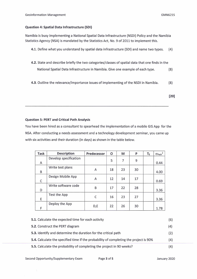
Question 5: PERT and Critical Path Analysis
You have been hired as a consultant to spearhead the implementation ofa mobile GIS App for the
NSA. After conducting a needs assessment and a technology development seminar, you came up
with six activities and their duration (in days) as shown in the table below.
Task
Description
Predecessor | O
M
Develop specification
5
A
5
Write test plans
A
18
23
C
Design Mobile App
A
12,
14
Write software code
D
B
17
22
E
Test the App
C
16
23
Fc
Deploy the App
D,E
22
26
P
Te | Gpath?
9
0.44
30
4.00
17
0.69
28
3.36
27
3.36
30
1.78
5.1. Calculate the expected time for each activity
(6)
5.2. Construct the PERT diagram
(4)
5.3. Identify and determine the duration for the critical path
(2)
5.4. Calculate the specified time if the probability of completing the project is 90%
(4)
5.5. Calculate the probability of completing the project in 90 weeks?
(4)
Second Opportunity/Supplementary Exam
Page 3 of 5
January 2020
|
|
5 Page 5 |
▲back to top |
Geoinformation Management
.
GMN621S
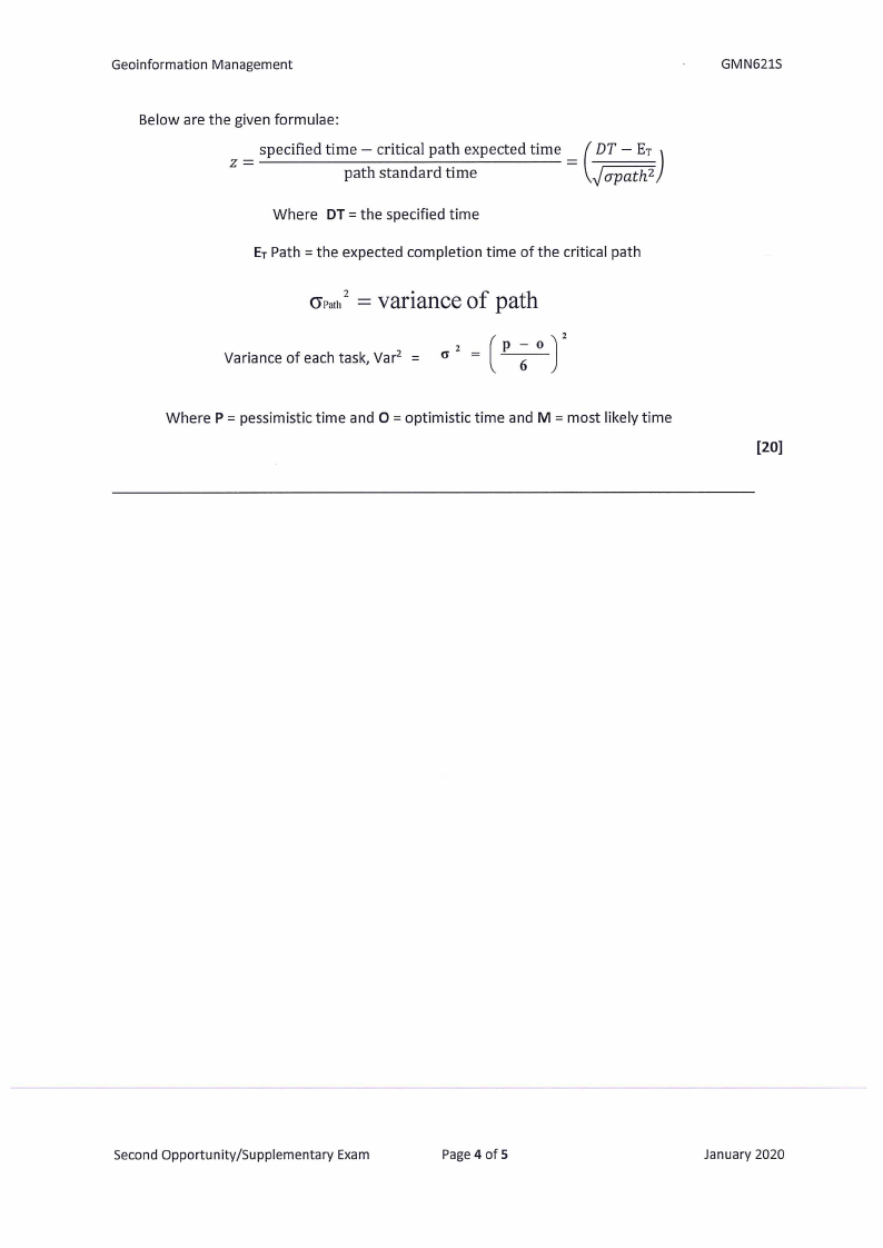
Below are the given formulae:
_ specified time — critical path expected time _ ( DT — Er }
a
path standard time
7 f opath?
Where DT =the specified time
E; Path = the expected completion time of the critical path
Oran = Variance of path
2
Variance of each task, Var? = o* = ( P
Where P = pessimistic time and O = optimistic time and M = most likely time
[20]
Second Opportunity/Supplementary Exam
Page 4 of 5
January 2020
|
|
6 Page 6 |
▲back to top |
Geoinformation Management
GMN621S
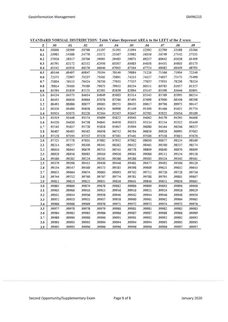
STANDARD NORMAL DISTRIBUTION: Table Values Represent AREA to the LEFT of the Z score.
Zz
00
-01
02
.03
04
-05
06
-07
-08
-09
0.0 | .50000
0.1 53983
-50399
-54380
50798
-54776
-51197
-55172
-51595
-55567
51994
55962
52392
56356
52790
56749
53188
57142
53586
87535
0.2 | .57926
0.3 | .61791
-58317
-62172
-58706
-62552
59095
-62930
59483
.63307
59871
-63683
-60257
-64058
-60642
64431
-61026
64803
-61409
-65173
0.4 -65542
-65910
-66276
-66640
-67003
-67364
-67724
-68082
-68439
-68793
0.5
0.6 |
0.7 |
-69146
.72575
.75804
-69497
-72907
-76115
-69847
-13237
-76424
-70194
-73565
.76730
-70540
-73891
-77035
-70884
74215
17337
-71226
-74537
-77637
-71566
74857
17935
-71904
s15175
-78230
.72240
-75490
-78524
0.8 | .78814
-79103
-79389
.19673
-79955
-80234
-80511
.80785
81057
-81327
0.9
1.0 |
1.1 |
1.2 |
-81594
.84134
.86433
.88493
-81859
-84375
-86650
88686
-82121
84614
86864
-88877
-82381
-84849
87076
89065
82639
-85083
-87286
89251
-82894
85314
87493
89435
-83147
-85543
-87698
-89617
.83398
85769
87900
89796
83646
-85993
-88100
89973
-83891
-86214
-88298
-90147
1.3
1.4 |
1.5 |
-90320
.91924
.93319
-90490
92073
-93448
-90658
-92220
-93574
-90824
92364
-93699
90988
92507
93822
-91149
92647
-93943
-91309
292785
94062
91466
92922
94179
91621
93056
-94295
91774
-93189
-94408
1.6
1.7 |
1.8 |
-94520
95543
.96407
-94630
-95637
-96485
94738
-95728
-96562
94845
95818
-96638
94950
95907
96712
95053
95994
96784
95154
-96080
96856
95254
.96164
96926
-95352
-96246
96995
95449
96327
97062
1.9 |
2.0 |
2.1 |
.97128
.97725
.98214
-97193
-97778
-98257
-97257
-97831
-98300
-97320
-97882
-98341
-97381
97932
98382
97441
97982
-98422
-97500
98030
98461
97558
-98077
98500
97615
98124
98537
97670
-98169
98574
2.2 | .98610
2.3 | .98928
-98645
-98956
-98679
-98983
-98713
-99010
98745
99036
-98778
99061
-98809
-99086
-98840
99111
98870
-99134
-98899
99158
2.4 | .99180
-99202 -99224
99245
99266
99286
99305
99324
-99343
99361
2.5 -99379
2.6 | .99534
-99396
-99547
-99413
-99560
99430
99573
99446
99585
99461
99598
99477
99609
99492
99621
99506
99632
-99520
-99643
2.7 | .99653
-99664
-99674
-99683
99693
-99702
99711
99720
99728
-99736
2.8
2.9 |
3.0 |
3.1 |
-99744
.99813
.99865
.99903
-99752
-99819
-99869
-99906
-99760
-99825
-99874
-99910
-99767
-99831
99878
99913
.99774
99836
99882
99916
-99781
99841
-99886
99918
99788
99846
-99889
-99921
99795
99851
99893
99924
-99801
99856
99896
99926
-99807
99861
-99900
99929
3.2
3.3 |
3.4 |
-99931
.99952
.99966
-99934
-99953
-99968
-99936
99955
-99969
-99938
-99957
-99970
99940
99958
99971
-99942
99960
99972
99944
99961
99973
-99946
99962
99974
-99948
99964
99975
-99950
-99965
39976
3.5 | .99977
3.6 | .99984
-99978
-99985
99978
-99985
99979
-99986
99980
99986
99981
99987
99981
99987
99982
99988
99983
99988
99983
99989
3.7 | .99989
3.8 | .99993
-99990
-99993
-99990
-99993
99990
99994
99991
99994
-99991
99994
99992
99994
99992
99995
-99992
-99995
-99992
-99995
3.9 | .99995
-99995
-99996
-99996
99996
99996
99996
99996
99997
99997
Second Opportunity/Supplementary Exam
Page 5 of 5
January 2020