ISM520S - INTRODUCTION TO SURVEY MAPPING - 1ST OPP - NOV 2024


ISM520S - INTRODUCTION TO SURVEY MAPPING - 1ST OPP - NOV 2024


1 Page 1

▲back to top


nAmlBIA UnlVERSITY
OF SCIEnCE Ano TECHnOLOGY
FACULTYOF ENGINEERINGAND THE BUILTENVIRONMENT
DEPARTMENTOF LANDAND SPATIALSCIENCES
QUALIFICATION: BACHELOR OF QUANTITY SURVEYING, BACHELOR OF GEOINFORMATION TECHNOLOGY,
BACHELOROF LAND ADMINISTRATION, BACHELOROF ARCHITECTURE, BACHE~OROF REGIONAL AND
URBAN PLANNING, BACHELOR OF REGIONAL AND RURAL DEVELOPMENT
QUALIFICATION CODE: 07BQOS, 07BGEI,
07BLAM, 07BARC, 07BURP, 07BROR
LEVEL: 5
COURSE: INTRODUCTION TO
SURVEYAND MAPPING
COURSECODE: ISM520S
SESSION: NOVEMBER 2024
PAPER:
THEORY
DURATION: 3 HOURS
MARKS:
100
FIRSTOPPORTUNITYEXAMINATION QUESTION PAPER
EXAMINERS: Ms D. Husselmann and Mr D. Varges
MODERATOR: Mr S. Sinvula
THIS QUESTION PAPERCONSISTSOF 10 PAGES(Including this front page)
INSTRUCTIONS
1. Answer ALL the questions.
2. Write clearly and neatly.
3. Number the answers clearly.
4. Answers to calculations must be rounded off to three decimal places, excluding
answers to co-ordinate conversions
PERMISSIBLEMATERIALS
1. Calculators and other drawing equipment

2 Page 2

▲back to top


Introduction to Survey and Mapping
ISM520S
Question 1
Answer the following questions by selecting the correct statement for each:
(10)
1.1.
The position of a point may be determined by a variety of methods. Which of these
methods uses distances to determing the position of a point?
a. Triangulation
b. Trilateration
c. Polar
d. Traverses
1.2.
Which of the following instruments are used to determine the hieghts of points
accurately?
a. Level
b. Measuring tape
c. Theodolite
d. Total station
1.3.
Which of thse levels read a bar-coded staff using electronic laser methods?
a. Dumpy level
b. Automatic level
c. Tilting level
d. Digital level
1.4.
For the Namibian LO co-ordinate system:
a. Any of the Y or X co-ordinate can be written first
b. It is convention that X is written first and Y second
c. It is convention that Y is written first and X second
d. This co-ordinate system does not use Y and X co-ordinates
1.5.
One of these corrections are applied only to taped distances:
a. Scale enlargement
b. Reduction to mean sea level
c. Converstion to German legal Meter
d. Standard Temperature
First Opportunity Question Paper
Page 2 of 10
November 2024

3 Page 3

▲back to top


Introduction to Survey and Mapping
ISM520S
1.6.
Which of these is a method used to determine the horizontal distance and horizontal
angle?
a. Polar
b. Join
c. Traverses
d. Trilateration
1.7.
A traverse that ends at an unknown point is known as a:
a. Link traverst
b. Loop traverse
c. Open traverse
d. Closed traverse
1.8.
Which of these describes setting out?
a. Transferring positional values from plans to the ground
b. Transferring positional values from ground to plans
c. Determining positional values using survey software
d. Comparing measured and calculated values
1.9.
DGPSstands for:
a. Distance Global Positioning System
b. Differential Geographic Positioning System
c. Distance Geographic Positioning System
d. Differential Global Positioning System
1.10. The picture below represents which natural feature?
a. Ridge
b. Valley
c. Vertical cliff
d. Pond
First Opportunity Question Paper
Page 3 of 10
November 2024

4 Page 4

▲back to top


Introduction to Survey and Mapping
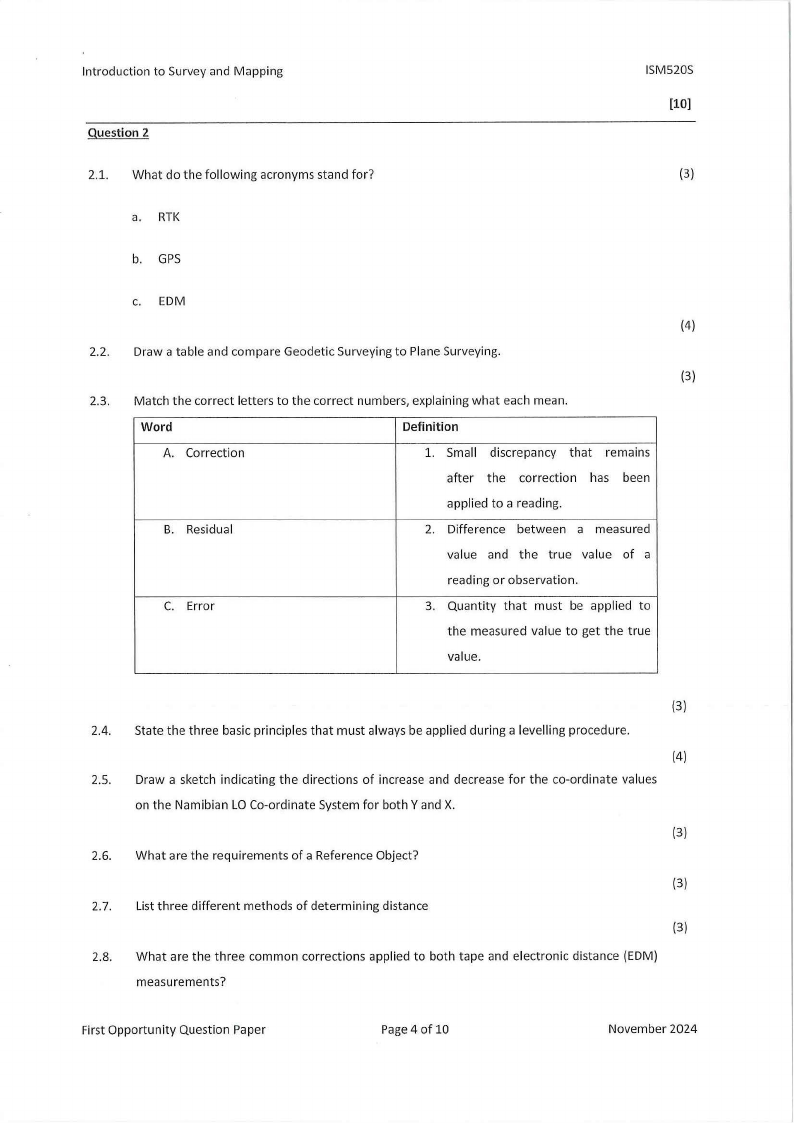
Question 2
ISM520S
(10)
2.1. What do the following acronyms stand for?
(3)
a. RTK
b. GPS
c. EOM
(4)
2.2. Draw a table and compare Geodetic Surveying to Plane Surveying.
(3)
2.3. Match the correct letters to the correct numbers, explaining what each mean.
Word
Definition
A. Correction
1. Small discrepancy that remains
after the correction has been
applied to a reading.
B. Residual
2. Difference between a measured
value and the true value of a
reading or observation.
C. Error
3. Quantity that must be applied to
the measured value to get the true
value.
(3)
2.4. State the three basic principles that must always be applied during a levelling procedure.
(4)
2.5. Draw a sketch indicating the directions of increase and decrease for the co-ordinate values
on the Namibian LO Co-ordinate System for both Y and X.
(3)
2.6. What are the requirements of a Reference Object?
(3)
2.7. List three different methods of determining distance
(3)
2.8. What are the three common corrections applied to both tape and electronic distance (EDM)
measurements?
First Opportunity Question Paper
Page4 of 10
November 2024

5 Page 5

▲back to top


Introduction to Survey and Mapping
ISM520S
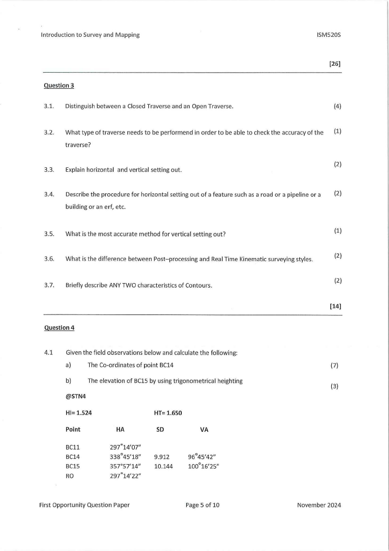
Question 3
3.1. Distinguish between a Closed Traverse and an Open Traverse.
(26]
(4)
3.2. What type of traverse needs to be performend in order to be able to check the accuracy of the (1)
traverse?
(2)
3.3. Explain horizontal and vertical setting out.
3.4. Describe the procedure for horizontal setting out of a feature such as a road or a pipeline or a (2)
building or an erf, etc.
3.5. What is the most accurate method for vertical setting out?
(1)
3.6. What is the difference between Post-processing and Real Time Kinematic surveying styles.
(2)
(2)
3.7. Briefly describe ANY TWO characteristics of Contours.
[14]
Question 4
4.1 Given the field observations below and calculate the following:
a)
The Co-ordinates of point BC14
{7)
b)
The elevation of BC15 by using trigonometrical heighting
(3)
@STN4
HI= 1.524
Point
HA
HT= 1.650
SD
VA
BC11
BC14
BC15
RO
297°14'07"
338°45'18"
357°57'14"
297°14'22"
9.912
10.144
96°45'42"
100°16'25"
First Opportunity Question Paper
Page 5 of 10
November 2024

6 Page 6

▲back to top


Introduction to Survey and Mapping
ISM520S
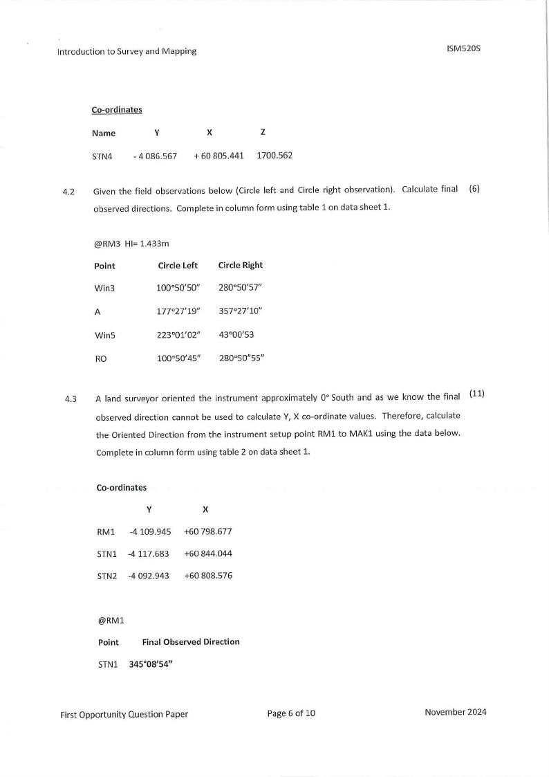
Co-ordinates
Name
V
STN4 - 4 086.567
X
Z
+ 60 805.441 1700.562
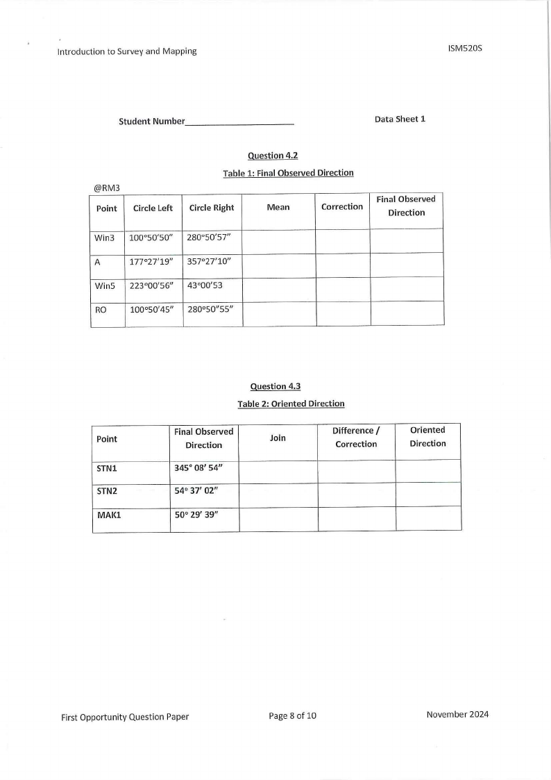
4.2 Given the field observations below (Circle left and Circle right observation). Calculate final (6)
observed directions. Complete in column form using table 1 on data sheet 1.
@RM3 HI= 1.433m
Point
Circle Left
Win3
100°50'50"
A
177°27'19"
Wins
223°01'02"
RO
100°50'45"
Circle Right
280°50'57"
357°27'10"
43°00'53
280°50"55"
4.3 A land surveyor oriented the instrument approximately o•South and as we know the final (ll)
observed direction cannot be used to calculate V, X co-ordinate values. Therefore, calculate
the Oriented Direction from the instrument setup point RMl to MAKl using the data below.
Complete in column form using table 2 on data sheet 1.
Co-ordinates
V
X
RMl -4 109.945 +60 798.677
STNl -4117.683 +60 844.044
STN2 -4 092.943 +60 808.576
@RMl
Point
Final Observed Direction
STNl 345°08'54"
First Opportunity Question Paper
Page 6 of 10
November 2024

7 Page 7

▲back to top


Introduction to Survey and Mapping
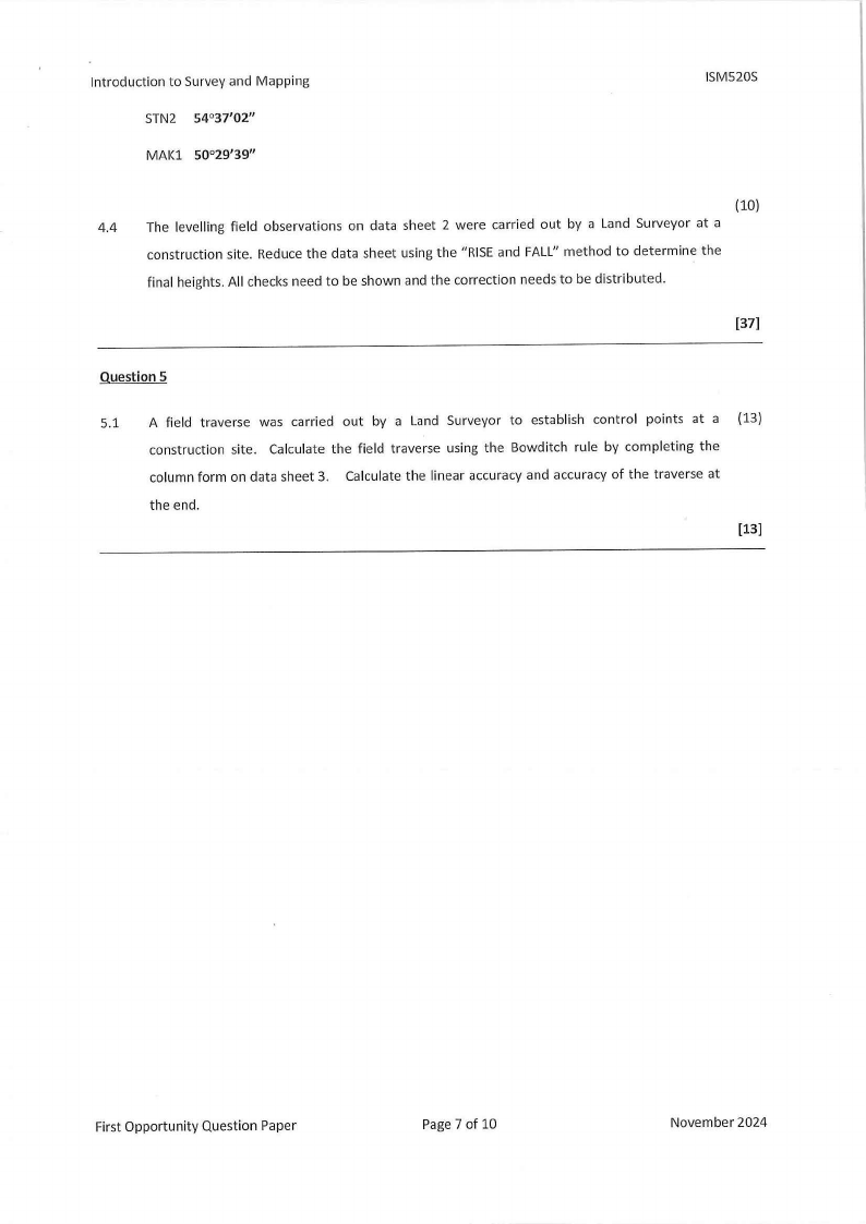
STN2 54°37'02"
MAKl 50°29'39"
ISM520S
(10)
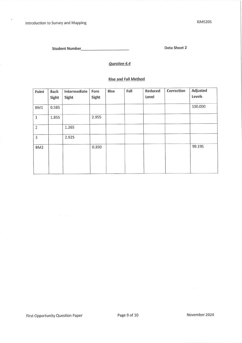
4.4 The levelling field observations on data sheet 2 were carried out by a Land Surveyor at a
construction site. Reduce the data sheet using the "RISEand FALL" method to determine the
final heights. All checks need to be shown and the correction needs to be distributed.
(37)
Question 5
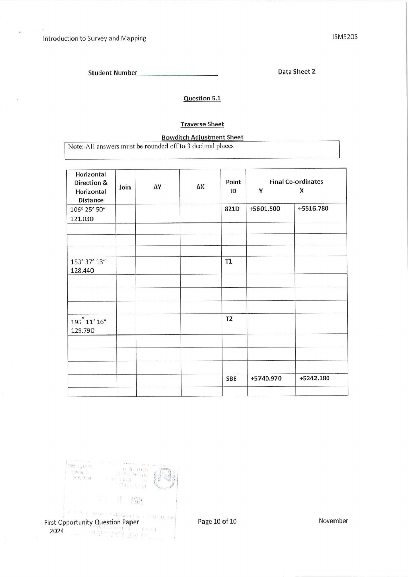
5.1 A field traverse was carried out by a Land Surveyor to establish control points at a (13)
construction site. Calculate the field traverse using the Bowditch rule by completing the
column form on data sheet 3. Calculate the linear accuracy and accuracy of the traverse at
the end.
First Opportunity Question Paper
Page 7 of 10
November 2024

8 Page 8

▲back to top


Introduction to Survey and Mapping
ISM520S
Student Number _________
_
Data Sheet 1
@RM3
Point Circle Left
Question 4.2
Table 1: Final Observed Direction
Circle Right
Mean
Correction
Final Observed
Direction
Win3 100°50'50" 280°50' 57"
A
177°27'19" 357°27'10"
Win5 223°00'56" 43°00'53
RO
100°50'45" 280°50"55"
Point
STNl
STN2
MAl(l
Question 4.3
Table 2: Oriented Direction
Final Observed
Direction
345° 08' 54"
54° 37' 02"
50° 29' 39"
Join
Difference /
Correction
Oriented
Direction
First Opportunity Question Paper
Page 8 of 10
November 2024

9 Page 9

▲back to top


Introduction to Survey and Mapping
ISM520S
Student Number _________
_
Data Sheet 2
Question 4.4
Rise and Fall Method
Point Back Intermediate Fore Rise
Fall
Sight Sight
Sight
BM1 0.585
1
1.855
2.955
2
1.265
3
2.925
BM2
0.350
Reduced Correction Adjusted
Level
Levels
100.000
99.195
First Opportunity Question Paper
Page 9 of 10
November 2024

10 Page 10

▲back to top


Introduction to Survey and Mapping
ISM520S
Student Number _________
_
Question 5.1
Traverse Sheet
Bowditch Adjustment Sheet
Note: All answers must be rounded off to 3 decimal places
Data Sheet 2
Horizontal
Direction &
Horizontal
Join
8.Y
Distance
106° 25' 50"
121.030
8.X
Point
ID
Final Co-ordinates
y
X
821D +5601.500
+5516.780
153° 37' 13"
Tl
128.440
0
195 11' 16"
T2
129.790
SBE +5740.970
+5242.180
I \\ ti lj
I,., Id
,. i,
(.
First Opportunity Question Paper
2024
Page 10 of 10
November