


 |
ODC721S - GEODESY - 1ST OPP - NOV 2025 |
|
|
1 Page 1 |
▲back to top |
n Am I BI A u n IVER s ITY
OF SC IEnCE A n □ TECH n OLOGY
FACULTY OF ENGINEERING AND THE BUILT ENVIRONMENT
DEPARTMENT OF LANO ANO SPATIAL SCIENCES
QUALIFICATIONS:
BACHEtOWOF-GEOMATIC::>
QUALIFICATIONS CODES:
07BGEO
COURSE CODE: ODC721S
DATE: November 2025
DURATION: 3 HOURS
-
--
QUALIFICATION LEVEL:
Level 7 - 07BGEO
COURSE NAME: Geodesy
PAPER:THEORY
MARKS: 100
EXAMINER:
MODERATOR:
FIRST OPPORTUNITY EXAMINATION QUESTION PAPER
Dr J. Odumosu
Dr K. Owolabi
INSTRUCTIONS
1. Answer all questions.
2. Write clearly and neatly.
3. Marks will be deducted for poor writing, spelling and grammatical errors.
4. Number the answers clearly.
5. Make sure your Student Number is on the EXAMINATION BOOK{s) .
THIS- QUESTION PAPER CONSISTS OF 5 PAGES {Including this front page)
PERMISSIBLE MATERIAL
Calculator
|
|
2 Page 2 |
▲back to top |

Geodesy
ODC721S
QUESTION 1
1.1 The terrestrial coordinate system is an essential mapping frame for representing point
positions on Earth . Discuss this in the light of its various realizations.
(10)
1.2 The curvilinear coordinates of a point in Windhoek are as given below. Compute the ECEF
coordinates of the point.
(10)
Given that;
<p = -22.56°, ,1 = 17.065°, h = 1650m.
= em r-maJor axis: a 6378T3 . m
Flattening: f = 1/ 298.257223563
= Eccentricity squared: e2 2j - f 2 ~ 0.00669437999014
Hint:
X = (N + h) cos <p COSA.
Y = (N + h) cos <p sin,1
Z = [N (1 - e2) + h] sin <p
a
N=
(1-e
2
sin2
1
<p) /2
[20]
QUESTION 2
2.1 Discuss the application of Geodesy to:
(10)
(i)
Drought surveillance.
(ii) Earthquake monitoring & plate tectonics assessment.
2.2 Using relevant diagrams, define the following Geodetic terminologies:
(10)
(i)
Geodetic latitude.
- (ii) - - Parametric latitude~ - - - - - - - - - - - - - - - - - - - - - - - -
(iii) Geocentric Latitude.
(iv) Astronomic Latitude.
(v) Vernal equinox
[20]
First Opportun ity Question Paper
Page 2
November 2025
|
|
3 Page 3 |
▲back to top |
Geodesy
ODC721S
QUESTION 3
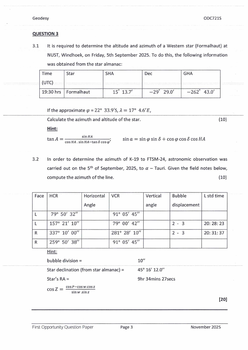
3.1 It is required to determine the altitude and azimuth of a Western star (Formalhaut) at
NUST, Windhoek, on Friday, 5th September 2025. To do this, the following information
was obtained from the star almanac:
Time
Star
SHA
Dec
GHA
(UTC) -
-
19:30 hrs Formalhaut
0
1s 13.7'
-29° 29.0'
-262° 43.0'
= If the approximate tp = 22° 33.9'5, ,1. 17° 4.6' E,
Calculate the azimuth and altitude of the star.
(10)
Hint:
tan A = - - - -sin-HA- - - ·
cos HA. sin HA-tan 8 cos <p'
sin a = sin tp sin 8 + cos tp cos 8 cos HA
3.2 In order to determine the azimuth of K-19 to FTSM-24, astronomic observation was
carried out on the 5th of September, 2025, to a - Tauri. Given the field notes below,
compute the azimuth of the line.
(10)
Face HCR
Horizontal VCR
Vertical
Bubble
L std time
Angle
angle
displacement
L
79° SO' 32"
91° OS' 45"
L
157° 21' 10"
79° 00' 42"
2- 3
20:28:23
R
337° 10' 00"
281° 28' 10"
2- 3
20:31:37
R
259° SO' 38"
91° OS' 45"
Hint:
bubble division=
- - - -------
Star declination (from star almanac)=
10"
----- ---
45° 16' 12.0"
--- - - - - -
Star's RA=
9hr 34mins 27secs
= cosZ
cos P-cos w .cos z
sin w .sinz
[20)
First Opportunity Question Paper
Page 3
November 2025
|
|
4 Page 4 |
▲back to top |

Geodesy
ODC721S
QUESTION 4
Given the following gravity observations taken with a Scrintrex CG5 gravimeter, compute the
following at each station:
4.1 Drift rate.
4.2 Latitude.
4.3 Free-air corrections.
Consequently, determine the final absolute gravity value for each station.
(20)
Table 1.1: Gravity field notes
Sta_lD Lat
Long Height
(<p)
(1)
(m)
YTl/24 6.5085 3.3751 28.20
GP0l 6.5143 3.3769 30.7
GP02 6.5251 3.3684 18.1
GP03 6.5298 3.3683 18.8
GP04 6.5251 3.3681 19.2
GP05 6.5185 3.3169 30.65
YTl/24 6.5085 3.3751 28.20
Dial
Reading
1580.8086
1581.7569
1582.9931
1582.2448
1582.3104
1581.6923
1580.8617
Time of
Observation
3/25/2017- 09:06
3/25/2017- 09:23
3/25/2017- 09:29
3/25/2017- 09:37
3/25/2017- 09:52
3/25/2017- 10:04
3/25/2017- 10:35
Absolute
Gravity (mga/s)
978119.857
Hints:
FAcorr = 0.3086h mgals
= Latcorr 0.000812 X sin(2<tJ) mgals/m
[20)
-------- ---------- ·--
First Opportunity Question Paper
Page 4
November 2025
|
|
5 Page 5 |
▲back to top |
Geodesy
ODC721S
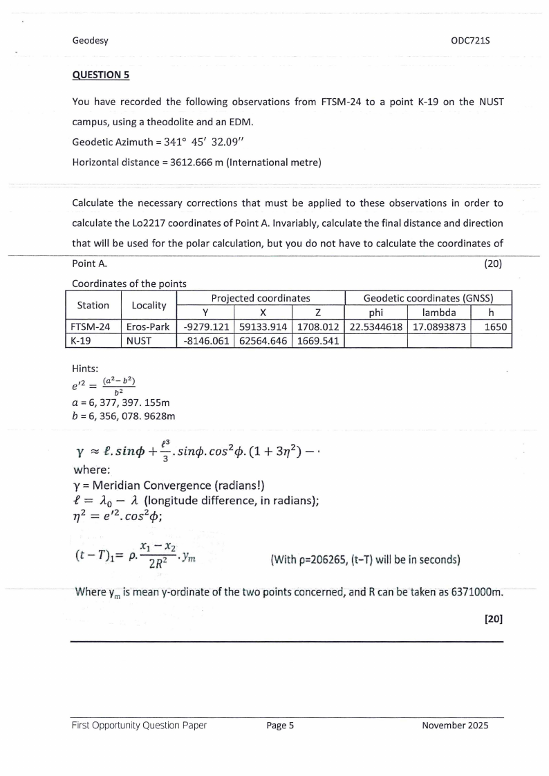
QUESTION 5
You have recorded the following observations from FTSM-24 to a point K-19 on the NUST
campus, using a theodolite and an EDM.
Geodetic Azimuth= 341° 45' 32.09"
Horizontal distance = 3612.666 m (International metre)
Calculate the necessary corrections that must be applied to these observations in order to
calculate the Lo2217 coordinates of Point A. Invariably, calculate the final distance and direction
that will be used for the polar calculation, but you do not have to calculate the coordinates of
Point A.
(20)
Coordinates of the points
Station Locality
Projected coordinates
y
X
z
FTSM -24 Eros-Park -9279.121 59133.914 1708.012
K-19
NUST
-8146.061 62564.646 1669.541
Geodetic coordinates (GNSS)
phi
lambda
h
22.5344618 17.0893873 1650
Hints:
= ,2 (a2 - b 2)
e
b2
a= 6, 377, 397. 155m
b = 6, 356, 078. 9628m
y ~ f . sin</J + e:. sin</). cos 2 <jJ. (1 + 3TJ2) - •
where:
y = Meridian Convergence (radians!)
= .f Ao - A (longitude difference, in radians);
= 7/ 2 e'2 . cos2¢;
(With p=206265, (t-T) will be in seconds)
[20]
First Opportunity Questi on Paper
Page 5
November 2025