ISM520S - INTRODUCTION TO SURVEY AND MAPPING - JAN 2025


ISM520S - INTRODUCTION TO SURVEY AND MAPPING - JAN 2025


1 Page 1

▲back to top


nAmlBIA unlVERSITY
OF SCIEnCE Ano TECHn OLOGY
FACULTYOF ENGINEERINGAND THE BUILTENVIRONMENT
DEPARTMENT OF LAND AND SPATIAL SCIENCES
QUALIFICATION: BACHELOR OF QUANTITY SURVEYING, BACHELOR OF GEOINFORMATION TECHNOLOGY,
BACHELOR OF LAND ADMINISTRATION, BACHELOR OF ARCHITECTURE, BACHELOR OF REGIONAL AND
URBAN PLANNING, BACHELOR OF REGIONAL AND RURAL DEVELOPMENT
QUALIFICATION CODE: 07BQOS, 07BGEI, LEVEL: 5
07BLAM, 07BARC, 07BURP, 07BROR
COURSE: INTRODUCTION TO
SURVEY AND MAPPING
COURSECODE: ISM5205
SESSION: JANUARY 2025
PAPER:
THEORY
DURATION: 3 HOURS
MARKS:
100
SECOND OPPORTUNITY/ SUPPLEMENTARY EXAMINATION QUESTION PAPER
EXAMINERS: Ms D. Husselmann and Mr D Varges
MODERATOR: Mr S. Sinvula
THIS QUESTION PAPERCONSISTSOF 9 PAGES(Including this front page)
INSTRUCTIONS
1. Answer ALL the questions.
2. Write clearly and neatly.
3. Number the answers clearly.
4. Answers to calculations must be rounded off to three decimal places, excluding
answers to co-ordinate conversions
PERMISSIBLEMATERIALS
1. Calculators and other drawing equipment

2 Page 2

▲back to top


Introduction to Survey and Mapping
Question 1
State whether the following are True or False.
ISM520S
(10)
1.1. Field work is the part of surveying when calculations and drawings are done in order
to prepare for observations to be done.
1.2. A theodolite and total station both measure distance and direction.
1.3. An automatic level only needs to be levelled approximately as it has a compensator
inside the level that makes it exactly levelled.
1.4. On the Namibian LO co-ordinate system, the false origin for Y is 22°S.
1.5. When applying more then the standard tension to taped distances, the measured
distance will be longer.
1.6. Polars and joins can be considered the inverse of each other as with one co-ordinates
are determined using distance and direction, and with the other distance and
direction are determined using co-ordinates.
1.7. A traverse should always start and end at the same known point.
1.8. Horizontal setting out is the process whereby the Y, X and Z values are marked on the
ground using values determined with the help of surveying software.
1.9. Differential GPS positioning technique is more accurate than autonomous GPS
positioning technique.
1.10. The contour interval on a map can differ depending on the landform being shown.
[10)
Second Opportunity Question Paper
Page 2 of 9
January 2025

3 Page 3

▲back to top


Introduction to Survey and Mapping
Question 2
ISM520S
2.1. What do the following acronyms stand for?
(3)
a. MSL
b. DOP
c. Glm
2.2. Differentiate between a map and a plan.
(2)
2.3. Match the correct letters to the correct numbers, defining each type of error.
(3)
Error
Definition
A. Systamtic Errors
1. Mistakes caused by negligence or
carelessness.
B. Random Errors
2. Errors occurring due to flaws in
instruments.
C. Gross Errors
3. Errors occurring due to limitations
of instruments.
2.4. Name 2 different methods used to determine the position of a point.
(2)
2.5. List three checks for blunders done during levelling calculation? (Write down the formulas) (3)
that should result in the same answer.
2.6. Draw and label the axes (orientation) of the Namibian LO coordinate system. Indicate the (4)
signs for both Y and X in each quadrant.
2.7. What are the purposes of a Reference Object (R/O)?
(3)
2.8. Explain why slope corrections must be applied to EDM measurements.
(3)
2.9. List three of the corrections applied to tape-measured distances.
(3)
Second Opportunity Question Paper
Page 3 of 9
(26]
January 2025

4 Page 4

▲back to top


Introduction to Survey and Mapping
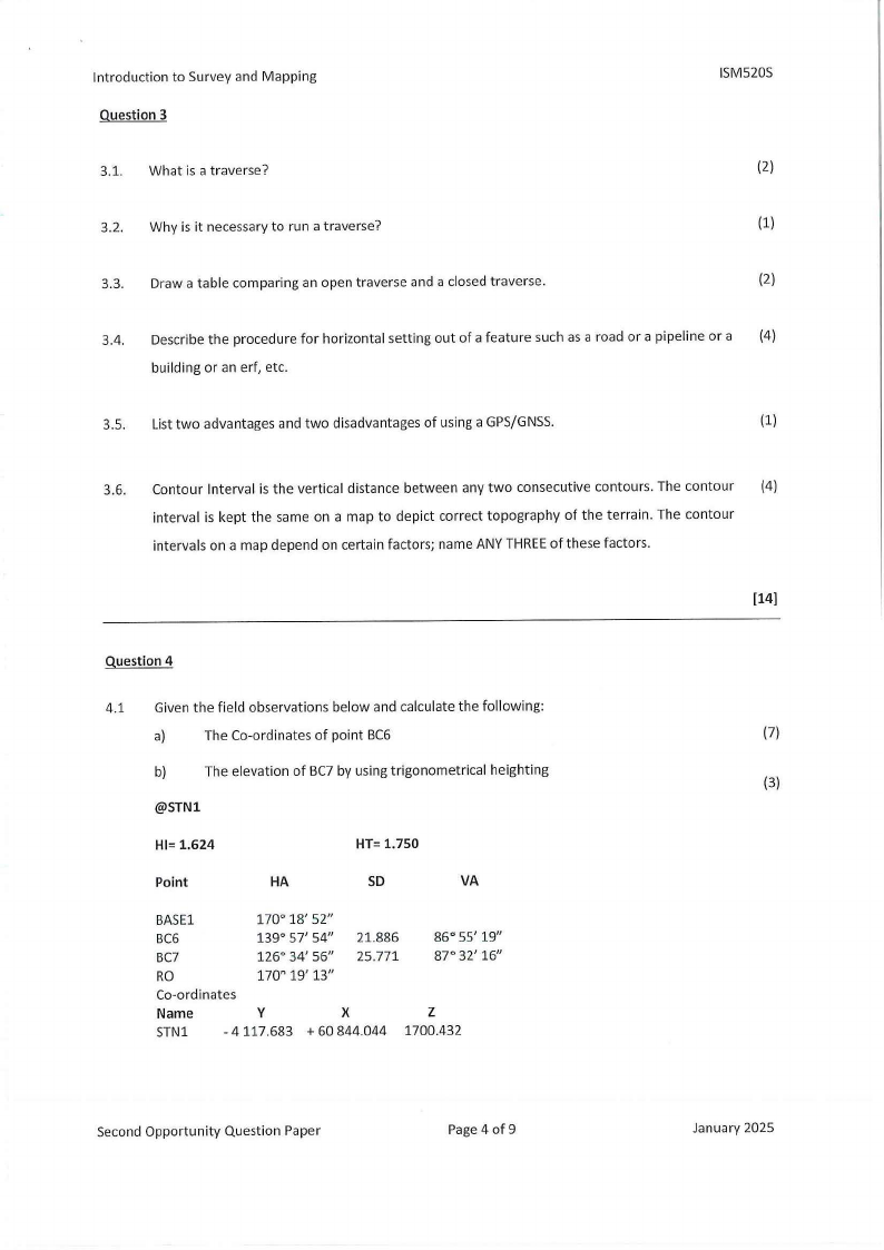
Question 3
ISM520S
3.1. What is a traverse?
(2)
3.2. Why is it necessary to run a traverse?
(1)
3.3. Draw a table comparing an open traverse and a closed traverse.
(2)
3.4. Describe the procedure for horizontal setting out of a feature such as a road or a pipeline or a (4)
building or an erf, etc.
3.5. List two advantages and two disadvantages of using a GPS/GNSS.
(1)
3.6. Contour Interval is the vertical distance between any two consecutive contours. The contour (4)
interval is kept the same on a map to depict correct topography of the terrain. The contour
intervals on a map depend on certain factors; name ANY THREEof these factors.
[14]
Question 4
4.1 Given the field observations below and calculate the following:
a)
The Co-ordinates of point BC6
(7)
b)
The elevation of BC7 by using trigonometrical heighting
(3)
@STNl
HI= 1.624
HT= 1.750
Point
HA
SD
VA
BASEl
170° 18' 52"
BC6
139° 57' 54" 21.886
86° 55' 19"
BC7
126° 34' 56" 25.771
87° 32' 16"
RO
170" 19' 13"
Co-ordinates
Name
y
X
z
STNl
- 4 117.683 + 60 844.044 1700.432
Second Opportunity Question Paper
Page 4 of 9
January 2025

5 Page 5

▲back to top


Introduction to Survey and Mapping
ISM520S
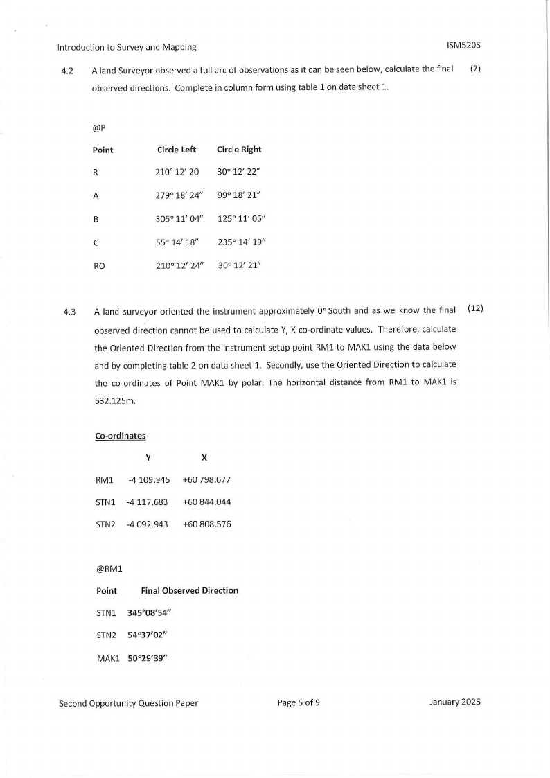
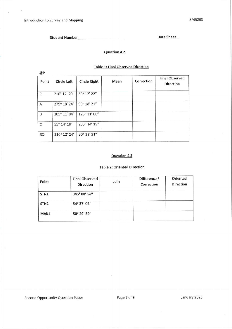
4.2 A land Surveyor observed a full arc of observations as it can be seen below, calculate the final (7)
observed directions. Complete in column form using table 1 on data sheet 1.
@P
Point
R
A
B
C
RO
Circle Left
Circle Right
210° 12' 20 30° 12' 22"
279° 18' 24" 99° 18' 21"
305° 11' 04" 125° 11' 06"
55° 14' 18" 235° 14' 19"
210° 12' 24" 30° 12' 21"
4.3 A land surveyor oriented the instrument approximately 0° South and as we know the final (12)
observed direction cannot be used to calculate Y, X co-ordinate values. Therefore, calculate
the Oriented Direction from the instrument setup point RM1 to MAK1 using the data below
and by completing table 2 on data sheet 1. Secondly, use the Oriented Direction to calculate
the co-ordinates of Point MAK1 by polar. The horizontal distance from RM1 to MAK1 is
532.125m.
Co-ordinates
y
X
RM1 -4109.945 +60 798.677
STN1 -4117.683 +60 844.044
STN2 -4 092.943 +60 808.576
@RM1
Point
Final Observed Direction
STN1 345°08'54"
STN2 54°37'02"
MAK1 50°29'39"
Second Opportunity Question Paper
Page 5 of 9
January 2025

6 Page 6

▲back to top


Introduction to Survey and Mapping
ISM520S
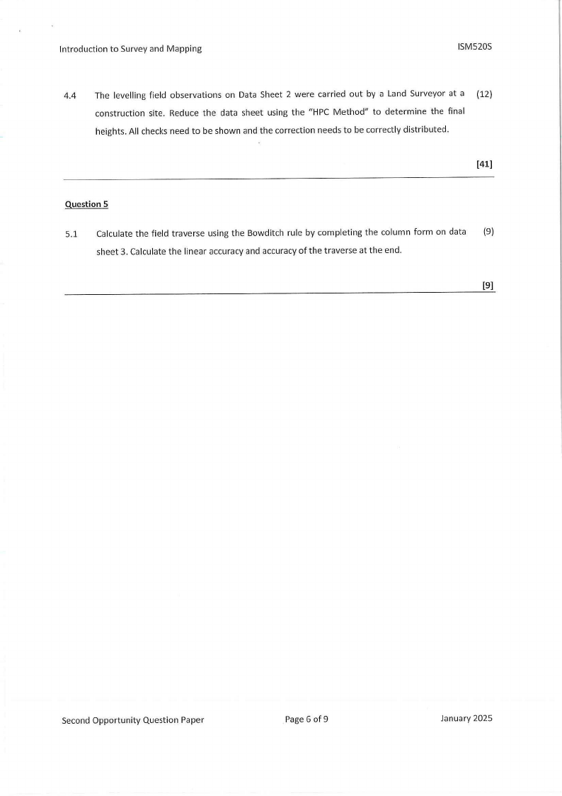
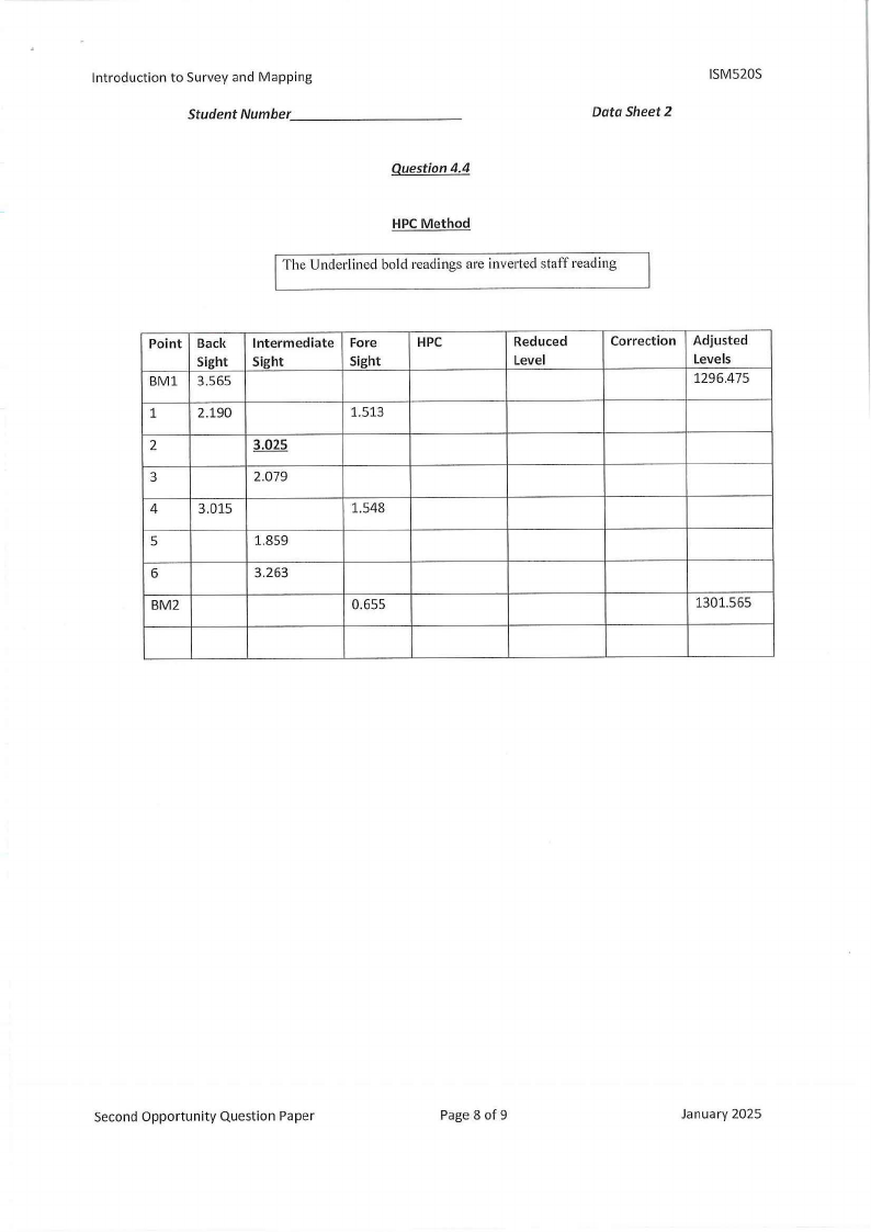
4.4 The levelling field observations on Data Sheet 2 were carried out by a Land Surveyor at a (12)
construction site. Reduce the data sheet using the "HPC Method" to determine the final
heights. Allchecks need to be shown and the correction needs to be correctly distributed.
(41]
Question 5
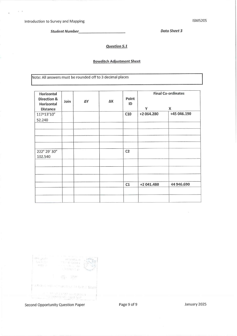
5.1 Calculate the field traverse using the Bowditch rule by completing the column form on data (9)
sheet 3. Calculate the linear accuracy and accuracy of the traverse at the end.
[9]
Second Opportunity Question Paper
Page 6 of9
January 2025

7 Page 7

▲back to top


Introduction to Survey and Mapping
ISM520S
Student Number _________
_
Data Sheet 1
Question 4.2
@P
Point
Circle Left
Table 1: Final Observed Direction
Circle Right
Mean
Correction
Final Observed
Direction
R
210° 12' 20 30° 12' 22"
A
279° 18' 24" 99° 18' 21"
B
305° 11' 04" 125° 11' 06"
C
55° 14' 18" 235° 14' 19"
RO
210° 12' 24" 30° 12' 21"
Point
STNl
STN2
MAl{l
Question 4.3
Table 2: Oriented Direction
Final Observed
Direction
Join
345° 08' 54"
54° 37' 02"
so·29' 39"
Difference /
Correction
Oriented
Direction
Second Opportunity Question Paper
Page 7 of 9
January 2025

8 Page 8

▲back to top


Introduction to Survey and Mapping
Student Number _________
_
Data Sheet 2
ISM520S
Question 4.4
HPC Method
The Underlined bold readings are inverted staff reading
Point
BMl
Back
Sight
3.565
1
2.190
2
3
4
3.015
5
6
BM2
Intermediate
Sight
3.025
2.079
1.859
3.263
Fore
Sight
1.513
1.548
0.655
HPC
Reduced
Level
Correction
Adjusted
Levels
1296.475
1301.565
Second Opportunity Question Paper
Page 8 of 9
January 2025

9 Page 9

▲back to top


Introduction to Survey and Mapping
Student Number _________
_
Question 5.1
Bowditch Adjustment Sheet
Data Sheet 3
ISM520S
Note: All answers must be rounded off to 3 decimal places
Horizontal
Direction &
Horizontal
Join
/lY
Distance
117°13'10"
52.240
Final Co-ordinates
/lX
Point
ID
y
X
ClO +2 064.280
+45 046.190
222° 29' 3011
102.540
C2
Cl
+2 041.480
44 946.690
Second Opportunity Question Paper
Page 9 of 9
January 2025